China said yesterday it has begun issuing warnings to foreign military planes entering its self-declared air defense zone over the East China Sea amid heightened tensions with its neighbors, especially Japan.
Chinese state media quoted air force spokesman Shen Jinke (沈金科) as saying several kinds of Chinese planes recently patrolled the sweeping zone that was declared in November.
He said the planes identified several foreign military aircraft, flew alongside them and issued warnings. He did not identify the planes or say when the patrol was conducted.
The zone is a “purely defensive measure that conforms to international practice,” Shen said.
The US, Japan and other countries denounced the zone’s declaration in November as provocative and said they would ignore China’s demands that their military aircraft announce flight plans, identify themselves and follow Chinese instructions. China has said it would take unspecified measures against aircraft that disobey.
In a policy address yesterday in Tokyo, Japanese Prime Minister Shinzo Abe reiterated Japan’s position, saying it would “not tolerate any attempt to change the status quo by force.”
He said Japan would beef up its defensive capabilities “in order to defend the safety in the southwestern region, as well as the vast sea and airspace around Japan.”
Meanwhile, Japanese Cabinet Secretary Yoshide Suga told reporters that he was aware of reports that China had issued warnings to foreign aircraft, but declined to confirm them.
“I don’t understand what China means by voice-warning,” Suga said.
Japan’s defense ministry has not reported any “abnormal flights” by Chinese military jets since Beijing declared its air zone, he said.
The zone is seen primarily as targeting Japanese and US military flights over the East China Sea. Its declaration followed more than a year of heightened tensions between China and Japan over control of a series of tiny uninhabited islands in the East China Sea. The zone pointedly incorporates the islands — known as the Senkakus in Japanese and the Diaoyutais (釣魚台) in Chinese — which are also claimed by Taiwan.
The zone also incorporates a vast area of international airspace from Taiwan to the Korean Peninsula and overlaps in places with zones enforced by South Korea and Japan.
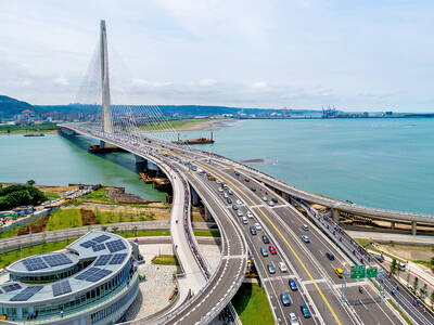
The Ministry of Transportation and Communications yesterday inaugurated the Danjiang Bridge across the Tamsui River in New Taipei City, saying that the structure would be an architectural icon and traffic artery for Taiwan. Feted as a major engineering achievement, the Danjiang Bridge is 920m long, 211m tall at the top of its pylon, and is the longest single-pylon asymmetric cable-stayed bridge in the world, the government’s Web site for the structure said. It was designed by late Iraqi-British architect Zaha Hadid. The structure, with a maximum deck of 70m, accommodates road and light rail traffic, and affords a 200m navigation channel for boats,
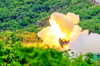
PRECISION STRIKES: The most significant reason to deploy HIMARS to outlying islands is to establish a ‘dead zone’ that the PLA would not dare enter, a source said A High Mobility Artillery Rocket System (HIMARS) would be deployed to Penghu County and Dongyin Island (東引) in Lienchiang County (Matsu) to force the Chinese military to retreat at least 100km from the coastline, a military source said yesterday. Taiwan has been procuring HIMARS and Army Tactical Missile Systems (ATACMS) from the US in batches. Once all batches have been delivered, Taiwan would possess 111 HIMARS units and 504 ATACMS, which have a range of 300km. Considering that “offense is the best defense,” the military plans to forward-deploy the systems to outlying islands such as Penghu and Dongyin so that

Taiwan Semiconductor Manufacturing Co (TSMC, 台積電), the world’s largest foundry service provider, yesterday said that global semiconductor revenue is projected to hit US$1.5 trillion in 2030, after the figure exceeds US$1 trillion this year, as artificial intelligence (AI) demand boosts consumption of token and compute power. “We are still at the beginning of the AI revolution, but we already see a significant impact across the whole semiconductor ecosystem,” TSMC deputy cochief operating officer Kevin Zhang (張曉強) said at the company’s annual technology symposium in Hsinchu City. “It is fair to say that in the past decade, smartphones and other mobile devices were

‘CLEAR MESSAGE’: The bill would set up an interagency ‘tiger team’ to review sanctions tools and other economic options to help deter any Chinese aggression toward Taiwan US Representative Young Kim has introduced a bill to deter Chinese aggression against Taiwan, calling for an interagency “tiger team” to preplan coordinated sanctions and economic measures in response to possible Chinese military or political action against Taiwan. “[Chinese President] Xi Jinping [習近平] has directed the People’s Liberation Army to be ready to invade Taiwan by 2027. China has a plan. America should have one too,” Kim said in a news release on Thursday last week. She introduced the “Deter PRC [People’s Republic of China] aggression against Taiwan act” to “ensure the US has a coordinated sanctions strategy ready should