A new map to be released later this month by China’s National Administration of Surveying, Mapping and Geoinformation increases from 29 to 130 the number of disputed areas marked as officially part of the People’s Republic of China (PRC), including the Diaoyutai Islands (釣魚台) claimed by Taiwan and Japan.
Previous editions of the “Wall Map Series of National Territory,” which presented China’s claimed territory in horizontal format, only included the larger contested islands in the South China Sea in a separate box at the bottom right of the map, Xinhua news agency said at the weekend. The territories included in the box were half scale and not clearly detailed.
The new map is vertical and is to be distributed by Sinomaps Press on behalf of the Chinese authorities starting next month. It will for the first time display the entirety of the PRC’s claimed territory on the same scale as continental China.
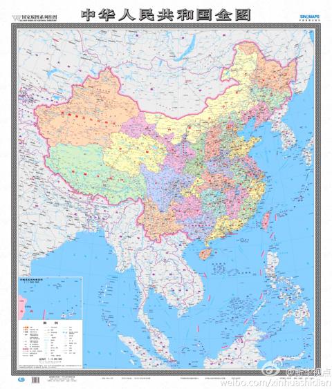
Photo from stcn.com
“The new map will be very significant in enhancing Chinese people’s awareness of national territory, safeguarding China’s marine rights and interests and manifesting China’s political diplomatic stance,” Xu Gencai (徐根才), editor-in-chief at Sinomaps Press, told Xinhua.
In all, the map includes 130 disputed areas, including Taiwan, islets and coral reefs in the Spratlys (Nansha Islands, 南沙群島), the Paracels (Xisha Islands, 西沙群島), the Pratas (Dongshan Islands, 東沙群島), the Macclesfield Bank (Zhongsha Islands, 中沙群島) and the Scarborough Shoal (Huangyan Island (黃岩島), which are the object of disputes between Taiwan, China, the Philippines, Vietnam, Brunei and Malaysia. It also includes the Diaoyutais, in the East China Sea.
In another first, an inset shows the northern tip of Taiwan and detailed mapping of the eight major islets comprising the Diaoyutais, known as the Senkakus by Japan.
Tensions in the area escalated last week, with China and Japan dispatching fighter aircraft after Chinese aircraft penetrated Japan’s Air Defense Identification Zone near the islets on three occasions.
Lu Chang-shui (盧長水), head of the Mainland Affairs Council’s Department of Information and Liaison, said the map was different from the one in new Chinese passports showing Taiwan and the South China Sea as Chinese territory, as well as pictures of Taiwanese tourist spots.
“A passport represents national sovereignty and a map is for a country’s internal use,” Lu said. “Consequently, the council will use different approaches to deal with the map and the passport.”
Lu added that official maps published by the government include the PRC as part of Republic of China (ROC) territory, as dictated by the ROC Constitution.
In related developments, state broadcaster NHK reported yesterday that Japan would deploy two additional patrol ships at its regional coast guard headquarters responsible for territory that includes the Senkakus.
The 335-tonne Kurose and the 3,100-tonne Chikuzen, which comes equipped with a helicopter, will be deployed in August and October respectively, it said.
Meanwhile, during a meeting in Sydney on Sunday, Japanese Minister of Foreign Affairs Fumio Kishida and Australian Minister of Foreign Affairs Bob Carr told a press conference that the two countries had agreed to increase bilateral cooperation on security issues, Kyodo news agency reported yesterday.
Additionally, the Asahi Shimbun reported that Japanese Prime Minister Shinzo Abe would embark on a trip to Southeast Asia tomorrow — his first since assuming office last month — where he will seek to deepen cooperation with ASEAN countries on trade, energy and security matters.
Additional reporting by Shih Hsiu-chuan and AFP
Taiwan has arranged for about 8 million barrels of crude oil, or about one-third of its monthly needs, to be shipped from the Red Sea this month to bypass the Strait of Hormuz and ease domestic supply pressures, CPC Corp, Taiwan (CPC, 台灣中油) said yesterday. The state-run oil company has worked with Middle Eastern suppliers to secure routes other than the Strait of Hormuz, through which about 20 percent of the world’s oil and liquefied natural gas typically passes, CPC chairman Fang Jeng-zen (方振仁) said at a meeting of the legislature’s Economics Committee in Taipei. Suppliers in Saudi Arabia have indicated they
South Korea has adjusted its electronic arrival card system to no longer list Taiwan as a part of China, a move that the Ministry of Foreign Affairs said would help facilitate exchanges between the two sides. South Korea previously listed “Taiwan” as “Taiwan (China)” in the drop-down menus of its online arrival card system, where people had to fill out where they came from and their next destination. The ministry had requested South Korea make a revision and said it would change South Korea’s name on Taiwan’s online immigration system from “Republic of Korea” to “Korea (South),” should the issue not be
CCP ‘PAWN’? Beijing could use the KMT chairwoman’s visit to signal to the world that many people in Taiwan support the ‘one China’ principle, an academic said Chinese Nationalist Party (KMT) Chairwoman Cheng Li-wun (鄭麗文) yesterday arrived in China for a “peace” mission and potential meeting with Chinese President Xi Jinping (習近平), while a Taiwanese minister detailed the number of Chinese warships currently deployed around the nation. Cheng is visiting at a time of increased Chinese military pressure on Taiwan, as the opposition-dominated Legislative Yuan stalls a government plan for US$40 billion in extra defense spending. Speaking to reporters before going to the airport, Cheng said she was going on a “historic journey for peace,” but added that some people felt uneasy about her trip. “If you truly love Taiwan,
A global survey showed that 60 percent of Taiwanese had attained higher education, second only to Canada, the Ministry of the Interior said. Taiwan easily surpassed the global average of 43 percent and ranked ahead of major economies, including Japan, South Korea and the US, data from the Organisation for Economic Co-operation and Development (OECD) for 2024 showed. Taiwan has a high literacy rate, data released by the ministry showed. As of the end of last year, Taiwan had 20.617 million people aged 15 or older, accounting for 88.5 percent of the total population, with a literacy rate of 99.4 percent, the data