Torrential rain brought by Typhoon Nanmadol caused severe flooding in Pingtung County yesterday, damaging more than 600 houses in Hengchun Township (恆春) and claiming one life before heading for China.
Aside from Hengchun, flooding was also reported in Pingtung’s Linbian (林邊), Donggang (東港), Jiadong (佳冬) and Wanluan (萬巒) townships. Two houses in Manjhou Township (滿州) were damaged by a mudslide, although no casualties were reported. The county was also forced to shut down eight bridges because of rising river levels.
A 36-year-old man in Jhongli (中壢), Taoyuan County, was killed by flying glass while he was riding his scooter after a window was blown out by a strong gust of wind.
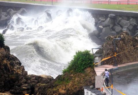
Photo: Huang Chih-yuan, Taipei Times
More than 300 people were trapped by landslides in Wutai Village (霧台), Pingtung County, the Central Emergency Operation Center said, adding that all villagers were safe.
More than 50,000 troops were deployed yesterday to evacuate residents in dangerous areas.
The Soil and Water Conservation Bureau said that by 7pm, 442 mudslide-prone rivers in eastern and southern regions, as well as on the Hengchun Peninsula, were on yellow alert, while 12 in Pingtung County were on red alert.
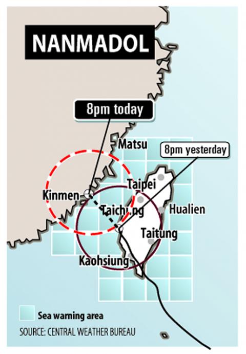
Graphic: TT
The Council of Agriculture (COA) said local governments in those areas should warn residents of the risks and advise them on an evacuation plan.
Air traffic was disrupted by the storm, with about 200 domestic and international flights canceled or delayed because of weather.
The Central Weather Bureau said the typhoon made landfall at 4:20am yesterday at Dawu (大武), Taitung County.
The typhoon had been reduced to a tropical storm by 8am as its structure was damaged after it made landfall. It then moved through Tainan to the Taiwan Strait at about 1pm.
Bureau forecaster Chen Yi--liang (陳怡良) said the storm was expected to move slowly westward toward China and would lose strength along the way.
However, the storm could also linger in the Taiwan Strait for some time, he said.
The bureau could lift the land warning for Taiwan proper this afternoon if the storm maintains its current course and weakens at a pace faster than expected.
While the bureau had lowered the rainfall estimates for eastern and northeastern regions as the typhoon moved westward, Chen said it continued to issue torrential rain alerts for residents in southeastern regions, the Hengchun Peninsula as well as in mountainous areas in the south.
The 10 locations that had -registered the highest accumulated -rainfall were all in Pingtung County, the bureau said.
As of 5:30pm, the center of Nanmadol was located 30km off the southeast coast of Penghu. It was moving northwest at 7kph.
As wind and rain eased in northern and eastern Taiwan, the -Directorate-General of Highways (DGH) reopened the Suhwa Highway at 7am yesterday, which had been closed since 6pm on Sunday.
The South Link Highway became accessible again at 5:30pm.
The section between Dayuling (大禹嶺) and Taroko on the Central Cross-Island Highway was also reopened at 2pm.
The Taiwan Railway Administration said services on the South Link Line would resume first thing this morning. Train services between Hualien and Taitung and along the North Link Line resumed yesterday.
Meanwhile, the COA said agricultural losses from the typhoon were estimated at NT$10 million (US$345,000), with bananas hit the hardest. The torrential rain squalls and gusty winds brought by the storm since Sunday caused heavy damage to crops in Hualien, as well as in Pingtung and Taitung counties, it said. As of 9am yesterday, nearly 374 hectares of farmland had been affected, the council said.
The heaviest damage was to bananas, which sustained losses of more than NT$3 million, the COA said. Banana farms in Pingtung County were the worst hit, it said.Other crops damaged by the storm included sugar apples, watermelons, wax apples and vegetables, it said.
The heavy rainfall nevertheless brought temporary relief from the threat of drought, Taiwan Water Corp (TWC, 台灣自來水) said. The water storage level at the Tsengwen Reservoir, one of the major reservoirs in the south, was just 48 percent before the storm hit as a result of scant precipitation since the spring. The rate had recovered to near full capacity as of yesterday, TWC said.
With Taiwan experiencing the worst drought in eight years, Tsengwen Reservoir was the first reservoir this year to reach full capacity, making rice farmers happy that there would be enough water to plant their first crop next year, TWC said.
Meanwhile, Keelung, which had been on the verge of implementing phase-one water rationing before the storm hit, also received welcome relief from dry conditions. The Hsinshan Reservoir, Keelung’s main source of water, has continued to rise.
By nightfall yesterday, water reserves at the Hsinshan Reservoir were expected to climb to more than 6.1 million tonnes, the threshold at which phase-one rationing will be lifted, the water company said.
Under phase-one water rationing — the lightest rationing measure — water pressure is reduced from 11pm to 5am and water for irrigation is also restricted.
Although the Shihmen Reservoir in Taoyuan County — one of the two major reservoirs supplying water to the Greater Taipei area — also benefited from rainfall brought by Nanmadol over the past two days, the volume still fell short of comfortable levels.
Additional reporting by AFP and CNA

The Ministry of Transportation and Communications yesterday inaugurated the Danjiang Bridge across the Tamsui River in New Taipei City, saying that the structure would be an architectural icon and traffic artery for Taiwan. Feted as a major engineering achievement, the Danjiang Bridge is 920m long, 211m tall at the top of its pylon, and is the longest single-pylon asymmetric cable-stayed bridge in the world, the government’s Web site for the structure said. It was designed by late Iraqi-British architect Zaha Hadid. The structure, with a maximum deck of 70m, accommodates road and light rail traffic, and affords a 200m navigation channel for boats,

PRECISION STRIKES: The most significant reason to deploy HIMARS to outlying islands is to establish a ‘dead zone’ that the PLA would not dare enter, a source said A High Mobility Artillery Rocket System (HIMARS) would be deployed to Penghu County and Dongyin Island (東引) in Lienchiang County (Matsu) to force the Chinese military to retreat at least 100km from the coastline, a military source said yesterday. Taiwan has been procuring HIMARS and Army Tactical Missile Systems (ATACMS) from the US in batches. Once all batches have been delivered, Taiwan would possess 111 HIMARS units and 504 ATACMS, which have a range of 300km. Considering that “offense is the best defense,” the military plans to forward-deploy the systems to outlying islands such as Penghu and Dongyin so that

‘CLEAR MESSAGE’: The bill would set up an interagency ‘tiger team’ to review sanctions tools and other economic options to help deter any Chinese aggression toward Taiwan US Representative Young Kim has introduced a bill to deter Chinese aggression against Taiwan, calling for an interagency “tiger team” to preplan coordinated sanctions and economic measures in response to possible Chinese military or political action against Taiwan. “[Chinese President] Xi Jinping [習近平] has directed the People’s Liberation Army to be ready to invade Taiwan by 2027. China has a plan. America should have one too,” Kim said in a news release on Thursday last week. She introduced the “Deter PRC [People’s Republic of China] aggression against Taiwan act” to “ensure the US has a coordinated sanctions strategy ready should

TAIWAN ISSUE: US treasury secretary Scott Bessent said on the first day of meetings that ‘it wouldn’t be a US-China summit without the Taiwan issue coming up’ There were no surprises on the first day of the summit between US President Donald Trump and Chinese President Xi Jinping (習近平), the Mainland Affairs Council (MAC) said yesterday, as the government reiterated that cross-strait stability is crucial to the Asia-Pacific region, as well as the world. As the two presidents met for a highly anticipated summit yesterday, Chinese state media reported that Xi warned Trump that missteps regarding Taiwan could push their two countries into “conflict.” Trump arrived in China with accolades for his host, calling Xi a “great leader” and “friend,” and extending an invitation to visit the White House