Bangkok is sinking — fast. As urban development continues unabated, this city of more than 10 million people is getting lower by 2cm a year, according to Greenpeace estimates. Meanwhile, the surface of the Gulf of Thailand is rising by 4mm a year — above the global average.
With the Thai capital currently approximately 1.5 meters above sea level, the specters of the 2011 floods that inundated the city and those of last year that killed 1,200 people in India, Nepal and Bangladesh loom large. Recent rainwater floods, plus a UN preparatory meeting on climate change hosted in Bangkok, pushed concerns to the surface once more.
“When I was young I liked floods,” says the architect Kotchakorn Voraakhom, who was born in the city. “I pushed my little boat out and the road became a canal, it was such fun. But after 2011 everyone was like, ‘Oh. What used to be childhood fun has become a disaster.’ And it’s getting worse.”
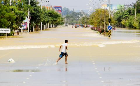
Photo: Reuters
WATER RETENTION
In 2011, Thailand suffered its worst flooding in 50 years. Climate scientist Seri Suptharathit predicts the city will be mostly underwater by the end of the century.
Voraakhom’s ingenious answer was the 4.5-hectare Centenary Park at Chulalongkorn University in the center of the city. Hidden beneath the trees and grass lies its most interesting feature: vast underground water containers that, along with a large pond, can hold a million gallons of water.
Under normal conditions, water that is not absorbed by plants flows into these receptacles, where it is stored for watering during dry periods.
When severe floods hit, the containers hold water and release it into the public sewage system after flooding has subsided. Voraakhom and her architecture firm Landprocess will open a 14.5-acre park with similar water retention functions at Bangkok’s Thammasat University next year.
Centenary Park is also a welcome glimpse of grass in a metropolis that, according to the Economist Intelligence Unit’s Green City Index , has just 3.3 square meters of green space per resident. That compares with 27 square meters in London and 66 square meters in Singapore. Dr Seri Suptharathit, director of the Center on Climate Change and Disaster at Bangkok’s Rangsit University, says even more green has been turned gray since that survey took place in 2011. He says that in the past 20 years the amount of green space in Bangkok has dropped from 40 percent of total land to less than 10 percent — exacerbating flood risk.
‘MONKEY CHEEKS’
Walking around Centenary Park, which opened last year on a site on the Chao Phraya delta previously occupied by university residential buildings, Voraakhom points out trees, and an education center with a lawn roof and herb garden.
“One time last year we had six hours of heavy rainfall and all the roads around here were flooded,” says Voraakhom. “But the park still held the water.”
Her design ethos fits with the “monkey cheeks” water retention initiative pushed by Thailand’s King Bhumibol Adulyadej before he died in 2016. Just as monkeys stuff their cheeks with banana, saving the fruit mush for later, the monarch encouraged Thailand’s Ministry of Agriculture and Cooperatives to help prevent floods by utilizing land areas that could temporarily store water.
Suptharathit believes current flood prevention in Bangkok is too reliant on hard structures such as dams and canals. Voraakhom’s park helps, and Suptharathit proposes paying more farmers to use their land for water retention during the July-October rainy season.
“We don’t think about the use of nature enough,” he says. “Low-elevation rice fields, things like that. Before flowing to Bangkok much of the area [that floodwater travels through] is rural.”
For its part, the city government insists it is responding to increased concern about flooding. It recently announced 28 new flood prevention projects at a cost of 26 billion baht (US$10 million). Flood barriers and underground tunnels are being built, and canals are being dredged and expanded.
’GREEN ZONES’
Sakchai Boonma, director of the Department of City Planning for the Bangkok Metropolitan Administration, says a “green zone” east of Bangkok is already used to retain water for the city. Since 2013, he says, flood concerns have been better addressed by building regulations.
“There must now be space for water to absorb into the ground [of new-builds],” he says. “Bangkok has been expanding in every direction but city planning authorities are prioritizing preventing and fixing flood situations.”
However, Suptharathit says the poor will still feel the brunt of severe flooding. They are likely to live in old buildings not well protected by new anti-flood measures, and are also at risk of being displaced by flood prevention redevelopment around canals.
“The strong can survive with these big structures, but what about the normal people?” he says. “The water will come to them.”
Long-term forecasts by Suptharathit’s research team suggest Bangkok is likely to be hit by serious flooding roughly once per decade, and he predicts that by 2100 the city will be mostly underwater. Tara Buakamsri, Greenpeace’s Thailand director, says: “We just don’t know when a ‘worst-case scenario’ — surge from the sea, rainfall and flooding from the north, all arriving at the same time — will happen.”
Voraakhom admits parks such as hers can only be a tiny part of the solution, but believes they help raise awareness and “show society what can be done in the next 100 years.”
She climbs onto an exercise bicycle fixed to the ground in Centenary Park. It serves the dual purpose of giving users a workout while also churning pondwater to prevent stagnation.
“Is it too late?” she says as she starts pedaling. “I’ve no idea, but we have to do as much as possible.”

Sept.16 to Sept. 22 The “anti-communist train” with then-president Chiang Kai-shek’s (蔣介石) face plastered on the engine puffed along the “sugar railway” (糖業鐵路) in May 1955, drawing enthusiastic crowds at 103 stops covering nearly 1,200km. An estimated 1.58 million spectators were treated to propaganda films, plays and received free sugar products. By this time, the state-run Taiwan Sugar Corporation (台糖, Taisugar) had managed to connect the previously separate east-west lines established by Japanese-era sugar factories, allowing the anti-communist train to travel easily from Taichung to Pingtung’s Donggang Township (東港). Last Sunday’s feature (Taiwan in Time: The sugar express) covered the inauguration of the

The corruption cases surrounding former Taipei Mayor and Taiwan People’s Party (TPP) head Ko Wen-je (柯文哲) are just one item in the endless cycle of noise and fuss obscuring Taiwan’s deep and urgent structural and social problems. Even the case itself, as James Baron observed in an excellent piece at the Diplomat last week, is only one manifestation of the greater problem of deep-rooted corruption in land development. Last week the government announced a program to permit 25,000 foreign university students, primarily from the Philippines, Indonesia and Malaysia, to work in Taiwan after graduation for 2-4 years. That number is a

In a stark demonstration of how award-winning breakthroughs can come from the most unlikely directions, researchers have won an Ig Nobel prize for discovering that mammals can breathe through their anuses. After a series of tests on mice, rats and pigs, Japanese scientists found the animals absorb oxygen delivered through the rectum, work that underpins a clinical trial to see whether the procedure can treat respiratory failure. The team is among 10 recognized in this year’s Ig Nobel awards (see below for more), the irreverent accolades given for achievements that “first make people laugh, and then make them think.” They are not

This Qing Dynasty trail takes hikers from renowned hot springs in the East Rift Valley, up to the top of the Coastal Mountain Range, and down to the Pacific Short vacations to eastern Taiwan often require choosing between the Rift Valley with its pineapple fields, rice paddies and broader range of amenities, or the less populated coastal route for its ocean scenery. For those who can’t decide, why not try both? The Antong Traversing Trail (安通越嶺道) provides just such an opportunity. Built 149 years ago, the trail linked up these two formerly isolated parts of the island by crossing over the Coastal Mountain Range. After decades of serving as a convenient path for local Amis, Han settlers, missionaries and smugglers, the trail fell into disuse once modern roadways were built