It’s hard to believe that Sanmin Bat Cave (三民蝙蝠洞), hidden in the wooded hills off the North Cross-island Highway in Taoyuan City, was only “discovered” in 1923. The cave, 50-meters long, 30-meters in height and 20-meters in depth, is one of Taiwan’s largest. In fact, as far as I know only the Thousand People Cave (千人洞), hidden in a far more remote location high in the rugged mountains of Chiayi County, is bigger.
These days the Bat Cave is one of Taoyuan’s better-known natural wonders, so it’s surprising, perhaps, that until about a decade ago getting to the cave was a bit of an expedition.
Then, as now, a trip to this mysterious, yawning overhang in a rocky cliff (like most examples in Taiwan, it’s not really a true cave) started by following the first few kilometers of the North Cross-island Highway (Highway 7) from the town of Dasi (大溪) to the smaller settlement of Sanmin (三民). The highway forms the main street of this little village, which seems to have been trapped in a time warp, and, unlike nearly Fusing (復興), has changed little in decades.
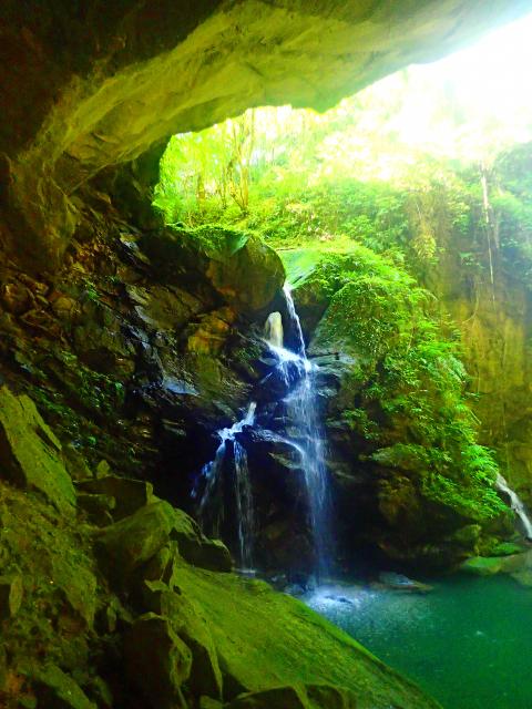
Photo: Richard Saunders
Immediately after crossing a bridge over a stream in the middle of the village, turn left down a signposted lane, passing a church (a reminder that this is Aboriginal country — the Atayal people live in the area).
In exactly three kilometers, the road ends at a parking area: the trailhead for the Bat Cave. Four hundred meters before the car park, a short detour down a road on the left leads to Jiguopai Old Church (基國派老教堂), a small stone chapel, standing in a grassy field and looking for all the world as though it were airlifted in from somewhere in northern Europe. It’s become quite famous in recent years, and attracts a steady stream of visitors.
Until the authorities greatly improved access to the Bat Cave about a decade ago, this was where the fun started, as a narrow track infested with head-high silver grass connected with the top of a fixed rope, an essential aid for negotiating a long, steep and slippery rock face, and getting safely down to the bottom of the gorge below the Bat Cave.
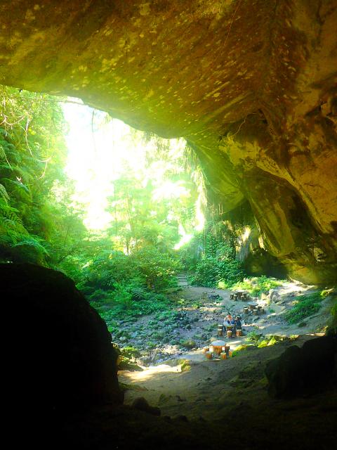
Photo: Richard Saunders
Safely at the bottom, visitors next faced a short but slippery river trace upstream. A large rock, which blocks further progress, required scaling another fixed rope, and a little further upstream the huge mouth of the cave finally loomed in front.
This short but exciting adventure was one of the highlights of a visit to Sanmin Bat Cave, so it’s sad to say the route is no more. Local authorities have created a new route, cutting a stepped path down into the gorge and engineering a wide trail, high and dry above the stream, up to the cave. The resulting experience is less memorable, but it’s still a fascinating and atmospheric place, especially during weekdays (it can get busy on weekend afternoons).
A wooden arch beside the parking area at the end of the road marks the beginning of the new path — a wide, brick-paved track, studded at intervals with tiles painted with spooky black bats. It’s a short uphill climb to a junction next to a small viewing tower. Take the left fork here, and stone steps descend gently into the wooded depths of the gorge just below the Bat Cave. Cross the stream and follow the wide, surfaced path for a minute or two. Climb a series of steps around a large boulder, and the Bat Cave itself suddenly comes impressively into view.
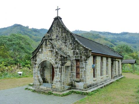
Photo: Richard Saunders
The great overhang lies in a beautiful, sylvan glen hung with ferns and grass, echoing with the sound of a small waterfall which pours into the ravine beside the cave. It’s an impressive sight, even though the bats that once called it home have long-since been scared off by the increasing number of visitors. Try to arrive around the middle of the day, when the sunlight briefly streams into the usually gloomy gorge.
Beside the great overhang lies a smaller but fascinating natural curiosity. The 15-meter-high waterfall that plunges into the gorge beside the cave has worn a small but beautifully formed natural hole through the solid rock. If you follow the brick road straight ahead at the junction next to the viewing tower above the Bat Cave, it soon ends at a dirt path that leads to a second natural cave a couple of kilometers (40 minutes’ walk) to the east: Guanyin Cave (觀音洞). Look out on the left just after the beginning for a side trail that leads down to the brink of the waterfall beside the Bat Cave for an unusual view over it (but beware the very slippery mossy rocks in the streambed).
For years, the path to Guanyin Cave was spared the excesses of the well-meaning but sometimes ecologically insensitive local authorities, and was a beautiful short walk beside two mossy streams, passing a pretty waterfall. Unfortunately, work began last month on “improving” the path, and the natural beauty of the trail is already being compromised. At the end is a gate on the edge of the compound of the large temple built in front of Guanyin Cave. The huge temple building itself is functional rather than decorative, but behind it, dominating the view and visible for miles around, is a huge, gleaming gold statue of the seated Guanyin, which is an impressive sight.
Richard Saunders is a classical pianist and writer who has lived in Taiwan since 1993. He’s the founder of a local hiking group, Taipei Hikers, and is the author of six books about Taiwan, including Taiwan 101 and Taipei Escapes. Visit his Web site at www.taiwanoffthebeatentrack.com.

Sept.16 to Sept. 22 The “anti-communist train” with then-president Chiang Kai-shek’s (蔣介石) face plastered on the engine puffed along the “sugar railway” (糖業鐵路) in May 1955, drawing enthusiastic crowds at 103 stops covering nearly 1,200km. An estimated 1.58 million spectators were treated to propaganda films, plays and received free sugar products. By this time, the state-run Taiwan Sugar Corporation (台糖, Taisugar) had managed to connect the previously separate east-west lines established by Japanese-era sugar factories, allowing the anti-communist train to travel easily from Taichung to Pingtung’s Donggang Township (東港). Last Sunday’s feature (Taiwan in Time: The sugar express) covered the inauguration of the

The corruption cases surrounding former Taipei Mayor and Taiwan People’s Party (TPP) head Ko Wen-je (柯文哲) are just one item in the endless cycle of noise and fuss obscuring Taiwan’s deep and urgent structural and social problems. Even the case itself, as James Baron observed in an excellent piece at the Diplomat last week, is only one manifestation of the greater problem of deep-rooted corruption in land development. Last week the government announced a program to permit 25,000 foreign university students, primarily from the Philippines, Indonesia and Malaysia, to work in Taiwan after graduation for 2-4 years. That number is a

In a stark demonstration of how award-winning breakthroughs can come from the most unlikely directions, researchers have won an Ig Nobel prize for discovering that mammals can breathe through their anuses. After a series of tests on mice, rats and pigs, Japanese scientists found the animals absorb oxygen delivered through the rectum, work that underpins a clinical trial to see whether the procedure can treat respiratory failure. The team is among 10 recognized in this year’s Ig Nobel awards (see below for more), the irreverent accolades given for achievements that “first make people laugh, and then make them think.” They are not

This Qing Dynasty trail takes hikers from renowned hot springs in the East Rift Valley, up to the top of the Coastal Mountain Range, and down to the Pacific Short vacations to eastern Taiwan often require choosing between the Rift Valley with its pineapple fields, rice paddies and broader range of amenities, or the less populated coastal route for its ocean scenery. For those who can’t decide, why not try both? The Antong Traversing Trail (安通越嶺道) provides just such an opportunity. Built 149 years ago, the trail linked up these two formerly isolated parts of the island by crossing over the Coastal Mountain Range. After decades of serving as a convenient path for local Amis, Han settlers, missionaries and smugglers, the trail fell into disuse once modern roadways were built