There’s a curious consensus among many lovers of the Matsu islands that Dongyin (東引) is the most beautiful. With it’s easternmost peninsula, the famous Lienyu Yikeng Cliff (烈女義坑, also known as Suicide Cliff), stunningly situated lighthouse and extraordinary Yisiantian (一線天, also known as Thread of Sky), Dongyin has a lot on offer. Yet the island also has the heaviest remaining military presence of any in the Matsu group. Until nature is allowed to take over and soften many a cruel blemish and scar, visitors will have to ignore many eyesores en route to Dongyin’s scenic highlights.
On the frontline
Dongyin is connected with the neighboring island of Xiyin (西引) by a causeway, and while this sister islet is less visited, it has several natural and militaristic sights of great interest. Incidentally, the heavy military presence on both islands means it’s best to keep your ID on you while exploring — on my last visit it was still needed to visit a couple of the sights — and be careful where you point your camera.
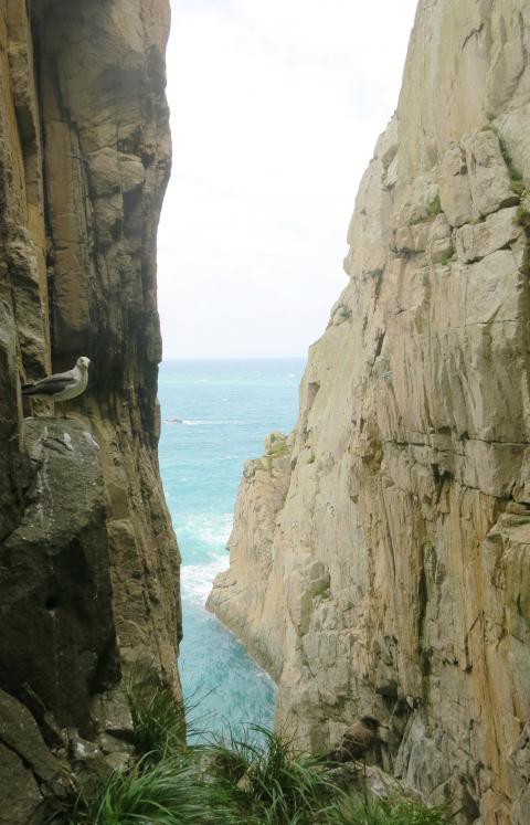
Photo: Richard Saunders
Ferries from Taiwan and Nangan Island (南竿島) all dock at Jhongjhu Harbor (中柱港), at the southern edge of Jhongliou (中柳村) and Lehua (樂華村) villages, which mingle to form the main settlement on the island.
Heading south from the harbor, the coast road climbs high above the ocean to turn west at Dongyin Visitor Center (東引旅客中心), where a side road descends to the seashore and Beihai Tunnel (北海隧道), dug between 1968 and 1970. At 148 meters, it’s the smallest of the three subterranean harbors in the Matsu islands. The others are on Nangan and Beigan (北竿) islands, but, like those, this one was dug by hand with the aid only of dynamite. Unfortunately it’s been “temporarily” closed for many years now, since the roof of the tunnel is apparently unstable.
Caves and tunnels
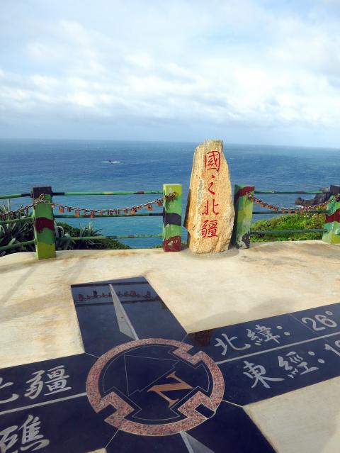
Photo: Richard Saunders
After the visitor center, take the next (signposted) turn on the right, and follow the signs to the trailhead for the short walk out to “Yanxiao Echoing with Tidal Cave” (燕秀潮音). This notable example of Chinglish describes a huge cavern whose roof has fallen in, exposing a deep, narrow crater, linked to the ocean by a long cleft, through which the sea pounds with an impressive roar. The cliffs on the crater side are densely covered in foliage so it’s hard to see into the void, but even half-glimpsed it’s an impressive place.
The main road now heads inland back toward Lehua village and Dongyin Distillery (東引酒廠), founded in 1961 and one of two distilleries in Matsu that produce Kaoliang spirit.
A kilometer or so further east, along a succession of signposted roads, lies Andong Tunnel (安東坑道), Dongyin’s most impressive military relic (excavated in the 1970s), and an unmissable attraction. The entrance to the complex is via a long, descending and seemingly endless tunnel which presents an interesting optical illusion, as it’s far longer than at first appears as you walk down. At the bottom, tunnels branch off in different directions, several ending suddenly at dramatic viewpoints in vertical sea cliffs. The gun turrets at Andong Tunnel are favorite bird watching spots, and the sight of large flocks of seagulls and terns circling in the deep sea-worn chasms is one of Matsu’s most memorable experiences.
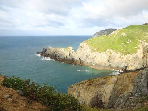
Photo: Richard Saunders
The western half of Dongyin has some impressive sights, but it’s the easternmost peninsula of the island (just a short zip by hire scooter from Jhongliu village) where the most breathtaking coastal scenery is found. First, below a small military compound, is the incredible cleft, Thread of Sky. A soldier may or may not walk up with pen and paper as you draw up at the parking area. Sign in with your ID if he does, and follow the steps down the grassy hillside and into the crevice. Thread of Sky isn’t especially big, but it’s extremely narrow, as the name suggests, and the short walk down there is stunning.
Killer views
Another couple of hundred meters east, steps lead down from the road to the utterly spectacular Suicide Cliff, rightly Dongyin’s most famous sight. It’s just a few meters from the road to the end of the natural, diving board-like tongue of land that extends into this fearsome ocean-eroded chasm, but the view down the sheer cliffs to the rocks far below is guaranteed to give vertigo sufferers a severe case of the willies.
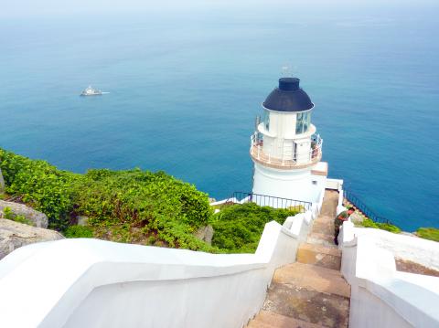
Photo: Richard Saunders
Historic monument
At the easternmost tip of the island a path follows the cliffs to the historic, British-designed Dongyin Lighthouse (東引燈塔), a Grade Three Historic Monument completed in 1904.
The lighthouse stands in a wild and magnificent spot, halfway up a craggy cliff, and the views over the cliffs and the ocean far below are inspirational on a good day. A side trail on the right on the way to the lighthouse leads down the cliffs to a pair of fog cannons, used in the past when poor visibility meant the lighthouse was ineffective.
The independent island of Xiyin is joined to the bigger Dongyin by the 500 meter-long Jhongjhu causeway (completed in 1986). Once across the causeway, follow the road uphill onto Xiyin’s steep slopes and several fine natural and military attractions. Most unmissable is the clifftop viewing platform called the Guojhih Beijiang (國之北疆), or Northernmost Frontier.
This point (or rather the Beigu Reef (北固礁) just offshore) constitutes the northernmost territory of the Matsu archipelago, and is certainly a fittingly majestic spot. The view, incorporating the rock pinnacles of the Luohanping (羅漢坪), or Eighteen Luohan, is as wild and exhilarating as any to be found in Taiwan.
Richard Saunders is a classical pianist and writer who has lived in Taiwan since 1993. He’s the founder of a local hiking group, Taipei Hikers, and is the author of six books about Taiwan, including Taiwan 101 and Taipei Escapes. Visit his Web site at www.taiwanoffthebeatentrack.com.

Taiwan’s overtaking of South Korea in GDP per capita is not a temporary anomaly, but the result of deeper structural problems in the South Korean economy says Chang Young-chul, the former CEO of Korea Asset Management Corp. Chang says that while it reflects Taiwan’s own gains, it also highlights weakening growth momentum in South Korea. As design and foundry capabilities become more important in the AI era, Seoul risks losing competitiveness if it relies too heavily on memory chips. IMF forecasts showing Taiwan widening its lead over South Korea have fueled debate in Seoul over memory chip dependence, industrial policy and

And so, in the wake of US President Donald Trump’s trip to the People’s Republic of China (PRC), all the experts on the Strait of Hormuz suddenly became experts on US-China-Taiwan relations. The Internet has certainly expanded human knowledge. Lots of these sudden experts made noise this week about Trump’s words after the meeting with PRC dictator Xi Jin-ping (習近平). Trump is going to sell out Taiwan! Longtime Taiwan commentator J. Michael Cole summed the situation up neatly in the Guardian: “We need to keep in mind that he has a tendency to say many things — sometimes contradicting himself within

There is considerable frustration and confusion among many, both in Taiwan and abroad — including in Washington — as to why the Chinese Nationalist Party (KMT) seems so dead set on using their legislative leverage to slash defense spending and disrupt the ability of the ruling Democratic Progressive Party (DPP) administration to function. Are they pawns of the Chinese Communist Party (CCP)? Are they traitors? In reality, there are multiple reasons. In the first column in this series on this subject, “Donovan’s Deep Dives: How and why the TPP and KMT help Beijing” (Sat May 16, page 12), we examined three

It took 12 years and months of standing in the same mountain location for director Liang Chieh-te (梁皆得) to capture a few seconds of footage: Taiwan’s largest resident raptor locking talons with its mate and spinning through the air in a courtship ritual. With only about 1,000 left in the wild and very short flight windows, the mountain hawk-eagle remains among Taiwan’s most elusive birds. The species generally produces only one offspring per year. Using forest cameras, the film crew and research teams document the arduous process the monogamous pairs go through for the chick to hatch and grow up, weathering