Over 70 years on, memories of a half-century of Japanese colonization may have dimmed, but its legacy lives on in, not least in the many Japanese-era buildings found in the cities of Taiwan’s coastal plains, from Keelung to Kaohsiung.
Although forced to leave Taiwan at the end of the Second World War, the Japanese left evidence of their control of the nation’s main island not only in sumptuous, Western-inspired architecture and a much-improved road network, but also in a series of secondary routes across the central mountains that could only be followed on foot or horseback. These military communication arteries were primarily intended to suppress the island’s Aborigines, and at regular intervals along each was a police outpost or fort.
A few routes from that time, for instance the epic, 125-km Batongguan Traversing Trail (八通關越道), and the much shorter Paoma (“running horse”) Old Trail (跑馬古道) in Yilan County, have been cleared for hikers to follow. The majority, though, are either only very occasionally visited by intrepid hiking groups, or have been completely lost to the returning jungle, and today exist only on hiking maps as lines marking non-existent trails, or the names of former settlements and military camps deep in the virtually inaccessible central mountains.
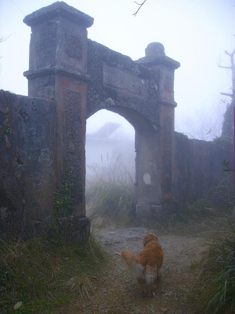
Photo: Richard Saunders
Very few physical remains of these mountain forts, police outposts and settlements can be seen today, although several popular trails (including the Walami Trail, 瓦拉米步道, in southern Hualien County and the Zhuilu Old Trail, 錐麓古道, in Taroko Gorge) pass the flat, open areas where they once stood. I can think of only two Japanese forts in Taiwan’s mountainous interior that survive reasonably intact. One is just off the South Cross-island Highway in Taitung County, and the second is Lidong Fort (李崠山古堡), atop a 2,000-meter-high mountain in Hsinchu County.
The old fort atop Mount Lidong is perhaps the most interesting Japanese-built fortification on the island. The fort dates from the early years of the colonial period.
After landing on Taiwan on March 29, 1895, Japanese soldiers quickly spread across the island, subduing resistance, and although small groups of rebel Han Chinese forces held out for a while in several mountain areas in the north of the island, most of Taiwan’s heavily populated lowland areas were under Japanese control by the end of that year.
Photo: Richard Saunders
Subduing the island’s aboriginal peoples, who had been pushed by several centuries of Han migration deep into the central mountains, proved a much tougher job, and one that was left to General Count Sakuma Samata (佐久間左馬太), who was named the fifth Governor-General of Taiwan in April 1906.
Samata immediately buckled down to the job of teaching the Atayal aboriginals of northern Taiwan to bow to authority. He began a five-year campaign, during which he led several armed attacks against them. During a 1911 campaigns, an army of 2,000 troops set out to take Mount Lidong, capturing it after heavy fighting, which resulted in heavy casualties on both sides. A fort was built on the site, and strengthened the following year after continuing resistance from the Atayal, who finally gave up the fight in 1913.
Today all that remains of the fort are its four walls, which enclose a rectangular area 28 meters by 22 meters. The walls, about three meters high, are just over half a meter thick. Despite its military function, the Japanese couldn’t resist throwing a little style into the design; the main entrance gate is rather fine, although a plaque that once hung above the entrance arch has disappeared. There’s little to explore inside: the structure is essentially an empty shell with a collection of radio aerials and a trig point in the middle.
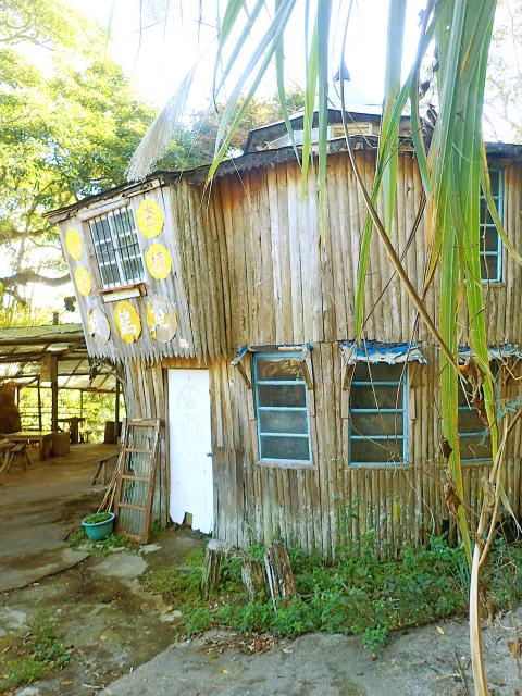
Photo: Richard Saunders
Apart from its interesting history, the main reason to visit Mount Lidong Fort is its location. Perched atop a mountain at 1,913 meters, it makes a great trip, first by vehicle and then on foot, into one of northern Taiwan’s remoter corners.
Arriving at the trailhead, it’s impossible to miss the richly eccentric Mount Lidong Villa (李崠山莊), and its tumbledown hotchpotch of ornamental pavilions, covered terraces, corridors and footbridges is something of an attraction in its own right. As you pass through you’ll almost certainly meet and get to chat with the shelter’s friendly owner, a retired army soldier who collects a small fee for the privilege of sweating up the steep, hour-long trail to the fort.
There’s a height increase of 400 meters between the villa and the fort, and the trail (clearly marked with signposts and plastic trail-marking ribbons) is a seemingly endless series of steep zigzags. After about half-an-hour, the trail meets a stony track which leads to the summit and the fort. Follow either the easier winding track, or take the much steeper short-cuts that intersect it at intervals, and about an hour after leaving the villa, the gateway of Mt. Lidong Fort looms out of the fast-encroaching forest.
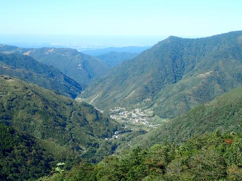
Photo: Richard Saunders
There’s a fantastic view over the central mountain range if you can find a break in the tall grass and trees that now encircle the fort walls; otherwise climb a few meters up the ladder serving one of the aerials inside the fort. Snow Mountain (雪山), Taiwan’s second highest and Mount Nanhuda (南湖大山), its fifith, are visible on a clear day. But even if the mist has already rolled in, defeating any ambitions of enjoying the superb panorama, the dead silence and slightly eerie atmosphere of the site makes it a place to linger awhile, before heading down for another chat, and perhaps a cup of tea, back at the trailhead.
Richard Saunders is a classical pianist and writer who has lived in Taiwan since 1993. He’s the founder of a local hiking group, Taipei Hikers, and is the author of six books about Taiwan, including Taiwan 101 and Taipei Escapes. Visit his Web site at www.taiwanoffthebeatentrack.com.

Ajay Verma, a consultant gastroenterologist at Kettering general hospital in Northamptonshire, says our gut is a “complex machine.” “It is constantly providing us with the nutrition we need, initially to grow and develop, and then for us to survive, thrive and repair from injury and illness.” How can we keep it functioning well? Put simply: “Make sure what you put into it is balanced, and that you clear out its waste products adequately,” Verma says. “In a general gastroenterology clinic, the most common conditions we see are irritable bowel syndrome (IBS), gastroesophageal reflux disease, inflammatory bowel disease and constipation,” says Nisha
The arithmetic is straightforward and uncomfortable. By the end of 2025, Taiwan had committed itself to a 50-30-20 electricity mix — half natural gas, 30 per cent coal, 20 per cent renewables. The Ministry of Economic Affairs’s (MOEA) own monthly energy reports tell a different story. Natural gas reached 47.8 per cent of generation last year. Coal stood at 35.4 per cent, comfortably above its target ceiling. Renewables came in at 13.1 per cent, well short of the 20 per cent Taipei had pledged a decade earlier. Installed renewable capacity reached roughly half of the 12 gigawatts (GW) the government

Last week US President Donald Trump was asked by a reporter whether he would speak on the phone to the President of Taiwan. “l’ll speak to him. I speak to everybody. We have that situation very well in hand,” Trump said. This marked the second time in a couple of weeks he had said he would talk to the President of Taiwan. In 2016 he famously took a call from then-president Tsai Ing-wen (蔡英文), when he was president-elect. Despite warnings that the apocalypse was nigh because of a phone call, the world quickly forgot about the conversation between two democratically-elected presidents.
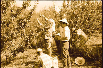
May 25 to May 31 Few believed that apples could be cultivated on a commercial scale in Taiwan’s high mountains. When horticulturalist Cheng Chao-hsiung (程兆熊) first proposed the idea in 1955, both American and Taiwanese colleagues dismissed it as implausible, arguing that temperate fruit could not be reliably grown on a subtropical island, especially on rugged terrain. However, it was this terrain in the Central Mountain Range where many Chinese Civil War veterans were resettled in the late 1950s. With limited job prospects and no family in Taiwan, they were placed on cooperative farms aimed toward self-sufficiency. Some say the conditions