The in-car GPS system is without doubt one of the "it" gadgets of the moment, and they will be gracing many a Christmas tree come December. With its wealth of experience in building small electronic devices combining touch screens and wireless technologies, Taiwan was bound to pick up on the trend. Here is a look at how two Taiwanese brands compare to Netherlands-based TomTom, the global leader in GPS devices.
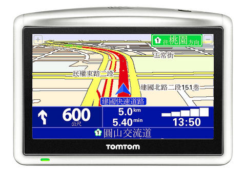
As soon as the packaging is opened, the ONE XL exudes confidence with its simple and sturdy construction. The only physical switch, on the top of the unit, is the power button; all other interaction is handled on the touch screen with a series of gestures and swipes that is both fun and intuitive. Details include the small brow on the top edge of the screen that helps block glare from the sun and provides a useful grip when sliding it into the docking mount.
The accessories that are included with the unit are also of higher-than-average quality. ONE XL gets top marks for the window mount that doesn't look like an architectural joist - it's good-looking enough to leave in place and small enough to safely stow away in the glove box.

In use, the software is clear and precise, though, like any navigation system, it is prone to occasional quirky routes with hilarious comic timing such as the voice thoughtfully directing the driver to turn around on a busy six-lane highway. Passengers also became highly alarmed when what sounded like a steam train barreling down Zhongxiao Road straight at the car turned out to be the auditory warning of an approaching speed camera.
Those considering the ONE XL may well want to look further down the product range. The ONE device lacks the 4.3 inch screen display and some of the features of its more expensive brethren, but the compact dimensions may be a plus for drivers with cramped interiors. Those who do want the extra screen real estate may want to wait for the GO 720 that will be launched this month sporting, among other things, voice control.
Mitac is the premier Taiwanese manufacturer of GPS devices and has many years of experience in the field. The Mio C720T is one of the latest GPS systems and has a couple of features that make it special.
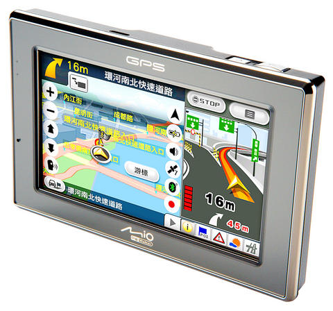
The first of these is a 2 megapixel digital camera on the back of the device. This allows you to take a photo of a business card and use this as the destination of the journey. It's a great idea, but in reality the performance was less than perfect, and it was often quicker to manually enter the address. The other interesting feature was combining the photo with "geo-tagged" information - tracking the location of each photo. It's a fantastic addition, but there needs to a be a little more development work on the services side.
The design is much more angular than the subtler TomTom. Although it had a decent 4.3 inch screen, the chrome detailing meant that on sunny days glare became a problem, and at nighttime the row of LEDs became a little distracting.
Accessories-wise, the window mount is a little bulky and includes multiple screw adjustments for alignment and angle, and it allows you to leave the power plugged in to the dock when the device is removed. Unlike the TomTom, a mains power adaptor is included for charging at home.
The user interface is not as polished as the TomTom and certainly requires a little more learning as a result.
The Acer c500 takes a slightly different approach from the dedicated unit. In this case, the company employs a Microsoft Windows PDA and uses the included Papago software and GPS antenna to do the work. The styling is pretty neat, and it is certainly small enough to stow away in a purse or bag, with the obvious advantage of being able to run other software on top of the navigation functions. As ever, there are trade-offs to be had between small size and large display.
The downside of multi-functions is that the device is not quite so good at pure navigation, and forgoes the touch screen interaction in favor of stylus-led input. This is all very well when sitting at home planning the route, but mid-journey adjustment becomes more difficult when poking around with a stick on the small 2.8 inch screen. However, Papago is arguably the most highly developed mapping software for Taiwan, and it is likely to pick up on many of the charming intricacies of the road system.
The rapid growth of smart phones has, no doubt, squeezed the PDA market a great deal. As a result, for a little more money, it is possible to get a similarly-sized device that can also place phone calls. For those migrating from PDAs without GPS functionality, however, this would be a very handy upgrade.
Regardless of which device you choose, the next generation will carry not memories of parents battling with maps and road signs, but with an inanimate bit of plastic.
Jonathan Biddle is head of Industrial Design at DEM INC

Taiwan’s overtaking of South Korea in GDP per capita is not a temporary anomaly, but the result of deeper structural problems in the South Korean economy says Chang Young-chul, the former CEO of Korea Asset Management Corp. Chang says that while it reflects Taiwan’s own gains, it also highlights weakening growth momentum in South Korea. As design and foundry capabilities become more important in the AI era, Seoul risks losing competitiveness if it relies too heavily on memory chips. IMF forecasts showing Taiwan widening its lead over South Korea have fueled debate in Seoul over memory chip dependence, industrial policy and
“China wants to unify with Taiwan at the lowest possible cost, and it currently believes that unification will become easier and less costly as time passes,” wrote Amanda Hsiao (蕭嫣然) and Bonnie Glaser in Foreign Affairs (“Why China Waits”) this month, describing how the People’s Republic of China (PRC) is playing the long game in its quest to seize Taiwan. This has been a favorite claim of many writers over the years, easy to argue because it is so trite. Very obviously, if the PRC isn’t attacking Taiwan, it is waiting. But for what? Hsiao and Glaser’s main point is trivial,
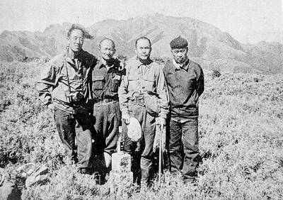
May 18 to May 24 Gathered on Yangtou Mountain (羊頭山) on Dec. 5, 1972, Taiwan’s hiking enthusiasts formally declared the formation of the “100 Peaks Club” (百岳俱樂部) and unveiled the final list of mountains. Famed mountaineer Lin Wen-an (林文安) led this effort for the Chinese Alpine Association (中華山岳協會). Working with other experienced climbers, he chose 100 peaks above 10,000 feet (3,048m) that featured triangulation points and varied in difficulty and character. The list sparked an alpine hiking craze, inspiring many to take up mountaineering and competing to “conquer” the summits. A common misconception is that the 100 Peaks represent Taiwan’s 100 tallest

Yesterday, the Democratic Progressive Party (DPP) nominated legislator Puma Shen (沈伯洋) as their Taipei mayoral candidate, the Chinese Nationalist Party (KMT) put their stamp of approval on Wei Ping-cheng (魏平政) as their candidate for Changhua County commissioner and former legislator Tsai Pi-ru (蔡壁如) of the Taiwan People’s Party (TPP) has begun the process to also run in Changhua, though she has not yet been formally nominated. All three news items are bizarre. The DPP has struggled with settling on a Taipei nominee. The only candidate who declared interest was Enoch Wu (吳怡農), but the party seemed determined to nominate anyone