People in Taiwan seem to have a fascination with maps, which is odd considering that a vast majority of those published in Taiwan, be they tourist or transport maps, are incorrect and impossible to comprehend.
The population might be cartographically challenged, but this doesn't stop books focusing on old maps of Taiwan from becoming bestsellers, copies of the Council for Cultural Affairs' (CCA,
And the current Taiwan in Maps (
PHOTOS COURTESY OF NATIONAL TAIWAN MUSEUMN
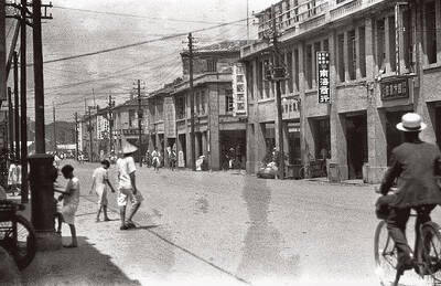
Taiwan in Maps is one of the largest exhibitions to be hosted by the museum in recent years, and the extensive and fascinating displays are located in exhibition halls on all three floors of the museum.
Jointly organized by the CCA and the museum, the exhibition features dozens of original maps and an equal number of reproductions and copies, along with photographs and other artifacts related to cartography in Taiwan.
While those with a whim for cartography and/or Taiwan history will have already seen some of the better-known maps on display and in various publications, there are still plenty of maps in the exhibition that will stoke the interests of anyone with an eye for geography or history.
The exhibition is well-organized and covers every conceivable topic and theme, from the earliest maps of Taiwan hand drawn by Portuguese and Spanish explorers in the 15th century to explanations of cutting-edge satellite imagery used by cartographers now.
Along with the multitude of geographic and topographic maps, there are also plenty of demographic maps on display. These include maps that plot Taiwan's indigenous peoples, the nation's economic growth, Taiwan's farming production and its transportation networks.
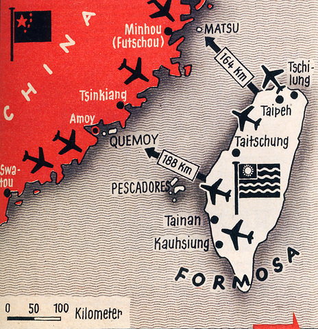
Although the maps are far too numerous to give a detailed account of all those on display, a couple of the most eye-catching charts include a simplified military map from 1958 showing the possible flight paths of military aircraft in the event of war with China, and a highly detailed map of Taiwan drawn by members of the Royal Geographic Society in 1864.
Taiwan in Maps is comprehensive and gives visitors insight into the history of cartography in Taiwan, but it is not without its flaws. As is all too often the case with exhibitions in Taiwan, be they at national or regional level, the lack of English-language information is big disappointment. Considering President Chen Shui-bian (
language material is in this instance best described as deplorable.
In addition to the exhibition, the museum has also published a comprehensive guidebook, which features a myriad of glossy photographs and explanations of many of the maps on display. Like the explanations that accompany the exhibits, the Taiwan in Maps guidebook is only available in Chinese.
Event Information:
What: Taiwan in Maps (
Where: National Taiwan Museum (
When: Through Sept. 18

Taiwan’s English education system is being pulled apart by three opposing forces. Bilingual Nation 2030 pulls students toward English and global communication. Artificial Intelligence (AI) readiness pulls them toward digital judgment, verification and AI-mediated work. But Taiwan’s old exam culture pulls them back toward memorization, grammar drills, timed reading and correct answers. If the education system keeps using old exams to define success, it risks producing graduates who are neither genuinely bilingual nor genuinely AI-ready, but trained for tasks machines can already perform. The first force is Bilingual Nation 2030. Launched in 2018, the policy aimed to “help Taiwan’s workforce connect
It seems every few days one bumps into one of those “real man” comments in which Taiwan is urged to “face reality” or similar, and “make a deal,” with the speaker implying that soon it will be too late. “Deal” advocates always present themselves as having a superior grip on reality, and the manly ability to make the “hard choice.” Their testosterone-laden language often echoes that of Taiwan sellout advocates. Note that such commentary always specifies a process (“make a deal, work with, make progress”), never the end state of what occupation by a violent authoritarian colonialist state will entail. In
There are shadowy cabals plotting to sell out Taiwan to be annexed by China, by invasion if necessary. Fortunately, they are buffoons. In 2019, former Bamboo Union gangster and founder of the China Unification Promotion Party (CUPP), Chang An-le (張安樂, colorfully known as “White Wolf”), led a protest at the Legislative Yuan against comments made by then-premier Su Tseng-chang (蘇貞昌) that in the event of an attack by China, he would never surrender, but would protect the nation by fighting to the end, even if he only had a broom. Chang had party members bring a wooden casket that they
June 1 to June 7 "If all Taiwanese were as afraid of dying as you, then what would happen?” Physician Shih Chiang-nan (施江南) reportedly said this to his wife Chen Chiao-tung (陳焦桐) after she urged him to stop intervening on behalf of Taiwanese soldiers stranded overseas after serving in the Japanese Army during World War II. Shih had clashed with high-ranking officials over the issue, engaged in several heated arguments with Taiwan governor-general Chen Yi (陳儀) and allegedly shouted at general Ko Yuan-fen (柯遠芬), chief of staff of the Taiwan Garrison Command, over