Authorities in Hualien County are preparing for possible large-scale evacuations as Typhoon Fung-Wong approaches Taiwan, with officials warning that extreme rainfall could trigger the formation of a new landslide lake on the Mataian River (馬太鞍溪).
The Forestry and Nature Conservation Agency yesterday said that a new barrier lake could form if three extreme conditions occur simultaneously — 24-hour accumulated rainfall of 800mm, the collapse of the existing Mataian barrier lake holding about 1.5 million cubic meters of water, and a massive slope landslide blocking the river channel.
If these conditions are met, the resulting lake could store up to 15 million cubic meters of water and, if it later collapses, could unleash floodwaters at a peak rate of about 4,500m³ per second, the agency said.

Photo courtesy of the Forestry and Nature Conservation Agency’s Hualien branch
Monitoring data yesterday showed the current Mataian barrier lake’s water level at 1,019.5m, with a volume of about 1.49 million cubic meters — only 1.6 percent of its pre-overflow level.
The downstream slope remains stable, with no signs of major collapse, the agency said.
With forecasts of nearly 282mm of rain over the next 48 hours, the agency’s Hualien Branch issued a yellow alert yesterday morning and sent emergency cell-broadcast messages to residents downstream, urging them to follow evacuation instructions if a red alert is issued.
Guangfu Township (光復), located downstream of the creek, has begun preparations for potential evacuations affecting more than 5,500 residents, township chief Lin Ching-shui (林清水) said.
Plans include relocation to seven designated shelters, staying with relatives, or moving to higher floors in homes, Lin said, adding that about 1,420 people are expected to take shelter in evacuation centers such as Guangfu Elementary School and Fuyuan Junior High School.
Lin said shelters would be set up this morning, and evacuation would begin once a red alert is issued.
Households that were submerged by more than 1.5m of floodwater during the overflow of the Mataian barrier lake on Sept. 23 would be required to evacuate rather than shelter in place, he added.
The Central Weather Administration said earlier that a sea warning for Typhoon Fung-Wong could be issued as early as this afternoon.

FUKUOKA SITUATION: Japanese media reported that the pathogen is expected to be identified by the summer, while the CDC downplayed the idea that it was hMPV A “mysterious cold-like illness” reported in Japan’s Fukuoka Prefecture does not seem to be a new disease, but Japanese authorities have been asked about the situation, the Centers for Disease Control (CDC) said yesterday. The Fukuoka Prefectural Medical Association on Wednesday told a news conference that a “mystery cold” that has become a hot topic on social media is “highly likely to be caused by some kind of viral infection,” Japan’s KBC News reported. “Many people are experiencing symptoms starting with a sore throat, followed by a runny nose, phlegm and a severe cough,” KBC News reported, citing association officials. Health authorities are

Nvidia Corp CEO Jensen Huang (黃仁勳) arrived in Taiwan yesterday ahead of upcoming AI and technology events, saying he plans to meet with clients and Taiwan Semiconductor Manufacturing Co Chairman C.C. Wei (魏哲家) during his visit. After landing at Taipei Songshan Airport, Huang posed for photos with fans and handed out Yakult drinks to reporters and supporters waiting at the scene, saying he has “a lot to do” during the trip. Asked about reports that Nvidia’s planned headquarters site in Taipei’s Beitou Shilin Technology Park could break ground on May 27, Huang said that if the company holds an event, he would
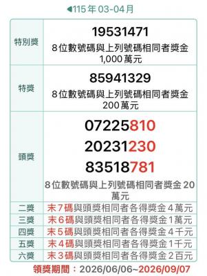
The Ministry of Finance this afternoon announced the winning numbers for the March-April uniform invoice lottery. The winning number for the NT$10 million (US$318,060) special prize is 19531471, and the winning number for the NT$2 million grand prize is 85941329. Three numbers were drawn for the NT$200,000 first prize: 07225810, 20231230 and 83518781. Those with receipts matching the last seven digits of any of the first-prize numbers will win the NT$40,000 second prize, while those matching the last six digits will win the NT$10,000 third prize. Those whose receipts match the last five digits of the first-prize numbers can claim the NT$4,000 fourth prize,

SIX SUBSIDIES: The monthly allowance for older farmers is to increase to NT$10,000, and NT$5,000 is to be given to homemakers under the national pension system, Lai said The government is to implement major welfare policies for disadvantaged groups, including raising the monthly allowance for older farmers to NT$10,000 and providing homemakers with NT$5,000 per month, President William Lai (賴清德) said yesterday. Lai made the remarks during a visit to Wangling Temple in Chiayi County, saying that the planned increases were being introduced amid economic growth and an increase in tax revenue. Touting a policy, in which the government plans to provide a monthly allowance of NT$5,000 for every child under the age of 18 in a bid to address Taiwan’s low birthrate, Lai said that if received for the