The Central Emergency Operations Center (CEOC) has made a three-phased compulsory evacuation plan for Hualien County’s Mataian River (馬太鞍溪) disaster zone ahead of the potential formation of a typhoon.
The plan includes mandatory vertical evacuation using air-raid-style alarms if needed, CEOC chief coordinator Chi Lien-cheng (季連成) told a news conference in the county yesterday.
Volunteers would be prohibited from entering the disaster area starting tomorrow, the retired general said.
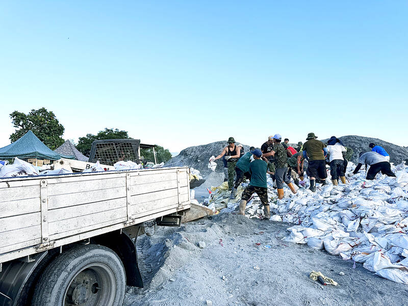
Photo: CNA
The first phase would be relocating vulnerable residents, including elderly people, disabled people, pregnant women and dialysis patients, in shelters and hospitals, he said.
The second phase would be mandatory evacuation of residents living in single-story houses, he said.
The third phase would be vertical evacuation, which means seeking shelter in an upper floor, he said.
The first two phases of evacuations are to begin when 24-hour cumulative rainfall hits 200mm, he said.
The third phase would be implemented when water levels in the Mataian River’s barrier lake reach 1m, he said, adding that air-raid-style alarms would be used to inform residents to vertically evacuate.
Chi urged all residents to prepare emergency kits with medications and personal essentials for survival.
Residents would be warned four hours before the mandatory evacuation begins, and those who refuse to leave after being advised to do so would face penalties, he said.
To ensure compliance, five-member oversight teams — comprising village heads, Hualien County officials, central government observers, police and firefighters — would travel by motorcycles to conduct door-to-door checks and advise every household during each phase of the evacuation, Chi said.
The total number of people to be evacuated is still being finalized by the local household registration office, he said.
Starting yesterday, the oversight teams have been assisting village leaders in confirming the actual number of residents and their planned method of evacuation, he said.
For the Mataian River, he said embankments on both sides have been raised to 5m, with sandbags deployed at potential overflow points.
Downstream dredging has been intensified to channel water and prevent flooding in low-lying areas, he added.

FUKUOKA SITUATION: Japanese media reported that the pathogen is expected to be identified by the summer, while the CDC downplayed the idea that it was hMPV A “mysterious cold-like illness” reported in Japan’s Fukuoka Prefecture does not seem to be a new disease, but Japanese authorities have been asked about the situation, the Centers for Disease Control (CDC) said yesterday. The Fukuoka Prefectural Medical Association on Wednesday told a news conference that a “mystery cold” that has become a hot topic on social media is “highly likely to be caused by some kind of viral infection,” Japan’s KBC News reported. “Many people are experiencing symptoms starting with a sore throat, followed by a runny nose, phlegm and a severe cough,” KBC News reported, citing association officials. Health authorities are

Nvidia Corp CEO Jensen Huang (黃仁勳) arrived in Taiwan yesterday ahead of upcoming AI and technology events, saying he plans to meet with clients and Taiwan Semiconductor Manufacturing Co Chairman C.C. Wei (魏哲家) during his visit. After landing at Taipei Songshan Airport, Huang posed for photos with fans and handed out Yakult drinks to reporters and supporters waiting at the scene, saying he has “a lot to do” during the trip. Asked about reports that Nvidia’s planned headquarters site in Taipei’s Beitou Shilin Technology Park could break ground on May 27, Huang said that if the company holds an event, he would
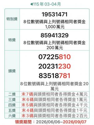
The Ministry of Finance this afternoon announced the winning numbers for the March-April uniform invoice lottery. The winning number for the NT$10 million (US$318,060) special prize is 19531471, and the winning number for the NT$2 million grand prize is 85941329. Three numbers were drawn for the NT$200,000 first prize: 07225810, 20231230 and 83518781. Those with receipts matching the last seven digits of any of the first-prize numbers will win the NT$40,000 second prize, while those matching the last six digits will win the NT$10,000 third prize. Those whose receipts match the last five digits of the first-prize numbers can claim the NT$4,000 fourth prize,

Taiwan Travelogue (臺灣漫遊錄), which earlier this week became the first Taiwanese novel to win the International Booker Prize, is to be adapted into a television series through a Taiwan-Japan coproduction, producer Chang Chen-yu (張辰漁) said yesterday. Chang, a producer at World Softest Production Film Co, wrote on Facebook that the company had been searching for projects with international appeal that retain a strong Taiwanese identity after colleagues and Japanese partners strongly recommended the novel. After reading the book, Chang said he immediately decided to pursue the screen rights. “A great story has the power to transcend time and borders, and connect countless people,”