The Legislative Yuan’s Internal Affairs Committee yesterday resolved to freeze NT$400 million (US$13.9 million) of the Ministry of the Interior’s budget for the issuance of new electronic identification cards (eIDs).
During the meeting, several legislators issued proposals to freeze a portion of the ministry’s budget for the eIDs, ranging from 10 to 50 percent. The ministry had initially budgeted NT$867.96 million for the cards.
“Since 2012 there have been information security concerns over plans for an electronic ID. These concerns are important. Once electronic ID cards are issued, there is no going back,” Democratic Progressive Party (DPP) Legislator Liu Shyh-fang (劉世芳) said, proposing that the committee first freeze half of the budget for the eIDs pending a detailed report on the cards.
DPP Legislator Huang Shih-chieh (黃世杰) said that issues related to information security handled by the Executive Yuan’s Department of Cyber Security would eventually become the responsibility of the planned Ministry of Digital Development.
The government should wait until this transition is enacted, rather than leave it to the Ministry of the Interior or the Department of Household Registration to deal with eID-related information security issues, he said.
“Legislators in every party have doubts about the new eIDs, and funds budgeted for the cards this year were frozen and never released. The ministry needs to present the committee with a detailed report for its approval,” DPP Legislator Shen Fa-hui (沈發惠) said.

The military has spotted two Chinese warships operating in waters near Penghu County in the Taiwan Strait and sent its own naval and air forces to monitor the vessels, the Ministry of National Defense (MND) said. Beijing sends warships and warplanes into the waters and skies around Taiwan on an almost daily basis, drawing condemnation from Taipei. While the ministry offers daily updates on the locations of Chinese military aircraft, it only rarely gives details of where Chinese warships are operating, generally only when it detects aircraft carriers, as happened last week. A Chinese destroyer and a frigate entered waters to the southwest
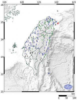
A magnitude 6.1 earthquake struck off the coast of Yilan County at 8:39pm tonight, the Central Weather Administration (CWA) said, with no immediate reports of damage or injuries. The epicenter was 38.7km east-northeast of Yilan County Hall at a focal depth of 98.3km, the CWA’s Seismological Center said. The quake’s maximum intensity, which gauges the actual physical effect of a seismic event, was a level 4 on Taiwan’s 7-tier intensity scale, the center said. That intensity level was recorded in Yilan County’s Nanao Township (南澳), Hsinchu County’s Guansi Township (關西), Nantou County’s Hehuanshan (合歡山) and Hualien County’s Yanliao (鹽寮). An intensity of 3 was

Japanese Prime Minister Sanae Takaichi’s comment last year on Tokyo’s potential reaction to a Taiwan-China conflict has forced Beijing to rewrite its invasion plans, a retired Japanese general said. Takaichi told the Diet on Nov. 7 last year that a Chinese naval blockade or military attack on Taiwan could constitute a “survival-threatening situation” for Japan, potentially allowing Tokyo to exercise its right to collective self-defense. Former Japan Ground Self-Defense Force general Kiyofumi Ogawa said in a recent speech that the remark has been interpreted as meaning Japan could intervene in the early stages of a Taiwan Strait conflict, undermining China’s previous assumptions

Taiwan Railways Corp (TRC) today announced that Shin Kong Mitsukoshi has been selected as the preferred bidder to operate the Taipei Railway Station shopping mall, replacing the current operator, Breeze Development Co Ltd. Among eight qualified firms that delivered presentations and were evaluated by a review committee, Shin Kong Mitsukoshi was ranked first, while Breeze was named the runner-up, the rail company said in a statement. Contract negotiations are to proceed in accordance with regulations, it said, adding that if negotiations with the top bidder fail, it could invite the second-ranked applicant to enter talks. Breeze in a statement today expressed doubts over