The budget for fiscal year 2019 to build a fleet of 60 missile-equipped 45-tonne fast-attack craft was yesterday cut by NT$200 million (US$6.48 million), from an initial NT$468 million, with lawmakers from across party lines saying that the navy should be more practical in its planning.
The funding cut came after a review of the navy’s budget by the Legislative Yuan’s Foreign Affairs and National Defense Committee.
At the committee’s meeting, Navy Chief of Staff Vice Admiral Lee Tsung-hsiao (李宗孝) said that design and testing of the fast-attack craft would begin next year, while preparations to produce the first four would not begin until 2021.
The production of new ships should depend on current needs, Chinese Nationalist Party (KMT) Legislator Johnny Chiang (江啟臣) said.
The navy has yet to provide a prototype for testing and simulation as it did with the earlier Tuo Jiang-class corvette, Chiang said, adding that the navy should not propose budgets for mass production without a prototype for trials and environmental tests.
The navy cannot guarantee that the total cost to produce the 60 vessels would be capped at the planned NT$31.6 billion, as it has not performed design and testing, the committee said.
Asked by KMT Legislator Ma Wen-chun (馬文君) how the navy would staff the vessels, Lee said that it would undergo a structural adjustment of personnel.
Following the retirement of ships from the amphibious landing branch, as well as minesweepers, the navy would have an excess of personnel to crew the new vessels, he said.
Unlike the Guang Hua VI fast-attack missile boat, the new vessels would conduct missions in various sea zones, he added.
Mass production plans would only be approved after the navy has conducted testing, the committee said.
NATIONAL SECURITY: Authorities are working to confirm the identities of the military personnel involved and investigating possible illegal conduct and regulatory violations Authorities are probing possible national security implications after Kinmen police and immigration officers on Sunday found a Chinese woman allegedly posing as a tourist while engaging in prostitution involving more than 10 military personnel. The woman, surnamed Chen (陳), has since been deported, authorities said, adding that investigators are still working to confirm the identities of those implicated, as the records only listed code names and aliases. The case stemmed from a report received by the Kinmen District Prosecutors’ Office on Friday last week from the Jinhu Precinct of the Kinmen County Police Bureau. On Sunday, police, along with the National Immigration

GLOBALGIVING: ‘ Caving to external pressure is not acceptable for an organization that has cultivated justice reform and human rights for 30 years,’ one NGO said A slew of non-government organizations (NGOs) have withdrawn from the GlobalGiving fundraising platform after it announced it would use “Chinese Taipei” instead of “Taiwan” from next month. The Taiwan Good Rice Association wrote on Facebook on Friday that it was informed on April 28 via a teleconference call of the change, which was made because the platform wanted to operate in China. Taiwan Good Rice is to terminate all cooperative relationships with GlobalGiving in response to the platform’s “unilateral and non-negotiable” decision to remove references to Taiwan, the NGO said. “Taiwan is in the official name of Taiwan Good Rice Association and the

HEAVY WEATHER: Typhoon Jangmi is due to crash straight into the Ryukyus as airlines look to shift flights to larger aircraft or cancel flights to Okinawa entirely Taiwan’s international air carriers announced flight adjustments over the weekend as Typhoon Jangmi is forecast to hit the Ryukyu Islands today and tomorrow. The Central Weather Administration (CWA) upgraded Jangmi from a tropical storm to a typhoon at 8am yesterday, with the eye located 580km south of Naha city. It was moving north at 19kph. Today, China Airlines’ CI-120, CI-121, CI-122 and CI-123 flights between Taoyuan and Naha, Okinawa, have been canceled as well as CI-132 and CI-133 between Kaohsiung and Naha. EVA Air’s BR-112, BR-113, BR-186 and BR-185 flights between Taoyuan and Naha are also canceled. Low-cost carrier Tigerair Taiwan canceled IT-230,
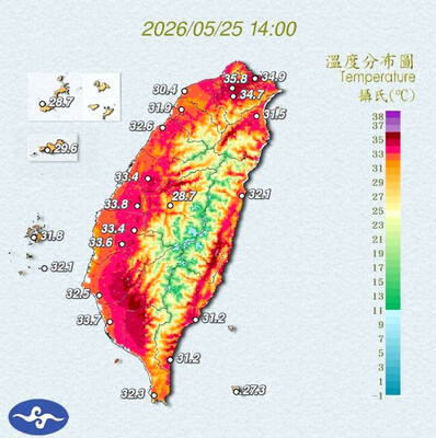
STAY COOL: The HPA recommended that people stay hydrated, use air-conditioning or fans while indoors, wear loose-fitting clothes and walk in the shade while outdoors Employers must implement measures such as installing cooling equipment, and providing drinking water and rest breaks for outdoor workers starting from Monday next week, the Taipei Department of Labor said on Sunday. Employers who fail to comply could face fines of NT$30,000 to NT$300,000 under the Occupational Safety and Health Act (職業安全衛生法), the department said. Businesses in Taipei employing fewer than 100 workers, as well as registered self-employed workers with labor insurance coverage, could receive on-site assessments and guidance from occupational safety consultants to help them apply for central government subsidies to implement or improve heat-protection measures, it said. Under the Ministry of