The nation’s first domestically developed satellite, Formosat-5, has taken images at the resolution it was designed to deliver, but only “when weather conditions are good,” Ministry of Science and Technology (MOST) officials said yesterday, adding it has completed its mission of capturing satellite images of Taiwan.
The satellite was launched from Vandenberg Air Force Base in California on Aug. 25 last year, but the first images it transmitted back in September last year were fuzzy and marred by light spots.
Since then, the National Space Organization (NSPO) has been working to improve its image quality using image processing software and by adjusting the satellite’s altitude, angle and the temperature of its imaging device.
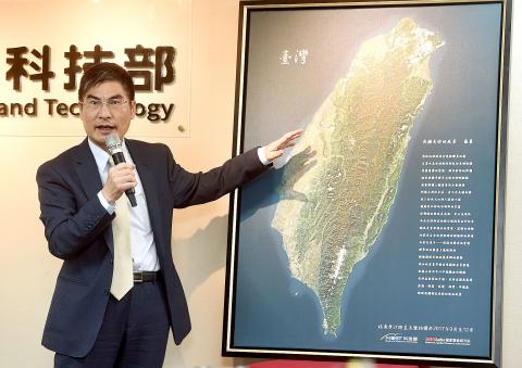
Photo: Chien Jung-fong, Taipei Times
At a news conference in Taipei yesterday, project director Chang Ho-pen (張和本) said the satellite has achieved the resolution it was designed to produce — 2m for black-and-white images and 4m for color images — when the weather permits.
“For example, the satellite images taken from above China and from above California can be very different when the former has serious air pollution,” Chang said.
Yet, the NSPO has not quantified what weather conditions would allow the satellite to transmit images at its default resolution, he added.
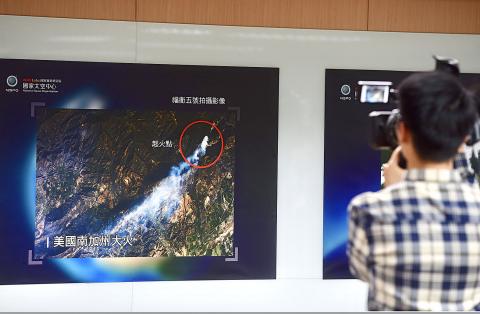
Photo: Chien Jung-fong, Taipei Times
The satellite’s images have already proven sufficient in supporting the nation’s disaster prevention missions, and would be available on the organization’s Web site from September, he said, adding that the US, Japan, Russia and Australia have expressed an interest in purchasing the images.
Asked if Formosat-5’s performance has achieved the ministry’s objectives, Chang said “yes,” while Minister of Science and Technology Chen Liang-gee (陳良基) gave a more reserved response.
The imaging capabilities of Formosate-5 have surpassed those of Formosat-2, which has a 2m resolution for monochromatic images and 8m for colored ones, Chen said.
However, when compared with the US Army’s stricter requirements, it only achieves a 3m resolution for black-and-white images and 5m for colored ones, he said.
As the NSPO is planning to launch one satellite per year in the following 10 years, it will pay more attention to the mechanical adjustment and microwave sensing capabilities of satellites, Chen said.
Meanwhile, Formosat-5, which passes over the same spot on Earth every two days, has finished taking remote images of Taiwan during its orbits between September and December last year, he said.
The ministry presented a complete satellite image of Taiwan to President Tsai Ing-wen (蔡英文) yesterday, with Tsai promising to support its space programs, Chen added.
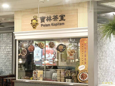
POLAM KOPITIAM CASE: Of the two people still in hospital, one has undergone a liver transplant and is improving, while the other is being evaluated for a liver transplant A fourth person has died from bongkrek acid poisoning linked to the Polam Kopitiam (寶林茶室) restaurant in Taipei’s Far Eastern Sogo Xinyi A13 Department Store, the Ministry of Health and Welfare said yesterday, as two other people remain seriously ill in hospital. The first death was reported on March 24. The man had been 39 years old and had eaten at the restaurant on March 22. As more cases of suspected food poisoning involving people who had eaten at the restaurant were reported by hospitals on March 26, the ministry and the Taipei Department of Health launched an investigation. The Food and

The long-awaited Taichung aquarium is expected to open next year after more than a decade of development. The building in Cingshui District (清水) is to feature a large ocean aquarium on the first floor, coral display area on the second floor, a jellyfish tank and Dajia River (大甲溪) basin display on the third, a river estuary display and restaurant on the fourth, and a cafe and garden on the fifth. As it is near Wuci Fishing Port (梧棲漁港), many are expecting the opening of the aquarium to bring more tourism to the harbor. Speaking at the city council on Monday, Taichung City Councilor
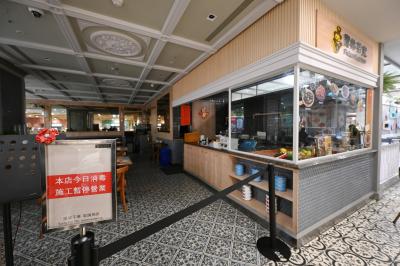
A fourth person has died in a food poisoning outbreak linked to the Xinyi (信義) branch of Malaysian restaurant chain Polam Kopitiam (寶林茶室) in Taipei, Deputy Minister of Health and Welfare Victor Wang (王必勝) said on Monday. It was the second fatality in three days, after another was announced on Saturday. The 40-year-old woman experienced multiple organ failure in the early hours on Monday, and the family decided not to undergo emergency resuscitation, Wang said. She initially showed signs of improvement after seeking medical treatment for nausea, vomiting and diarrhea, but her condition worsened due to an infection, he said. Two others who

Taiwanese should be mindful when visiting China, as Beijing in July is likely to tighten the implementation of policies on national security following the introduction of two regulations, a researcher said on Saturday. China on Friday unveiled the regulations governing the law enforcement and judicial activities of national security agencies. They would help crack down on “illegal” and “criminal” activities that Beijing considers to be endangering national security, according to reports by China’s state media. The definition of what constitutes a national security threat in China is vague, Taiwan Thinktank researcher Wu Se-chih (吳瑟致) said. The two procedural regulations are to provide Chinese