A lawmaker yesterday proposed a trial voyage to China before the "small three links" (
With only three weeks remaining before the opening of direct trade, transportation and communication ties between Kinmen and Matsu and Xiamen and Fuzhou respectively, lawmakers held a press conference at the legislature yesterday to express their concern about a lack of response from Chinese authorities over the matter.
"Taiwan has been carried away with its one-sided enthusiasm. We don't know what will happen if our ships arrive there on Jan. 1 if [the Chinese government] continues to remain silent," said Chen Ching-pao (
"I hope the `small three links' will open a new and better chapter in cross-strait relations, instead of creating more tension," he said.
Citing his own experience, Chen said he led a medical group to Xiamen in November to pave the way for the opening of the links.
"Though our team was received by the Xiamen authorities, they were unwilling to provide any concrete measures regarding medical assistance in case of an emergency," he said.
Chen said that Mainland Affairs Council Chairwoman Tsai Ing-wen (
The experimental trip is tentatively scheduled to take place between Dec. 25 and Dec. 27, and will go between Liaoluo Harbor (料羅) on Kinmen and Heping Harbor (和平) in Xiamen, Chen said.
"If and how the test voyage will take place will hinge upon China's response," he noted.
While preparations have been under way in Taiwan for the opening of the "small three links," China has so far not ordered the authorities in Fujian Province to take reciprocal measures.
The only message conveyed to Taiwan fom China on the matter was from Chinese Premier Zhu Rongji (
Analysts have said that China's reluctance to communicate with Taiwan on the matter was because the mainland leadership does not want to appear to be softening its stance on the "one China" issue.
Beijing has continued to insist on its "one China" principle as a condition for any cross-strait dialogue.
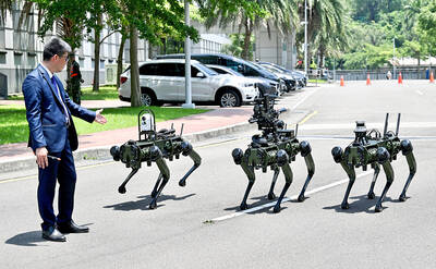
The National Chungshan Institute of Science and Technology yesterday showcased its locally developed variants of the Vision 60 robotic patrol dog, which it plans to deploy on the nation’s outlying territories in the South China Sea. The variants were produced under the Joint Lab project — created by the institute and domestic companies — and assembled with domestically produced motors, lenses and artificial intelligence (AI) systems alongside licensed tech from the US, Missile and Rocket Systems Research Division deputy director Jen Kuo-kang (任國光) told the media event at a military base in Taipei’s Dazhi (大直) area. Taiwan has built up its strengths

RIGHT DIRECTION: Taiwan’s efforts to prevent forced labor include a proposal to ‘fully prohibit’ employers from withholding workers’ documents, an official said Taiwan is to establish a mechanism to restrict imports of goods linked to forced labor, the Executive Yuan said yesterday, after the US proposed imposing additional tariffs on Taiwanese goods over labor concerns. “The Ministry of Labor and the Ministry of Economic Affairs are to establish an interministerial review procedure,” Executive Yuan spokesperson Michelle Lee (李慧芝) said at a news briefing in Taipei. “The government is to use the Foreign Trade Act [貿易法] as the legal basis to restrict imports of goods produced with forced labor” and bring its supply chain governance more in line with international standards on human rights, resilience
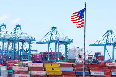
NOT IMMEDIATE: Taiwan has a chance to appeal the proposed 10 percent tariff before it starts, while other countries face a 12.5 percent tariff from the trade office Taiwan is among 60 economies determined by the US to have failed to impose or enforce a ban on the importation of goods produced with forced labor, according to a notice released on Tuesday by the Office of the US Trade Representative (USTR), which proposed imposing an additional 10 percent or more tariff on them. The USTR in a statement said that following an investigation, it had determined under Section 301 of the Trade Act of 1974 that the failure of the 60 economies to impose and effectively enforce a prohibition on the importation of goods produced with forced labor is
TIT-FOR-TAT: The US allegedly revoked the visa of a Chinese national working at Xinhua News Agency in the US in response to Beijing’s expulsion of Vivian Wang The Presidential Office yesterday condemned China for expelling a New York Times correspondent from Beijing following the newspaper’s interview with President William Lai (賴清德), saying the move highlighted Beijing’s suppression of press freedom and its threat to international news media. Taiwan has noted a series of recent incidents in which Beijing used similar tactics to “threaten and pressure international media outlets and journalists,” Presidential Office spokeswoman Karen Kuo (郭雅慧) said in a statement. “This concerns not only press freedom and freedom of expression, but also the safety of journalists, and Taiwan and relevant partners are paying close attention to the situation,” she