Jade Mountain Main Peak route is a popular hiking track, but there are limited spaces available in the Paiyun Mountain Lodge, and it can be difficult to obtain one through the lot system: anyone wanting to climb up to the peak needs a bit of luck on their side. In order to make it easy for people to get more acquainted with the terrain in the Yushan National Park, the administrative office has put a 3D map app of the area, available for download, on its official Web site. When the app is downloaded and opened, it is possible to browse the area’s topography, and even use a special feature to virtually traverse the terrain, from the trailhead all the way up to the main peak. Following the lines of the changes in the terrain allows hikers to carry out a little readiness training before they set off, to ensure that they can hike up safely.
According to the office, since the mountain was opened up to the public, many people have wanted to try their hand at ascending it, but mountain climbing can be dangerous. The Jade Mountain 3D map uses aerial radar imaging to map out the direction and altitude changes of the hiking tracks in the mountains, and to record the various features and facilities along the way, including the trailheads and the Paiyun Mountain Lodge.
Going along the Jade Mountain Main Peak route, up from the trailhead to the Paiyun Mountain Lodge, you can see the Daciaobi (Great Precipice) just past the 7km mark, with the lodge appearing at the 8.5km mark. If you proceed west from here there is the Jade Mountain West Peak, and hiking another 2.4km up over a series of switchbacks, you will arrive at the Jade Mountain Main Peak.
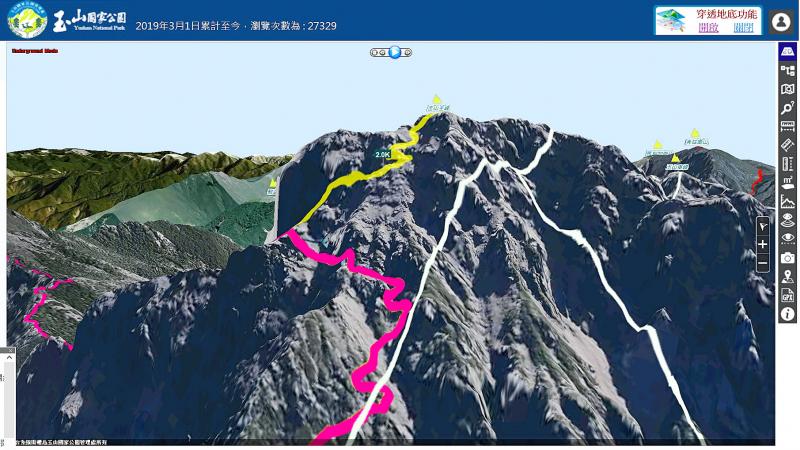
Photo: Liu Pin-chuan, Liberty Times 照片:自由時報記者劉濱銓
Using the Jade Mountain 3D map, avid hikers will be able to find out the actual trail conditions before they set off on their trip. The resource is also available to anyone to go online and have at their fingertips the ability to virtually experience the mountain. They can also browse through the “720-degree panoramic view” and enjoy 16 scenic spots in the park, including the trailhead, to get a feel for the scenery. In the future, this system will also be applied to the conservation of wild animals and forests and to the management of the national park. Not only will it make information about the area readily available, it will also facilitate more efficient management of the area.
(Translated by Paul Cooper, Taipei Times)
玉山主峰線是熱門登山路線,但受限排雲山莊床位與中籤機率,想登玉山還需一些運氣。玉山國家公園管理處為讓民眾能多認識玉山園區環境,在官網推出3D圖台,只要下載並開啟圖台,就能線上瀏覽玉山園區山勢,還能透過虛擬「步道飛覽」功能,從登山口直攻玉山主峰,掌握沿途山勢變化,讓山友行前做好鍛鍊與功課,確保登山安全。
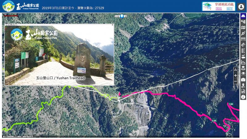
Photo: Liu Pin-chuan, Liberty Times 照片:自由時報記者劉濱銓
玉管處表示,隨著山林開放,許多民眾都想嘗試登山,但可能因對山區環境的不熟悉,貿然登山容易發生危險,因此推出「玉山3D圖台」,該系統透過空中雷達攝影,建立山區山脈走向與起伏,就連沿途相關設施也有記錄,例如玉山登山口、玉山排雲山莊等。
其中就蒐羅玉山主峰線,從登山口一路到排雲山莊,在七公里多可見大峭壁,在八.五公里則是排雲山莊,往西走就是玉山西峰,往山區陡上二.四公里,經過之字形路線,就是玉山主峰頂。
山友透過玉山3D圖台,不只能在登山前先行了解現場實境,一般民眾也能藉此資源,上網動動手指,就能虛擬體驗玉山,還能開啟遊憩資訊「720度環景影像」圖層,欣賞玉山登山口等園區十六處景點,認識現場實地影像,未來這套系統也會結合野生動物、森林保育,以及國家公園經營管理,除讓山林資訊更容易取得,也能提升管理效率。
(自由時報)
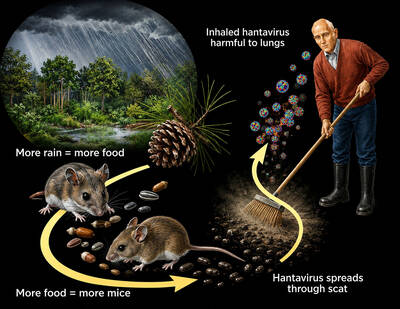
An outbreak aboard a cruise ship of a rare rodent-borne illness called hantavirus has left three passengers dead and sickened others, but global health officials say the risk to the general public remains low because the germ does not easily spread between people. “This is not the next COVID, but it is a serious infectious disease,” said Maria Van Kerkhove, director of epidemic and pandemic preparedness at the World Health Organization (WHO). “Most people will never be exposed to this.” The virus usually spreads when people inhale contaminated residue of rodent droppings. Hantaviruses have been around for centuries and are thought to

Have you ever wondered how people navigate the world when they can’t see a map? For individuals with visual impairments, conventional maps are nearly impossible to use. This is where tactile maps come in — essential tools that allow people to “see” the world through touch. A tactile map is specially designed with raised lines, textures, and symbols to represent geographical features such as roads, rivers, and buildings. Users explore it with their fingertips. However, these maps are not exclusively for people with visual disabilities. They serve as valuable multisensory learning tools that enhance spatial understanding for everyone, making

A: In early May, there were concerts by Icyball, Chyi Yu, Korea’s EXO and Japan’s Anisama, but I missed them all. What a shame. B: That’s OK. There are shows coming up by various artists, including Power Station, Accusefive, Japanese singer Mika Nakashima, Chinese-Icelandic jazzer Laufey, and even Singaporean diva Stefanie Sun. A: After a 12-year hiatus, Stefanie is finally returning to Taipei again. B: In late May, there will be more shows by Crowd Lu, WeiBird, Korea’s Donghae, 2AM, EXID, and Thailand’s BUS. A: The Thai boyband is so popular. It looks like “T-pop” is catching up with J-pop

Since 2005, the third Monday in January has come to be known as “Blue Monday.” In other words, that day is believed to be the most depressing day of the year. This concept seems logical at first. After all, Monday marks the start of the school or workweek after two days of rest and fun. Also, blue is a color that is often associated with sadness. Furthermore, in many parts of the world, January is a time when the weather is cold, rainy, and gloomy. But is there any scientific proof that this January day is truly sadder than any of