Large drones that flew over Copenhagen airport for hours and caused it to shut down constituted the “most serious attack on Danish critical infrastructure” to date, Danish Prime Minister Mette Frederiksen said yesterday.
Airports in Copenhagen and Oslo reopened early yesterday, hours after unidentified drones in their airspace caused dozens of flights to be diverted or canceled, disrupting thousands of passengers.
“This is part of the development we have recently observed with other drone attacks, airspace violations and cyberattacks targeting European airports,” Frederiksen said in a statement.
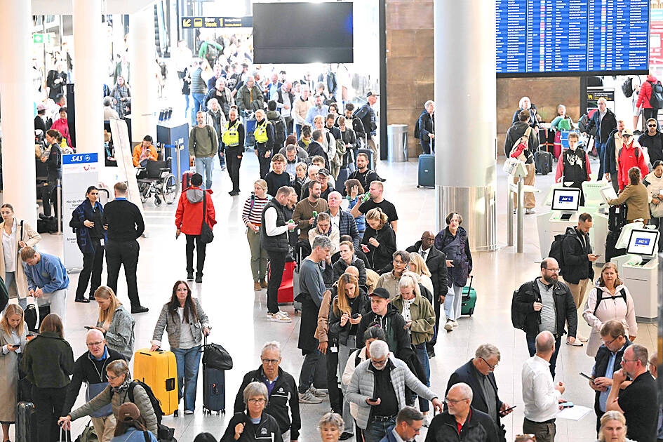
Photo: AFP
She referred to similar drone incidents in Poland and Romania, and the violation by Russian fighter jets of Estonia’s airspace. The governments of Poland, Estonia and Romania have pointed the finger at Moscow, which has brushed off the allegations.
Frederiksen told Danish broadcaster DR she could “not rule out” that Russia was behind the drone activity.
Moscow denied involvement, with Kremlin spokesman Dmitry Peskov criticizing her remarks as “unfounded accusations.”
However, NATO Secretary-General Mark Rutte said it was “too early to say” whether the drone flights were linked to recent Russian violations of the alliance’s airspace.
“The Danes are at this moment exactly assessing what happened, to make sure what is behind this. We are in very close contact on this. So it is too early to say,” Rutte said, adding that he had spoken to the Danish prime minister.
Ukrainian President Volodymyr Zelenskiy on X denounced what he said was a Russian violation of Denmark’s airspace.
Danish police said they had been unable to identify the drone operator.
“The number, size, flight patterns, time over the airport. All this together ... indicates that it is a capable actor. Which capable actor, I do not know,” Copenhagen Chief Police Inspector Jens Jespersen told reporters.
“It was an actor that had the capacity, the will and the tools to make their presence known,” he said.
Danish intelligence said the Scandinavian country was facing a “high threat of sabotage.”
“Someone may not necessarily want to attack us, but rather stress us out and see how we react,” said Flemming Drejer, director of operations at Denmark’s intelligence service PET.
Jespersen said “several large drones” flew over Copenhagen Airport for more than three hours on Monday evening.
Police decided not to shoot down the drones for safety reasons.
“You have to think very carefully before starting to try to take down such big drones,” Jespersen said.
If they were to fall to the ground, “there are planes with people, fuel and also housing on several sides of the airport.”
Jespersen said it was not known where the drones were being controlled from, but that it could have been from many kilometers away.
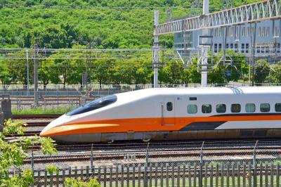
A signaling system malfunction disrupted high-speed rail (HSR) services beginning at 8am today, with trains temporarily reduced to three northbound and three southbound trains per hour as authorities conduct inspections. The malfunction occurred on a section of track in Miaoli County during pre-operation checks early this morning, forcing northbound and southbound trains to use a single track, the HSR operator said. The regular schedule has been replaced with three hourly trains offering only nonreserved seating in each direction, stopping at every station, it said, adding that business class cars would still have reserved seating. Departures from terminal stations are scheduled at the top

Taiwan is still in the process of assessing the possibility of recruiting workers from Eswatini, the Ministry of Foreign Affairs said yesterday, adding that its goal is to help Eswatini upgrade its vocational training centers. If there are plans to recruit workers from Eswatini, safeguarding national security, protecting public health and ensuring the employment rights of Taiwanese would be prerequisites, Department of West Asian and African Affairs Director-General Yen Chia-liang (顏嘉良) told a news conference. Key considerations would also include filling labor shortages in specific industries, and fostering bilateral professional and technical exchanges, he said. Yen was asked about the progress of labor
A US uncrewed surface vessel (USV) encountered multiple Chinese warships during an autonomous transit of the Taiwan Strait, US defense company Seasats said in a statement on Wednesday. Seasats announced that a Lightfish USV had completed the first autonomous transit of the Taiwan Strait. Over five days, the USV traversed the entire length of the Strait while constantly monitoring surface vessel traffic, the company said. The Lightfish encountered multiple Chinese warships, one of which was a Chinese People’s Liberation Army Navy (PLAN) Type 056 corvette, it said. The Chinese vessels were operating “well within Taiwan’s exclusive economic zone without transmitting their identity via the
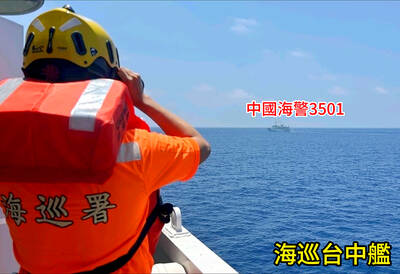
VERBOSE VESSELS: A CGA cutter and a China Coast Guard exchanged verbal barbs for more than a day in Taiwanese-controlled waters before the Chinese vessel left The Taiwanese and Chinese coast guards had a standoff near the strategically located Pratas Islands (Dongsha Islands, 東沙群島) in the north of the South China Sea, the Coast Guard Administration (CGA) said yesterday. The two sides engaged in intense radio exchanges over sovereignty claims during the 33-hour standoff. China Coast Guard vessel 3501 eventually left the restricted waters, 26.6 nautical miles (49.2km) west of the Pratas Islands, at 5pm yesterday, the CGA said. Lying approximately between southern Taiwan and Hong Kong, the Taiwan-controlled Pratas are seen by some security experts as vulnerable to Chinese attack due to their distance — more than