People planning to travel during the Lunar New Year holiday, which runs from tomorrow to Wednesday next week, should be alert to changes in temperatures, the Central Weather Administration (CWA) said yesterday.
Starting today, chances of rain are high in northern Taiwan due to the arrival of a continental cold mass and a rain front moving from southeast China, said Lo Ya-yin (羅雅尹), a senior specialist at the bureau’s weather forecast center.
Temporary showers are forecast in other parts of the nation, she said.
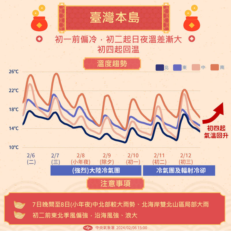
Photo courtesy of the Central Weather Administration
From tomorrow to Lunar New Year’s Eve on Friday, chances of rain are high nationwide, with cold and rainy weather forecast north of central Taiwan, in southern Taiwan, and Yilan, Hualien and Taitung counties.
“Motorists should be alert as the rain would cause roads to be slippery. Travelers heading to the outlying islands should pay attention to changes in ferry services due to high wind and sea waves during this period,” Lo said.
On Saturday, lower temperatures are forecast in northern Taiwan, and Yilan and Hualien counties, as the nation would remain under the influence of the continental cold wave, Lo said.
In other regions, daytime and evening temperatures would remain low, she said.
Cloudy skies are forecast for the west coast on Saturday as rains are expected to ease, while chances of rain in the coastal and mountainous areas in the east coast remain high, she said.
From Sunday to Monday, cloudy to sunny skies are forecast in most parts of the nation, with isolated showers expected in some parts of the east coast, Lo said.
However, under the influence of the cold air mass and radiative cooling effects, temperatures would remain low in the morning and evening, with marked differences in daytime and nighttime temperatures in central and southern Taiwan, she said.
From Tuesday to Wednesday next week, daytime temperatures would rise significantly as the cold air mass weakens, but daytime and nighttime temperatures would remain low, Lo said.
Differences in temperatures between day and night along the west coast would still be large, she said.
Cloudy to sunny skies are forecast for most parts of the nation, with isolated showers forecast along the east coast, Lo said.
“When the weather gets warmer, fog could appear in the west coast, and visibility in Kinmen and Lienchiang County (Matsu) is likely to be low. Travelers would need to pay attention to changes in flight services to outlying islands,” she said.

FIREPOWER: On top of the torpedoes, the military would procure Kestrel II anti-tank weapons systems to replace aging license-produced M72 LAW launchers Taiwan is to receive US-made Mark 48 torpedoes and training simulators over the next three years, following delays that hampered the navy’s operational readiness, the Ministry of National Defense’s latest budget proposal showed. The navy next year would acquire four training simulator systems for the torpedoes and take receipt of 14 torpedoes in 2027 and 10 torpedoes in 2028, the ministry said in its budget for the next fiscal year. The torpedoes would almost certainly be utilized in the navy’s two upgraded Chien Lung-class submarines and the indigenously developed Hai Kun, should the attack sub successfully reach operational status. US President Donald Trump
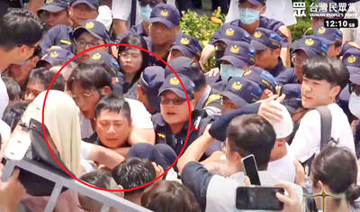
TPP RALLY: The clashes occurred near the Chiang Kai-shek Memorial Hall on Saturday at a rally to mark the anniversary of a raid on former TPP chairman Ko Wen-je People who clashed with police at a Taiwan People’s Party (TPP) rally in Taipei on Saturday would be referred to prosecutors for investigation, said the Ministry of the Interior, which oversees the National Police Agency. Taipei police had collected evidence of obstruction of public officials and coercion by “disorderly” demonstrators, as well as contraventions of the Assembly and Parade Act (集會遊行法), the ministry said in a statement on Sunday. It added that amid the “severe pushing and jostling” by some demonstrators, eight police officers were injured, including one who was sent to hospital after losing consciousness, allegedly due to heat stroke. The Taipei
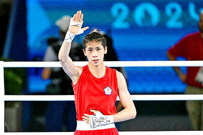
NO LIVERPOOL TRIP: Taiwan’s Lin Yu-ting, who won a gold medal in the boxing at the Paris Olympics, was embroiled in controversy about her gender at that event Taiwanese boxer Lin Yu-ting (林郁婷) will not attend this year’s World Boxing Championships in Liverpool, England, due to a lack of response regarding her sex tests from the organizer, World Boxing. The national boxing association on Monday said that it had submitted all required tests to World Boxing, but had not received a response as of Monday, the departure day for the championships. It said the decision for Lin to skip the championships was made to protect its athletes, ensuring they would not travel to the UK without a guarantee of participation. Lin, who won a gold medal in the women’s 57kg boxing

The US has revoked Taiwan Semiconductor Manufacturing Co’s (TSMC, 台積電) authorization to freely ship essential gear to its main Chinese chipmaking base, potentially curtailing its production capabilities at that older-generation facility. American officials recently informed TSMC of their decision to end the Taiwanese chipmaker’s so-called validated end user (VEU) status for its Nanjing site. The action mirrors steps the US took to revoke VEU designations for China facilities owned by Samsung Electronics Co and SK Hynix Inc. The waivers are set to expire in about four months. “TSMC has received notification from the US Government that our VEU authorization for TSMC Nanjing