A plum rain season weather front yesterday caused a flash food in Changhua County, but provided slight relief from the water shortage that Taiwan has been experiencing since last month.
As of 3:26pm yesterday, Changhua County’s Sioushuei Township (秀水) had accumulated 195mm of rain, the most in the nation, Central Weather Bureau data showed.
Nine of the nation’s top 10 accumulated rainfall volumes were recorded at the bureau’s observation stations in Changhua, bureau data showed.
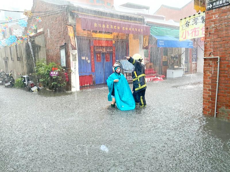
Photo: provided by the Changhua County Fire Deparment via CNA
Changhua’s Lugang Matsu Temple (鹿港天后宮) was flooded.
Television news footage showed people in Lukang Old Street (鹿港老街) wading through knee-high water and cleaning debris after the water receded.
Despite experiencing substantial rainfall, Changhua does not have a reservoir to store rainwater, Taiwan Water Corp (台灣自來水) said.
As such, the company would still enforce water rationing, where residents in Changhua City and other townships have their water cut off for two days of the week, it said.
Bureau forecaster Lin Ping-yu (林秉煜) said that the rain front would affect the nation until tomorrow, with high chances of showers or thundershowers along the west coast and in Yilan, Hualien and Taitung counties.
People should also beware of possible disasters caused by intense rainfall over a short period, he said.
The weather would remain unstable today, but the rain would be less intense than yesterday, he said, adding that it would rain less tomorrow than today.
The front would gradually move north on Wednesday, but the chance of showers or thundershowers along the west coast would remain, Lin said.
Cloudy skies with afternoon thundershowers are forecast for the rest of the nation, he added.
On Thursday and Friday, a southwesterly wind would affect the nation, with a high chance of showers in some regions in central and southern Taiwan, Lin said.
Cloudy skies are forecast for the rest of the nation, although some mountainous areas would have thundershowers, he said.
Another rain front is expected to approach Taiwan on Saturday, bringing rain across the nation, he said.
However, the front would be moving faster than yesterday’s, so there would be less accumulated rainfall, he said.
In other news, a tropical depression off the east coast of the Philippines could soon turn into the Northwest Pacific’s third tropical storm, which would be called Choi-wan.
As of 2pm, the tropical depression was traveling at 12kph, bureau data showed.
Moving northwest, it is forecast to be upgraded by tomorrow or Wednesday, Lin said, adding that it would travel near the north coast of Luzon Island by Thursday.
Although it is unlikely to affect Taiwan directly, the bureau is monitoring to see whether the atmospheric environment changes as it moves, he said.
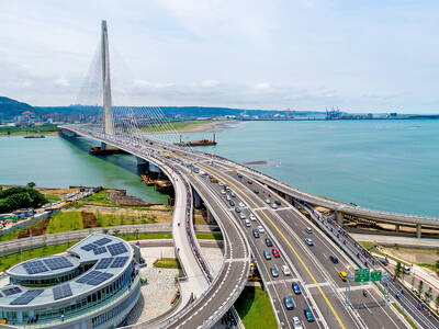
The Ministry of Transportation and Communications yesterday inaugurated the Danjiang Bridge across the Tamsui River in New Taipei City, saying that the structure would be an architectural icon and traffic artery for Taiwan. Feted as a major engineering achievement, the Danjiang Bridge is 920m long, 211m tall at the top of its pylon, and is the longest single-pylon asymmetric cable-stayed bridge in the world, the government’s Web site for the structure said. It was designed by late Iraqi-British architect Zaha Hadid. The structure, with a maximum deck of 70m, accommodates road and light rail traffic, and affords a 200m navigation channel for boats,

Taiwan Semiconductor Manufacturing Co (TSMC, 台積電), the world’s largest foundry service provider, yesterday said that global semiconductor revenue is projected to hit US$1.5 trillion in 2030, after the figure exceeds US$1 trillion this year, as artificial intelligence (AI) demand boosts consumption of token and compute power. “We are still at the beginning of the AI revolution, but we already see a significant impact across the whole semiconductor ecosystem,” TSMC deputy cochief operating officer Kevin Zhang (張曉強) said at the company’s annual technology symposium in Hsinchu City. “It is fair to say that in the past decade, smartphones and other mobile devices were

US-CHINA SUMMIT: MOFA welcomed US reassurance of no change in its Taiwan policy; Trump said he did not comment when Xi talked of opposing independence US President Donald Trump yesterday said he has not made a decision on whether to move forward with a major arms package for Taiwan after hearing concerns about it from Chinese President Xi Jinping (習近平). Trump’s comments on Taiwan came as he flew back to Washington after wrapping up critical talks in which both leaders said important progress was made in stabilizing US-China relations even as deep differences persist between the world’s two biggest powers on Iran and Taiwan. “I will make a determination,” Trump said, adding: “I’ll be making decisions. But, you know, I think the last thing we need right

TAIWAN ISSUE: US treasury secretary Scott Bessent said on the first day of meetings that ‘it wouldn’t be a US-China summit without the Taiwan issue coming up’ There were no surprises on the first day of the summit between US President Donald Trump and Chinese President Xi Jinping (習近平), the Mainland Affairs Council (MAC) said yesterday, as the government reiterated that cross-strait stability is crucial to the Asia-Pacific region, as well as the world. As the two presidents met for a highly anticipated summit yesterday, Chinese state media reported that Xi warned Trump that missteps regarding Taiwan could push their two countries into “conflict.” Trump arrived in China with accolades for his host, calling Xi a “great leader” and “friend,” and extending an invitation to visit the White House