China’s first landing of a plane on one of its new island runways in the South China Sea shows Beijing’s facilities in the disputed region are being completed on schedule and military flights will inevitably follow, foreign officials and analysts said.
China’s increasing military presence in the disputed sea could effectively lead to a Beijing-controlled air defense zone, they said, ratcheting up tensions with other claimants and with the US.
Chinese Ministry of Foreign Affairs officials on Saturday said that a test flight by a civilian plane landed on an artificial island built in the Spratly Islands (Nansha Islands, 南沙群島), the first time Beijing has used a runway in the area.
Vietnam launched a formal diplomatic protest while Philippines Ministry of Foreign Affairs spokesman Charles Jose said Manila was planning to do the same.
Both nations have claims to the area that overlap with China and Taiwan.
“That’s the fear, that China will be able take control of the South China Sea and it will affect the freedom of navigation and freedom of overflight,” Jose said.
In Washington, US Department of State spokesman John Kirby on Monday said China’s landing of the plane “raises tensions and threatens regional stability.”
US Senator John McCain, the chairman of the Senate Armed Services Committee, criticized US President Barack Obama’s administration for delaying further “freedom of navigation” patrols within 12 nautical miles (22.2km) of the islands built by China.
McCain said that the lack of US action was allowing China to continue to “pursue its territorial ambitions” in the region.
He said the Obama administration was “either unable to manage the complexities of interagency national security decisionmaking or simply too risk averse to do what is necessary to safeguard the rules-based order in the Asia-Pacific.”
China has been building runways on the artificial islands for more than a year, and the plane’s landing was not a surprise.
The runway on Fiery Cross Reef (Yongshu Reef, 永暑礁) is 3km long and is one of three China was constructing on artificial islands built up from seven reefs and atolls in the Spratlys.
The runways would be long enough to handle long-range bombers and transport craft as well as China’s best jet fighters, giving them a presence deep into the maritime heart of Southeast Asia.
Chinese officials have repeatedly said that the new islands would be mostly for civilian use.
However, military landings on the islands were now “inevitable,” said Leszek Buszynski, a visiting fellow at the Australian National University’s Strategic and Defence Studies Centre in Canberra.
An air defense zone, while unlikely soon, was feasible and possible in future once China builds up its air strength, he said.
“The next step will be, once they’ve tested it with several flights, they will bring down some of their fighter air power — SU-27s and SU-33’s — and they will station them there permanently. That’s what they’re likely to do,” he said.
Ian Storey, a South China Sea expert at Singapore’s ISEAS Yusof Ishak Institute, said he expected tensions to worsen as China used its new facilities to project power deeper into the South China Sea.
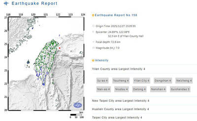
A magnitude 7.0 earthquake struck off Yilan at 11:05pm yesterday, the Central Weather Administration (CWA) said. The epicenter was located at sea, about 32.3km east of Yilan County Hall, at a depth of 72.8km, CWA data showed There were no immediate reports of damage. The intensity of the quake, which gauges the actual effect of a seismic event, measured 4 in Yilan County area on Taiwan’s seven-tier intensity scale, the data showed. It measured 4 in other parts of eastern, northern and central Taiwan as well as Tainan, and 3 in Kaohsiung and Pingtung County, and 2 in Lienchiang and Penghu counties and 1

FOREIGN INTERFERENCE: Beijing would likely intensify public opinion warfare in next year’s local elections to prevent Lai from getting re-elected, the ‘Yomiuri Shimbun’ said Internal documents from a Chinese artificial intelligence (AI) company indicated that China has been using the technology to intervene in foreign elections, including propaganda targeting Taiwan’s local elections next year and presidential elections in 2028, a Japanese newspaper reported yesterday. The Institute of National Security of Vanderbilt University obtained nearly 400 pages of documents from GoLaxy, a company with ties to the Chinese government, and found evidence that it had apparently deployed sophisticated, AI-driven propaganda campaigns in Hong Kong and Taiwan to shape public opinion, the Yomiuri Shimbun reported. GoLaxy provides insights, situation analysis and public opinion-shaping technology by conducting network surveillance
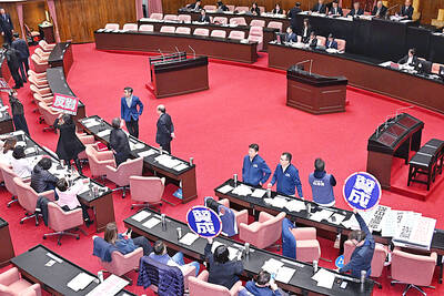
‘POLITICAL GAME’: DPP lawmakers said the motion would not meet the legislative threshold needed, and accused the KMT and the TPP of trivializing the Constitution The Legislative Yuan yesterday approved a motion to initiate impeachment proceedings against President William Lai (賴清德), saying he had undermined Taiwan’s constitutional order and democracy. The motion was approved 61-50 by lawmakers from the main opposition Chinese Nationalist Party (KMT) and the smaller Taiwan People’s Party (TPP), who together hold a legislative majority. Under the motion, a roll call vote for impeachment would be held on May 19 next year, after various hearings are held and Lai is given the chance to defend himself. The move came after Lai on Monday last week did not promulgate an amendment passed by the legislature that

Taiwan is gearing up to celebrate the New Year at events across the country, headlined by the annual countdown and Taipei 101 fireworks display at midnight. Many of the events are to be livesteamed online. See below for lineups and links: Taipei Taipei’s New Year’s Party 2026 is to begin at 7pm and run until 1am, with the theme “Sailing to the Future.” South Korean girl group KARA is headlining the concert at Taipei City Hall Plaza, with additional performances by Amber An (安心亞), Nick Chou (周湯豪), hip-hop trio Nine One One (玖壹壹), Bii (畢書盡), girl group Genblue (幻藍小熊) and more. The festivities are to