Maolin District (茂林) in Kaohsiung is well known for beautiful roadside scenery, waterfalls, the annual butterfly migration and indigenous culture. A lesser known but worthwhile destination here lies along the very top of the valley: the Liugui Security Path (六龜警備道). This relic of the Japanese era once isolated the Maolin valley from the outside world but now serves to draw tourists in.
The path originally ran for about 50km, but not all of this trail is still easily walkable. The nicest section for a simple day hike is the heavily trafficked southern section above Maolin and Wanshan (萬山) villages. Remains of the original trail and its police stations are visible, there are good views of the surrounding countryside and it can be easily accessed by scooter or car.
After entering Maolin District, follow the main road for about 7km until you see a junction for the Wanshan Petroglyphs Archaeological Site (萬山岩雕群遺址) on the left and Duona Village (多納) on the right. Take the left road, and then another left at the next junction, avoiding the road on the right toward the Duona Suspension Bridge. Finally, take a left 180-degree turn at the next junction and continue uphill as far as your car or scooter can take you.
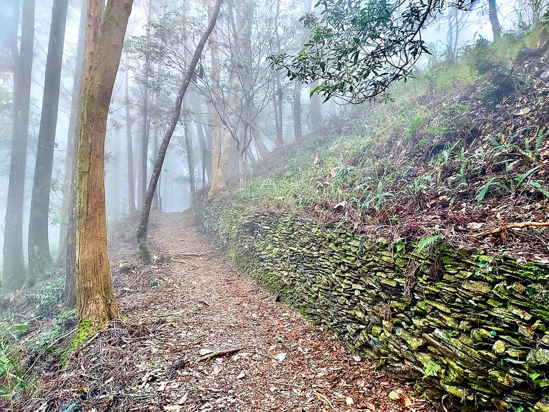
Photo: Tyler Cottenie
Unless you have a four-wheel-drive high-clearance vehicle or a proper motorcycle, you will have to park at some point and walk the last three kilometers to the trailhead, as the last section of road is just loose rock. If you’re walking, enter at the first roadside trailhead (marked with ribbons) and walk up to the ridge. If you can drive to the end, take the second trailhead and walk up to the ridge.
After turning right at the ridge, it’s a gentle climb on a clear path up to Wangzih Mountain (網子山), where you are sure to run into locals lounging around after getting their exercise. Tables and chairs have been set up here, making it an attractive rest spot.
Further north along the trail is where the Japanese-era remains start to appear. Walls of stacked stones nicely frame the meter-wide trail in places. Keep your eyes peeled for the remains of two police stations on the left side of the trail on your way toward Minghai Mountain (鳴海山). The wood in these structures has long disappeared but the stone walls remain intact.
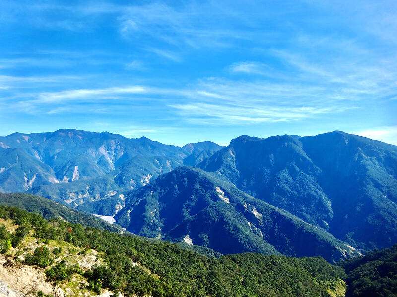
Photo: Tyler Cottenie
EXTENDING YOUR DAY-HIKE
After reaching the high point for the day at Minghai Mountain (1411 m), return the same way to the trailhead fork, then go back down to your vehicle to end the hike or continue south past the trailhead fork to explore more of the Liugui Security Path. The trail gets even flatter and easier, and there are more stone remains of the security trail and police stations, though they are less impressive here.
As you continue southward, you will pass a massive temple whose access road from the other side of the mountain was washed away during a past typhoon. Caretakers still maintain the property via a very rough scooter road coming up from Maolin, but the size of the temple and its remoteness today make for an odd contrast.
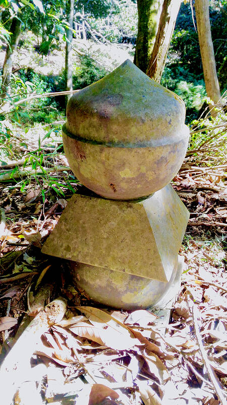
Photo: Tyler Cottenie
Continuing along the ridge, you will pass Zhenwo Mountain (真我山) and its south peak. From here, you can turn around and go back to your car, or cut down the nearby farm road to the village of Maolin below. This route works best with prearranged transportation or if you come with two vehicles and place one at each end beforehand.
If you’re feeling extra adventurous, you can even walk to the very end of the Liugui Security Path by staying along the ridge right down to the Maolin District entrance. This section is more overgrown, but includes another two police stations and great views of the inner valley and outer plains from the narrow ridge.
TRACES OF THE PAST
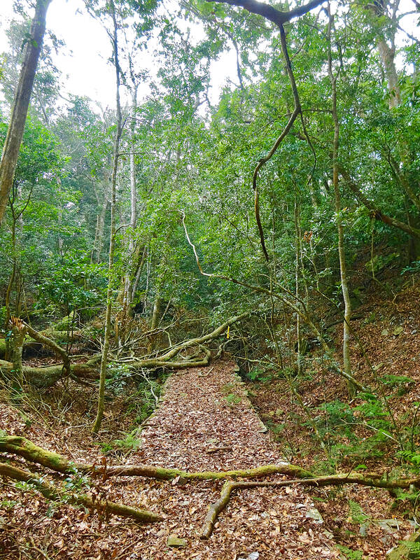
Photo: Tyler Cottenie
If you’re looking to go deeper into the mountains, and into the trail’s past, consider a two-day excursion starting further north near the Tengjhih National Forest Recreation Area (藤枝國家森林遊樂區). To make this work as a two-day trip, you will have to drive yourself or hire transportation and get an early start.
Take the right fork onto the Chuyunshan Forest Road (出雲山林道) just before the Tengjhih visitor center. After 3.3km on this road, at the point where it crosses over into the next river valley, you will see a trailhead. From here, start walking south along the ridge to follow the Liugui Security Path. Highlights of this section include several more police stations, but in a more undisturbed state than the ones near Maolin, with artifacts lying scattered nearby.
When this trail was built, its main purpose was to protect the camphor harvesting work on one side of the trail from interference by the indigenous community on the other side. To this end, 53 small police stations and 4 larger monitoring stations were installed along the way, separated by an average of only one kilometer, which is why so many remains are visible still today.
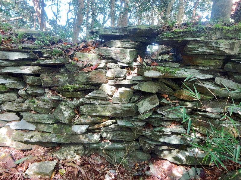
Photo: Tyler Cottenie
To further enhance defenses, an electrified fence was also set up along the entire length of the trail. Though the wooden supports have long rotted away, the ceramic insulators holding up the wires have not degraded and a keen eye will be able to spot these lying on the ground in several places.
Just after Jianfu Mountain (見府山), you will encounter a bizarre sight: a lone sculpted stone pillar sticking up out of the dirt, part of an old Shinto shrine. About two hours further along is a stone-lined pit dug into the mountainside. Life in the police stations up here was cold in the winter, so police officers made their own charcoal for heating in kilns like these. Judging by the number of century-old glass bottles lying around the police stations, drinking Hakutsuru sake was another way the officers kept warm on cold days.
OVERNIGHT ON TRAIL
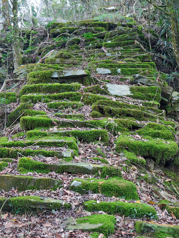
Photo: Tyler Cottenie
After summiting the high point of this section of the trail, Yuyoushan (御油山), the hiking trail leaves the Liugui Security Path and descends to the Fenggangshan Nursery (鳳崗山苗圃). This tree nursery is still in active use by the Forestry Agency so hikers are not really welcome here, especially on weekdays when staff are present. That being said, there may be water flowing from the faucets so some people do camp here on weekends.
Continue uphill on the forest road next to the nursery until you reach the ridge again to rejoin the Liugui Security Path. There is plenty of space beside the road to set up tents here, and there are two streams along the way where hikers can get water before setting up camp.
The next morning, a two or three-hour walk will get you to perhaps the most attractive remains on the trail, those of the Akasaka Station, with tall stone walls still standing and plenty of artifacts lying around.
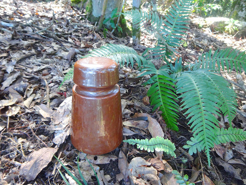
Photo: Tyler Cottenie
The station gets its name from the 36th station along the Tokaido, the ancient coastal route between Kyoto and Tokyo in Japan. That Akasaka is also the 36th police station on the Liugui Security Path is no coincidence: exactly 53 police stations were built on this trail and named in the same order as the 53 stations of the Tokaido in Japan.
The remainder of this section contains several well-preserved sections of stone-reinforced trail. Later, the trail passes a large flat area that held a police station in the past but now houses a weather observation station, before finally making its ascent up to reach Minghai Mountain and the rest of the trail as described above.
The original Liugui Security Path was actually much longer, extending north up to the village center of modern-day Taoyuan District. One small section is well preserved inside the Tengjhih National Forest Recreation Area, but completing the remainder on foot requires an additional three days. Nevertheless, the sections already described here present the best the trail has to offer today and are a great way to spend an afternoon, a day or a weekend in Kaohsiung.

Taiwan’s English education system is being pulled apart by three opposing forces. Bilingual Nation 2030 pulls students toward English and global communication. Artificial Intelligence (AI) readiness pulls them toward digital judgment, verification and AI-mediated work. But Taiwan’s old exam culture pulls them back toward memorization, grammar drills, timed reading and correct answers. If the education system keeps using old exams to define success, it risks producing graduates who are neither genuinely bilingual nor genuinely AI-ready, but trained for tasks machines can already perform. The first force is Bilingual Nation 2030. Launched in 2018, the policy aimed to “help Taiwan’s workforce connect

It seems every few days one bumps into one of those “real man” comments in which Taiwan is urged to “face reality” or similar, and “make a deal,” with the speaker implying that soon it will be too late. “Deal” advocates always present themselves as having a superior grip on reality, and the manly ability to make the “hard choice.” Their testosterone-laden language often echoes that of Taiwan sellout advocates. Note that such commentary always specifies a process (“make a deal, work with, make progress”), never the end state of what occupation by a violent authoritarian colonialist state will entail. In
June 1 to June 7 "If all Taiwanese were as afraid of dying as you, then what would happen?” Physician Shih Chiang-nan (施江南) reportedly said this to his wife Chen Chiao-tung (陳焦桐) after she urged him to stop intervening on behalf of Taiwanese soldiers stranded overseas after serving in the Japanese Army during World War II. Shih had clashed with high-ranking officials over the issue, engaged in several heated arguments with Taiwan governor-general Chen Yi (陳儀) and allegedly shouted at general Ko Yuan-fen (柯遠芬), chief of staff of the Taiwan Garrison Command, over

“Taiwan’s Opposition Leader Comes to US With a Message Straight Out of Beijing” read a May 31 headline in the Wall Street Journal. Top US administration officials and members of Congress almost certainly read the WSJ, and if there was a bullet point takeaway that people in Washington should absorb ahead of Chinese Nationalist Party (KMT) Chair Cheng Li-wun’s (鄭麗文) arrival in DC on June 9, that headline is it. The last few columns have discussed this very topic, and the timing is not coincidental. While those top officials likely do not read the Taipei Times, judging by the number