Last week the Economist (“A short history of Taiwan and China, in maps,” July 10) and Al Jazeera both sent around short explainers of the Taiwan-China issue.
The Al Jazeera explainer, which discussed the Cold War and the rivalry between the US and the People’s Republic of China (PRC), began in the postwar era with US intervention in the Chinese Civil War and the Chinese Nationalist Party’s (KMT) retreat to Taiwan. It was fairly standard, and it works because it appeals to the well-understood convention that Taiwan enters history in 1949 when the KMT retreats to it.
Very different, and far more pernicious, was the biased, error-studded production by the Economist. Centering Taiwan against Chinese history, it claimed that “After Japan’s defeat in 1945 Taiwan was ceded to the nationalist government of the ROC [Republic of China]” and that Taiwan became a province of the Qing empire in 1885. Neither is correct: Taiwan was not made a province by the Manchus until 1887, and it was never ceded to the ROC. Moreover, in the best pro-China fashion, Japanese rule in Taiwan simply disappears from the discussion.

Photo courtesy of the Council of Indigenous Affairs
The slant was most interesting in the maps and descriptions. European colonization in Taiwan was “harsh” but the Qing “at first showed little interest in the island.” Manchu rule is not characterized by the Economist with a pejorative adjective, but I rather think the indigenous people worked to death in Manchu labor programs (during the period of “little interest”), whose rebellions were brutally suppressed, or who lost their land and mobility to Han settler land-grabbing, could think of a few choice words to describe it. In the Economist’s hopelessly pro-PRC presentation, Japan engaged in a “bloody expansion throughout the region,” but the Qing merely “captured” Taiwan and “expanded China’s territory.” I guess they did that all bloodlessly.
The word “Manchu” does not, of course, appear in the text. Those mysterious Qing just materialize momentarily in history to do China the favor of grabbing Taiwan, then swiftly disappear, taking their complicated sovereignty with them into oblivion.
By far the most interesting map in the collection of maps the Economist uses to spin its yarn is the map depicting the Dutch period. The Dutch are shown to control a U-shaped area across the bottom of Taiwan and extending up the east coast north of Changbin (長濱) and far into the east coast Rift Valley. The indigenous “Kingdom of Middag” occupies what is now Changhua and Taichung counties, and the Spanish are granted the whole of the northeast coast down to Suao in Yilan, and the west down to roughly Jhubei City in Hsinchu County. A large, unlabeled gray area dominates the center of the map of Taiwan.
Photo courtesy of the Hsinchu County Government
The Dutch and Spanish maps are mere historical fantasy. The Dutch could hardly move about outside of Tainan without a military escort, and their presence was really little more than a set of dots on a map. They might have represented to the home office that they controlled such and such an area, but they did so only with the acquiescence of the indigenous peoples, who, had they banded together, could easily have tossed them off the island.
ERASING HISTORY
These mapping conventions are an important way that indigenous history, sovereignty and power are simply erased. Note that on the Economist’s map the indigenous interior exists as an unlabeled gray area. Imagine the map for a moment with the territories of the different indigenous peoples marked clearly and at the same level as the Dutch. To do that, though, would establish them as sovereign powers, and expose the deep racism inherent in PRC claims to Taiwan and in the idea that indigenous land is not land that somebody already owns.
Photo: Huang Ming-tang, Taipei Times
The reason such simplified maps pop up so often in pro-China constructions of Taiwan’s history is that they normalize control as claims on a map, denoted by color. The claims themselves become control. For example, we are used to seeing maps titled something like “The Thirteen Colonies of British North America on the Eve of the Revolutionary War,” with neat colors denoting each colony. The reality is that the Revolutionary War was fought largely on indigenous land, a fact lost in those neat colored spaces.
The act of displaying maps of history in a succession that shows, say, the expansion of the US across the continent, or the expansion of colonial control in Africa, or the expansion of colonial control in Formosa, hide simple facts: indigenous resistance kept out invaders for centuries. The succession of maps itself acts as a rhetorical artifact that makes the expansion appear more inevitable than it was. Consider: in the whole of my life I have never seen a map of the colonies in North America in the 17th or 18th century label the Iroquois Confederacy as the greatest power on the continent, even though they were. The dots on the map of northeastern North America that represented European trading posts and forts existed at the sufferance of the Iroquois and other indigenous peoples, who wanted their weapons and goods for use against their real enemies, each other.
LIES
Similarly, maps of the “greatest extent” of Manchu control of Taiwan lie in two ways. First, indigenous resistance to Manchu expansion is almost never given its own area, properly labeled. It is usually depicted on maps as a blank, as if awaiting inevitable absorption, a process, the maps seem to complain, rudely cut short by the Japanese in 1895. Such a map will never open up its viewers to the possibility that absorption was not inevitable. Second, “greatest extent” maps lie about the reality of Manchu control. For most of the 250 years of Manchu “rule” on Taiwan, the majority of the island was indigenous-controlled. A “greatest extent” map thus hides the effectiveness of indigenous resistance.
Superimposed on modern maps of Taiwan, maps showing this or that area of control also hide another key fact of indigenous power: the interior remain unmapped until well into the Japanese era.
The reason that Dutch and Spanish control are readily presented in pro-PRC constructions of Taiwan history is that presentation of their colonial space shapes the subsequent perception of Manchu colonization. Once the viewer accepts that a colored space is saying “here is the area of Dutch control” and “here is the area of Spanish control,” they can then easily accept a map that shows the whole island as a colored space in the Manchu Empire, thus normalizing Manchu (and in turn, PRC) sovereignty across the whole island and making indigenous sovereignty disappear. Moreover, they imply that PRC sovereignty over Taiwan is in some sense a response to European colonization.
In reality, throughout most of history down to the 20th century, the area of “control” was limited to the presence of imperial firepower, and “control” occurred only by permission of the native peoples. The succession of maps of control thus offers an inevitable sequence of colonization in which indigenous control is never formally shown until all the map becomes one color and indigenous power is... erased.
Notes from Central Taiwan is a column written by long-term resident Michael Turton, who provides incisive commentary informed by three decades of living in and writing about his adoptive country. The views expressed here are his own.

Ajay Verma, a consultant gastroenterologist at Kettering general hospital in Northamptonshire, says our gut is a “complex machine.” “It is constantly providing us with the nutrition we need, initially to grow and develop, and then for us to survive, thrive and repair from injury and illness.” How can we keep it functioning well? Put simply: “Make sure what you put into it is balanced, and that you clear out its waste products adequately,” Verma says. “In a general gastroenterology clinic, the most common conditions we see are irritable bowel syndrome (IBS), gastroesophageal reflux disease, inflammatory bowel disease and constipation,” says Nisha
The arithmetic is straightforward and uncomfortable. By the end of 2025, Taiwan had committed itself to a 50-30-20 electricity mix — half natural gas, 30 per cent coal, 20 per cent renewables. The Ministry of Economic Affairs’s (MOEA) own monthly energy reports tell a different story. Natural gas reached 47.8 per cent of generation last year. Coal stood at 35.4 per cent, comfortably above its target ceiling. Renewables came in at 13.1 per cent, well short of the 20 per cent Taipei had pledged a decade earlier. Installed renewable capacity reached roughly half of the 12 gigawatts (GW) the government
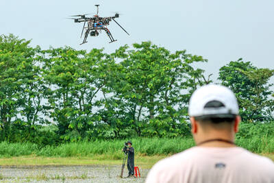
Taiwan’s drone exports are taking off, fuelled by the war in Ukraine, as Taiwanese companies seek a stake in the fast-growing global market for unmanned aerial vehicles (UAV). Low-cost drones used for reconnaissance and strikes are in high demand as governments around the world boost defense spending in the face of intensifying conflicts. A relative new player in the increasingly competitive industry, Taiwan’s pitch is to be an “Asian hub” for the production of UAVs and components free of Chinese materials, or “non-red.” That means its UAVs can be up to three times more expensive than their Chinese competitors, like the world’s biggest
There are shadowy cabals plotting to sell out Taiwan to be annexed by China, by invasion if necessary. Fortunately, they are buffoons. In 2019, former Bamboo Union gangster and founder of the China Unification Promotion Party (CUPP), Chang An-le (張安樂, colorfully known as “White Wolf”), led a protest at the Legislative Yuan against comments made by then-premier Su Tseng-chang (蘇貞昌) that in the event of an attack by China, he would never surrender, but would protect the nation by fighting to the end, even if he only had a broom. Chang had party members bring a wooden casket that they