Even Yu Shi, god of rain, takes a vacation once in a while, removing the gray cloak of clouds that long segregated heaven and earth.
A week’s worth of drizzle is fast evaporating as residents emerge from their homes with the look of creatures awoken from hibernation.
With azure skies overhead, everyone, it seems, will be heading to the hills and coastal parks that arc Taiwan’s capital and its satellites.
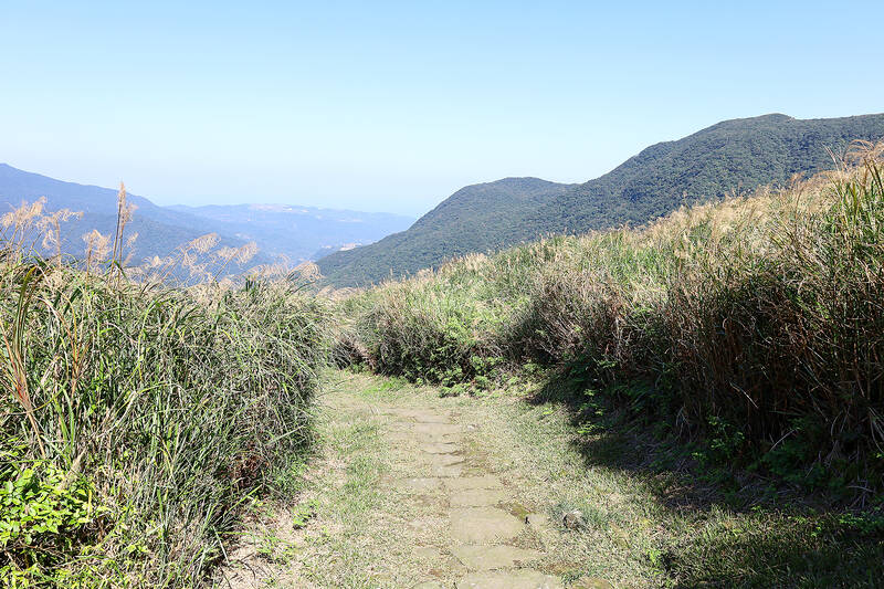
Photo: Thomas Bird, Taipei Times
“It’s going to be busy, no matter where we go,” I say to Tamsui resident Mathias Daccord, noting the succession of cyclists already taking advantage of the fine morning weather.
“Don’t worry, I know a hiking trail that’s quite steep, so it seldom gets crowded,” the Frenchman says.
While still chewing the last mouthfuls of breakfast, we bundle into the car. The drive alone proves worthy of the rush. The road snakes its way out of town, past villages and farmsteads and into the foothills of Yangminshan (陽明山), the forest-coated mountain park that dominates the head of Taiwan. The air is profuse with the scent of lush vegetation.
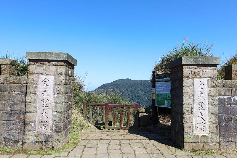
Photo: Thomas Bird, Taipei Times
No sooner does Daccord mention that, “We sometimes see monkeys on this hike,” two Formosan rock macaques, a mother and infant, appear roadside. “You see,” he says, slowing down to salute our new simian friends.
We park near Shanghuang Creek (上磺溪), close to one of the entrance points the Jinbaoli Historic Trail (金包里大路). As Daccord promised, there isn’t many people about, bar a few keen dog walkers.
That said, we’re following a well-beaten path, one that, according to some informative path-side plaques, was first carved out of the forest by “indigenous tribes to travel from their villages and forge marriage alliances.”
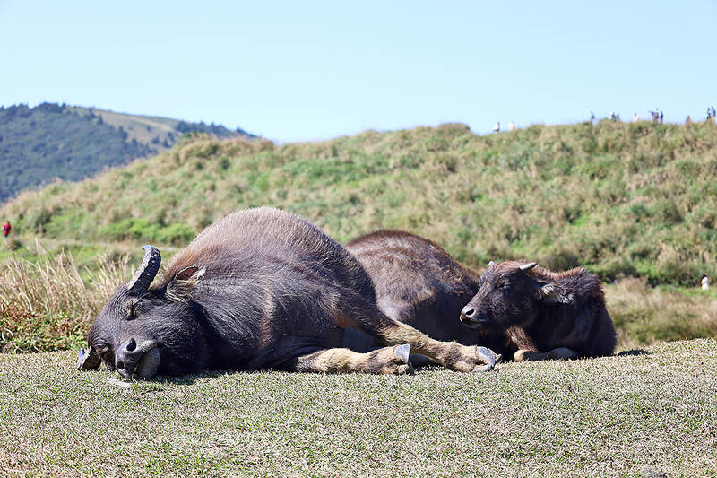
Photo: Thomas Bird, Taipei Times
STRATEGIC PASSAGE
It was Fujianese fishermen migrating across the strait during the Ming and Qing eras that turned these ancient trails into something of a tea road, “a transportation route between Jinshan and Shilin” districts, where goods like “fish, tea and indigo” were carried via buffalo cart or bamboo pack basket.
The strategic passage would later be coopted by Qing soldiers from North China who were sent to pacify rebellions and safeguard the sulfur mines that were essential for gunpower production. After Japan acquired Taiwan in the wake of the Sino–Japanese War of 1895, the colonial administration built “a winding trail” in order to “transport canons,” which is known today simply as the Japanese Road (日人路).
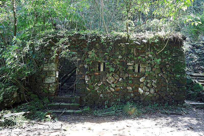
Photo: Thomas Bird, Taipei Times
“The Japanese Road intersects the trail at various points,” explains Daccord as we follow a stone path through a heavily wooded area. “We can follow back down once we reach the top.”
Along the way, streams gush through the woodlands, heavy with a weeks’ worth of rain. Shafts of light bisect the branches. The sound of the water cascading down the hill, combined with birds tweeting from the tree canopy, is pure tonic for those who’ve been immured in urban environs for too long.
There are remnants of the “highway” that was lining the route, moss-covered ruins of buildings and walls from earlier times, including Xuyan Bridge, where we stop to rest. This lovely stone overpass was first built across the creek in 1896 by a wealthy local tea merchant in order to help move his product to buyers on the other side of the range.
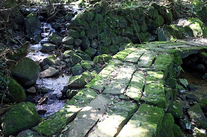
Photo: Thomas Bird, Taipei Times
As we press on, we observe evidence of farms that must have once existed, terraced fields still definable stepping the hillside despite mother nature’s best reclamation efforts.
Eventually we emerge from the shade of the forest cover onto an open path lined by tall grass. The gradient is much steeper once we pass the “Master Stone” –– a giant boulder long used as a boundary marker, and begin to climb the 120 stone steps that lead to the summit.
I periodically stop to catch my breath and enjoy the view, a vista of verdant valleys and sharp ridges stretching towards the deep blue horizon.
‘HILL HOLDING UP HEAVEN’
Reward for our hour-long ascent is to arrive at Qingtiangang (擎天崗), a grassland that goes someway to explain why Yangmingshan had been known as Caoshan (草山) or Grass Mountain before 1950, when former president Chiang Kai-shek (蔣介石) decided to rename the mountain park after a famous Ming Dynasty scholar.
Qingtiangang translates as “Hill Holding Up Heaven,” a poetic, somewhat honey designation no doubt, but one it duly deserves. It’s a spectacle to behold, a flat, saddle-shaped area formed by lava flow from Zhugao Mountain (竹篙山) and encircled by four major peaks. It was the Japanese that turned it into a cattle ranch and tea plantation, although only a heard of water buffalo lazing in the winter sun allude to any kind of agricultural legacy today.
Administrative lines converge on the grassland as it lies in both Taipei’s Shilin District (士林) and New Taipei’s Jinshan District (金山). It is also where a number of trails and roads meet, which probably accounts for the number of weekend walkers we encounter. Still, despite the pedestrian scene of families taking selfies, one still has to pinch ones self when considering that their ambling across a meadow 770 metres above sea level carpeting a lava terrace.
We rest beside the reconstructed Jinbaoli Trail Gate, which, according to legend, was first built by famous anti-Japanese rebel leader Big Lion Jian (Jian Da-shi, 簡大獅). However, as another informative sign reads, “in the end he could not resist the overwhelming Japanese forces…” Jian surrendered in 1898, was enlisted in a road building project but went on to cause more trouble and thus met a premature end in 1900.
With some sense of poetic solemnity, then, we make our way back to the car via the Japanese Road. It is broader, smoother, if slightly longer than the original trail, as it traces the contour lines of the hillside.
Before we reach tree cover again, we’re treated to more incredible views of north Taiwan’s topography. It would be a cloudless scene, were it not for the volcanic vapors rising from fumaroles, the breath of the mountain cast into the air high above New Taipei.

Taiwan’s English education system is being pulled apart by three opposing forces. Bilingual Nation 2030 pulls students toward English and global communication. Artificial Intelligence (AI) readiness pulls them toward digital judgment, verification and AI-mediated work. But Taiwan’s old exam culture pulls them back toward memorization, grammar drills, timed reading and correct answers. If the education system keeps using old exams to define success, it risks producing graduates who are neither genuinely bilingual nor genuinely AI-ready, but trained for tasks machines can already perform. The first force is Bilingual Nation 2030. Launched in 2018, the policy aimed to “help Taiwan’s workforce connect
It seems every few days one bumps into one of those “real man” comments in which Taiwan is urged to “face reality” or similar, and “make a deal,” with the speaker implying that soon it will be too late. “Deal” advocates always present themselves as having a superior grip on reality, and the manly ability to make the “hard choice.” Their testosterone-laden language often echoes that of Taiwan sellout advocates. Note that such commentary always specifies a process (“make a deal, work with, make progress”), never the end state of what occupation by a violent authoritarian colonialist state will entail. In
There are shadowy cabals plotting to sell out Taiwan to be annexed by China, by invasion if necessary. Fortunately, they are buffoons. In 2019, former Bamboo Union gangster and founder of the China Unification Promotion Party (CUPP), Chang An-le (張安樂, colorfully known as “White Wolf”), led a protest at the Legislative Yuan against comments made by then-premier Su Tseng-chang (蘇貞昌) that in the event of an attack by China, he would never surrender, but would protect the nation by fighting to the end, even if he only had a broom. Chang had party members bring a wooden casket that they
June 1 to June 7 "If all Taiwanese were as afraid of dying as you, then what would happen?” Physician Shih Chiang-nan (施江南) reportedly said this to his wife Chen Chiao-tung (陳焦桐) after she urged him to stop intervening on behalf of Taiwanese soldiers stranded overseas after serving in the Japanese Army during World War II. Shih had clashed with high-ranking officials over the issue, engaged in several heated arguments with Taiwan governor-general Chen Yi (陳儀) and allegedly shouted at general Ko Yuan-fen (柯遠芬), chief of staff of the Taiwan Garrison Command, over