Syuhai (旭海) is a small hot spring and fishing village at the end of the road on the Pacific coast of Pingtung County. Just beyond lies a section of wild coastline stretching north to Taitung County, now designated as the Alangyi Historic Trail (阿塱壹古道). Hikers ply this route daily, leaving nothing but footprints, just as people have done here for centuries. Now protected as a nature reserve, this is a wonderful chance to see why this island earned itself the name of Formosa.
Our guided hike began at the trail’s south end in Syuhai. Stepping out onto the rocky beach, we were greeted with a big open sky, the sound of the crashing waves, the rattling of beach rocks being dragged down into the water by the retreating waves, and a long expanse of grey, green and blue ahead of us, unmarred by road, power line or structure. Just a few steps in, it already felt like we had left the civilized world behind.
After passing a checkpoint where our permits for the day were cross-checked against our IDs, we continued on. The area around the trail is now protected as the Xuhai-Guanyinbi Nature Reserve, so all visitors to this trail require a difficult-to-obtain permit (more on that later) and must be accompanied by a guide. This is a fairly recent development in the long history of this trail.
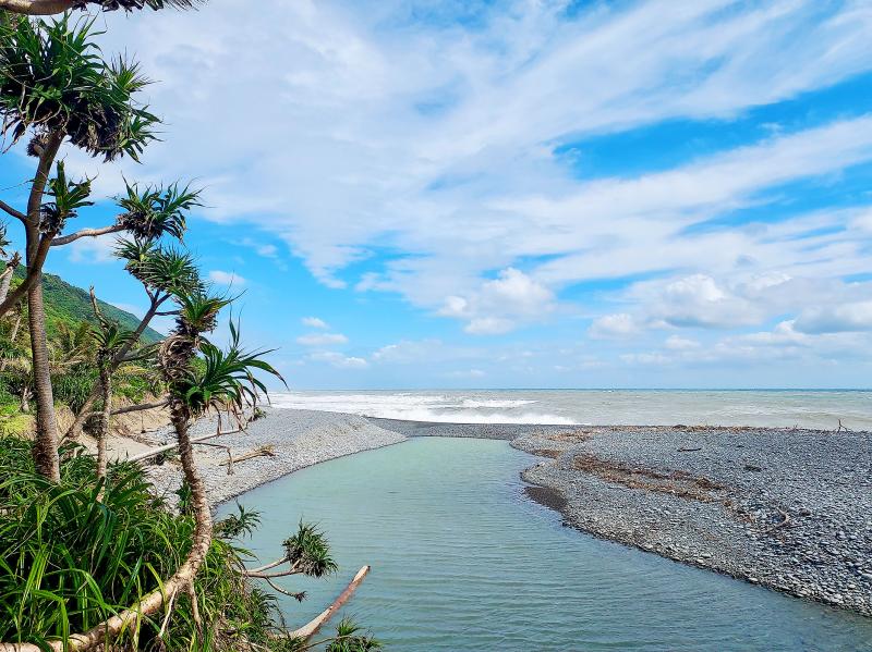
Photo: Tyler Cottenie
LONG HISTORY OF HUMAN USE
Before the reserve was established in 2012, the coastline was uncontrolled and tourists were free to explore it on their own terms. In fact, there has been foot traffic here for centuries. The Alangyi is actually just a small section of a longer historical trail, the Langciao–Beinan Trail (琅嶠–卑南道). Those who have seen the recent Netflix special Seqalu: Formosa 1867 will recognize the name Langciao, which is an older name for the Hengchun area.
The Langciao–Beinan Trail was a route used by outsiders to reach the east coast as early as the Dutch era. Hopeful Dutch gold miners had heard tales of a golden river on the east coast and enlisted the help of Langciao Aboriginals to guide them. This expedition passed along today’s Alangyi Historic Trail on their way up the east coast in a years-long venture that would eventually prove fruitless. But with that, the trail had entered the historical record.
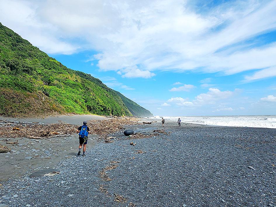
Photo: Tyler Cottenie
The “trail” itself is mostly unimproved coastline with no sign of maintenance or conscious design. We walked mostly on the loose beach rocks, with unobstructed views of miles of coastline, towering green hills on one side and the mighty Pacific on the other. The trail occasionally entered the adjacent screwpine, and one seasonal stream was full of water thanks to recent rains, requiring an easy knee-deep fording. Winter is the ideal time to visit the trail, when even sunny days are tempered by the ocean breeze.
The Alangyi is one of the few sections of unimproved coastline remaining on the island of Taiwan, though it nearly had a different fate. Provincial Highway 26 already winds along the coast of much of the Hengchun Peninsula and was originally meant to continue along the coast to Taitung. The final section in Taitung County is already completed, as is a section south of Syuhai, but there are two gaps remaining in this road.
One of these is the Alangyi Historic Trail, and after much lobbying from environmentalist groups, it was decided in 2012 to establish a nature reserve here and cancel the plan to complete Highway 26. For now, visitors are still able to see this piece of the island much the same as it was centuries ago.
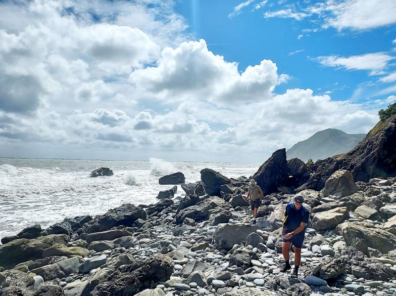
Photo: Tyler Cottenie
The Dutch gold miners originally tried reaching Beinan by ship, but were discouraged by poor weather and the strong Kuroshio Current off Taiwan’s east coast, forcing them to attempt a land crossing. Today, this current brings objects from far away and dumps them on the beaches here. Most of this is, unfortunately, plastic trash and fishing tackle, not exactly in line with the goal of a nature reserve. For tourists, it detracts somewhat from the view, but a game can be made of trying to identify where some of these items originated.
Our guide also pointed out some pumice stones on the beach, which are likely not of local origin. The gases trapped inside the pumice made it buoyant, allowing it to float to Taiwan after formation in a volcanic eruption elsewhere.
CLIMBING OVER THE CAPE
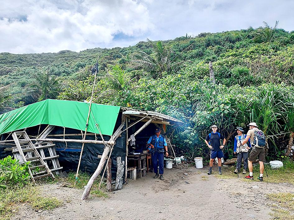
Photo: Tyler Cottenie
The trail eventually approaches a headland known locally as Cape Guanyin (觀音鼻). There is no beach on which to walk to skirt this landform: the rock drops steeply straight into the sea. The trail avoids this obstacle by climbing up the adjacent hill, traversing for a while, and then descending to the beach again on the far side of Cape Guanyin.
This is the only strenuous part of the hike, as the climb is rather steep. However, the views of the ocean from the top are the highlight of the trip for many. The end of the trail and the populated coastline beyond can be seen from here, and on sunny days, the turquoise Pacific waters are a gorgeous sight. This is a great place to stop and rest for a while as you soak in the scenery and fresh air.
After descending to the beach, another 10 minutes of walking brought us to the north checkpoint, where our names were again checked against the official list for the day. The Pingtung County Government is quite serious about controlling traffic on this trail: not only does it have guards stationed at checkpoints on both ends, but the fine for being caught here without a permit (and guide) is between NT$30,000 and NT$150,000.
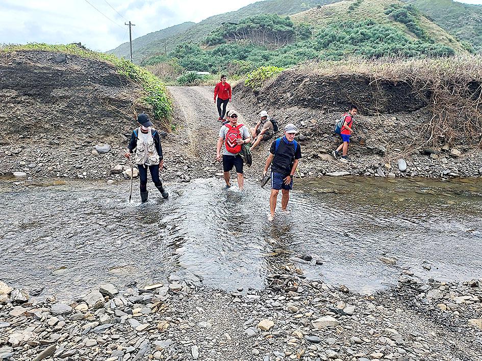
Photo: Tyler Cottenie
After the checkpoint there is a short section of farm road to walk and a small river to ford (marking the Pingtung-Taitung boundary) before arriving at the north parking lot, where Provincial Highway 26 starts up again. This highway continues up to the village of Anshuo (安朔村). The traditional land of the Aboriginal residents here includes the territory of today’s Alangyi Historic Trail. In fact, the modern name for this section of trail comes from this village’s traditional Paiwan name: Aljungic.
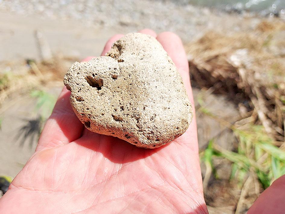
Photo: Tyler Cottenie
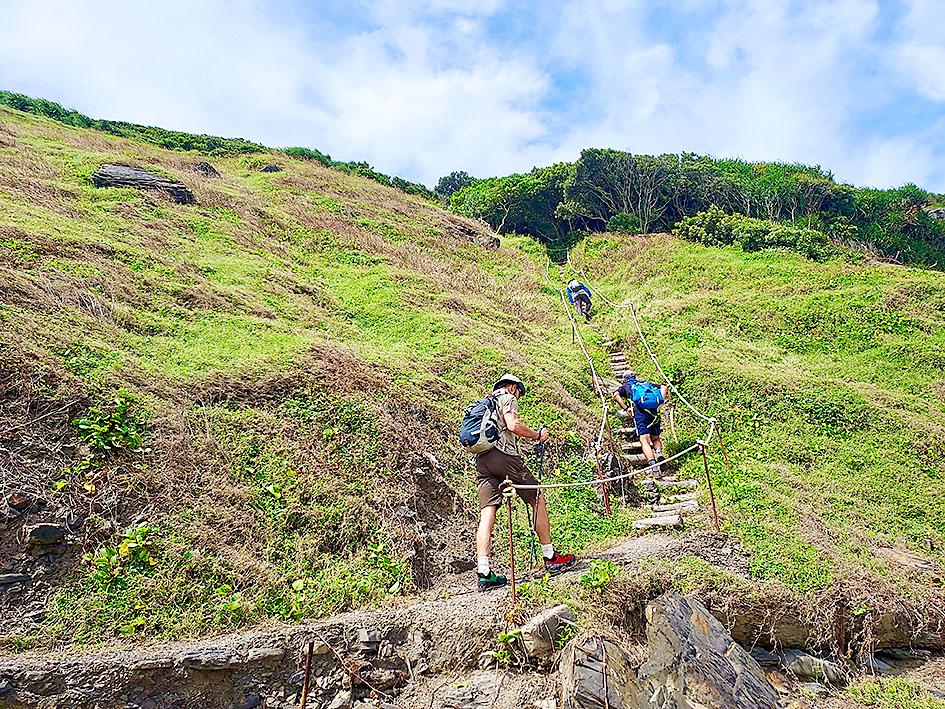
Photo: Tyler Cottenie

For many people, Bilingual Nation 2030 begins and ends in the classroom. Since the policy was launched in 2018, the debate has centered on students, teachers and the pressure placed on schools. Yet the policy was never solely about English education. The government’s official plan also calls for bilingualization in Taiwan’s government services, laws and regulations, and living environment. The goal is to make Taiwan more inclusive and accessible to international enterprises and talent and better prepared for global economic and trade conditions. After eight years, that grand vision is due for a pulse check. RULES THAT CAN BE READ For Harper Chen (陳虹宇), an adviser
Traditionally, indigenous people in Taiwan’s mountains practice swidden cultivation, or “slash and burn” agriculture, a practice common in human history. According to a 2016 research article in the International Journal of Environmental Sustainability, among the Atayal people, this began with a search for suitable forested slopeland. The trees are burnt for fertilizer and the land cleared of stones. The stones and wood are then piled up to make fences, while both dead and standing trees are retained on the plot. The fences are used to grow climbing crops like squash and beans. The plot itself supports farming for three years.

The breakwater stretches out to sea from the sprawling Kaohsiung port in southern Taiwan. Normally, it’s crowded with massive tankers ferrying liquefied natural gas from Qatar to be stored in the bulbous white tanks that dot the shoreline. These are not normal times, though, and not a single shipment from Qatar has docked at the Yongan terminal since early March after the Strait of Hormuz was shuttered. The suspension has provided a realistic preview of a potential Chinese blockade, a move that would throttle an economy anchored by the world’s most advanced and power-hungry semiconductor industry. It is a stark reminder of

May 4 to May 10 It was once said that if you hadn’t performed at the Sapphire Grand Cabaret (藍寶石大歌廳), you couldn’t truly be considered a star. Taking the stage at the legendary Kaohsiung club was more than just a concert. Performers were expected to entertain in every sense, wearing outlandish or revealing costumes and staying quick on their feet as sharp-tongued, over-the-top hosts asked questions and delivered jokes that would be seen as vulgar, even offensive, by today’s standards. Opening in May 1967 during a period of strict political and social control, Sapphire offered a rare outlet for audiences in