As always, it was a happy reunion. A week earlier I’d secreted my bicycle within earshot of Provincial Highway 14, several kilometers west of Nantou’s Puli Township (埔里). After unlocking it and wiping the dust off the saddle, I pedaled slowly over the 118m-long Doushan Suspension Bridge (斗山吊橋), which spans Nangang Creek (南港溪).
Turning east, I followed a country road that meanders in the shadow of Freeway 6, the elevated fast-road to Puli. A few minutes later, upon reaching the main street of Beishan (北山), I thought about a friend who used to live in Taiwan. We took a few day-trips into the hills, and he got into the habit of categorizing any settlement we passed through as “betgabon” or “not betgabon.”
Betgabon was an acronym he’d come up with meaning “big enough to get a bowl of noodles.” Beishan is betgabon, but only just. I was there because it’s at the western end of Nantou Local Road 68 — a route I hoped would be a scenic way to bypass the busy center of Puli.

Photo: Steven Crook
Doushan Suspension Bridge is about 300m above sea level, while Beishan is slightly higher. Nantou Local Road 68 climbs to an elevation of almost 600m, then drops down to 460m, all within 8.98km.
HONORING THE ‘YIMIN’
As I’d expected, the uphill stretch was a proper cardiovascular workout. To catch my breath, I paused whenever I saw something remotely interesting. I decided against trying to get closer to Yumenguan Waterfall (玉門關瀑布) — the track looked steep and slippery. A few hundred meters further on, just past Chung-Ling Elementary School (鍾靈國小), I stopped at Guangfu Temple (廣福宮).

Photo: Steven Crook
The school closed down four years ago, a consequence of rural depopulation and an aging society. But the shrine and the adjacent community center were surprisingly lively for a weekday morning.
Guangfu Temple honors yimin (義民), the spirits of men who died defending Hakka villages during the uprisings that ravaged Taiwan during the Qing Dynasty era. Over time, they became all-purpose deities. When Hakka pioneers, such as the forefathers of those who live in this area, moved into the mountains, they entreated the yimin for protection from natural disasters and aboriginal headhunters.
The huge banyan in front of the temple is more interesting than anything inside the shrine. Buttressed by girders, the tree’s sprawling canopy now covers the courtyard.

Photo: Steven Crook
After puffing my way up another hill, the last thing I expected to see was a wetland. With very few exceptions, Taiwan’s wetlands abut the coast, and I’d never heard of any in the uplands. Yet Caonan Wetland (草湳溼地) exists right beside the highest section of Nantou Local Road 68.
On the day I cycled by, this ecotourism site wasn’t open to the public, so I peered over the gate. It certainly looks like a real wetland. Later, I read that it’s about 3 hectares in area, and home to nearly 200 plant species.
At the end of the exhilarating descent into Taomi (桃米), I braced myself for heavy traffic on the main road to Sun Moon Lake (日月潭). Taomi is known for having recovered from the 921 Earthquake (which flattened two thirds of the village) by reinventing itself as an ecotourism destination.

Photo: Steven Crook
One of Taomi’s sights is the Paper Dome (紙教堂). Even though its Chinese name means “paper church,” this unusual building isn’t now a place of worship. It was made in Japan from laminated and fireproofed layers of recycled paper, and used there as a Catholic church. Some years after it was dismantled, the pieces were donated to Taomi. A local foundation reassembled it, and added an exterior membrane of steel and waterproof polycarbonate to protect this intriguing structure from typhoons.
Compared to the empty and nicely shaded Nantou Local Road 68, Provincial Highway 21 was a sweaty maelstrom of trucks and tour buses. Gritting my teeth, I cycled south, through a 445m-long tunnel, and into the outskirts of Yuchih (魚池).
Yuchih is betgabon and then some. After lunch, I looked for the intersection of Road 131 and Nantou Local Road 67. I’d taken this back route to Sun Moon Lake once before by motorcycle. I remembered it being a delight, and suspected — rightfully, it turned out — that I’d be pushing my bike on the steeper sections.
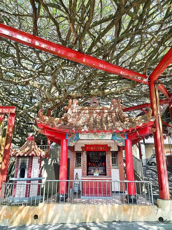
Photo: Steven Crook
Nantou Local Road 67 weaves between betel-nut plantations, orchid farms, and sheds in which mushrooms are grown. The tarmac merges with Nantou Local Road 69, climbs to 820m above sea level, drops down a little, then rises to 810m where it hits Provincial Highway 21A (台21甲).
SUN MOON LAKE

Photo: Steven Crook
By emerging onto the road that encircles Sun Moon Lake at this spot, I was avoiding the crowds at Wenwu Temple (文武廟) and the traffic bound for Shueishe’s (水社) hotels and restaurants.
As I worked my way around the eastern lakeshore — initially on a purpose-built bikeway, then on the main road — I stopped again and again to take in the view. After getting here by leg power, I felt I’d earned my sightseeing. Despite the dull sky, some of the reedbeds around Dajhuhu (大竹湖) and its waterbird refuge had an attractive golden-brown hue.
I saw no reason to stop in the compact lakeside village called Ita Thao (伊達邵), but the appeal of Xuanzang Temple (玄奘寺) is its connection to my childhood. Both it and the nearby Xuanguang Temple (玄光寺) preserve relics associated with Xuanzang (玄奘), a seventh-century Buddhist monk revered for traveling to India so he could bring back and translate religious texts.
When I was an elementary school student, I often watched a Japanese TV show known to Britons of my generation as Monkey. What I didn’t know then was that the show was inspired by the classic Chinese novel Journey to the West, which itself is a fictionalized account of Xuanzang’s epic 17-year journey.
According to one tally, at least 3,000 Chinese Buddhists departed for India between the fourth and seventh centuries. Around 80 of them, it’s believed, reached the subcontinent. Xuanzang was one of just 15 known to have survived the return journey.
Cycling over a few hills to Sun Moon Lake, then down to Changhua’s high-speed station, doesn’t seem much of an accomplishment by comparison, does it?
Steven Crook has been writing about travel, culture and business in Taiwan since 1996. He is the author of Taiwan: The Bradt Travel Guide and co-author of A Culinary History of Taipei: Beyond Pork and Ponlai.

Sept.16 to Sept. 22 The “anti-communist train” with then-president Chiang Kai-shek’s (蔣介石) face plastered on the engine puffed along the “sugar railway” (糖業鐵路) in May 1955, drawing enthusiastic crowds at 103 stops covering nearly 1,200km. An estimated 1.58 million spectators were treated to propaganda films, plays and received free sugar products. By this time, the state-run Taiwan Sugar Corporation (台糖, Taisugar) had managed to connect the previously separate east-west lines established by Japanese-era sugar factories, allowing the anti-communist train to travel easily from Taichung to Pingtung’s Donggang Township (東港). Last Sunday’s feature (Taiwan in Time: The sugar express) covered the inauguration of the

The corruption cases surrounding former Taipei Mayor and Taiwan People’s Party (TPP) head Ko Wen-je (柯文哲) are just one item in the endless cycle of noise and fuss obscuring Taiwan’s deep and urgent structural and social problems. Even the case itself, as James Baron observed in an excellent piece at the Diplomat last week, is only one manifestation of the greater problem of deep-rooted corruption in land development. Last week the government announced a program to permit 25,000 foreign university students, primarily from the Philippines, Indonesia and Malaysia, to work in Taiwan after graduation for 2-4 years. That number is a
This year’s Michelin Gourmand Bib sported 16 new entries in the 126-strong Taiwan directory. The fight for the best braised pork rice and the crispiest scallion pancake painstakingly continued, but what stood out in the lineup this year? Pang Taqueria (胖塔可利亞); Taiwan’s first Michelin-recommended Mexican restaurant. Chef Charles Chen (陳治宇) is a self-confessed Americophile, earning his chef whites at a fine-dining Latin-American fusion restaurant. But what makes this Xinyi (信義) spot stand head and shoulders above Taipei’s existing Mexican offerings? The authenticity. The produce. The care. AUTHENTIC EATS In my time on the island, I have caved too many times to

In a stark demonstration of how award-winning breakthroughs can come from the most unlikely directions, researchers have won an Ig Nobel prize for discovering that mammals can breathe through their anuses. After a series of tests on mice, rats and pigs, Japanese scientists found the animals absorb oxygen delivered through the rectum, work that underpins a clinical trial to see whether the procedure can treat respiratory failure. The team is among 10 recognized in this year’s Ig Nobel awards (see below for more), the irreverent accolades given for achievements that “first make people laugh, and then make them think.” They are not