It was quite the sight: Ten full-grown adults began jumping for joy — whooping, cheering, and hugging each other. The drivers of two nearby vans stood by stunned as two whole pineapples and a case of beer were then shamelessly devoured. Such was the jubilation — and the hunger — experienced by this group of hikers, returning to civilization after a 10-day journey through Taiwan’s high mountains.
A LONG HIKE
In order to complete the most sought-after 100 peaks in Taiwan — the baiyue (百岳) as they are known — some longer treks are required to reach the more remote mountains. The longest of these “sections,” and the subject of this article, is the South Third Section (南三段), clocking in at 10 days for the average hiker.
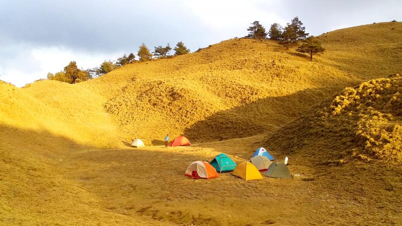
Photo: Tyler Cottenie
One April morning in the Hualien County town of Rueisui (瑞穗), our group of 10 loaded our backpacks into a Mitsubishi Delica, and a piled in together for the ride up to the trailhead.
Fitting 10 days of food into a backpack is no easy feat — my own backpack weighed 26kg, while others were closer to 30kg — and fitting 10 overstuffed backpacks into an already overloaded vehicle required the spatial intelligence of a Tetris master. However, our driver was up to the task, and the Delica — a true workhorse of the mountains — easily hauled all of us up the steep forestry road to the trailhead.
Forestry roads like this one snake their way up many of the nation’s major river valleys. Their upper reaches have been abandoned for decades, and are now a mess of vegetation, landslides and old workers’ huts in various stages of ruin. They are a silent reminder of Taiwan’s logging past, but their lower reaches remain an important way to access many of Taiwan’s high mountains. Our Delica took us up 19 kilometers, but the final 15 kilometers would have to be crossed on foot.
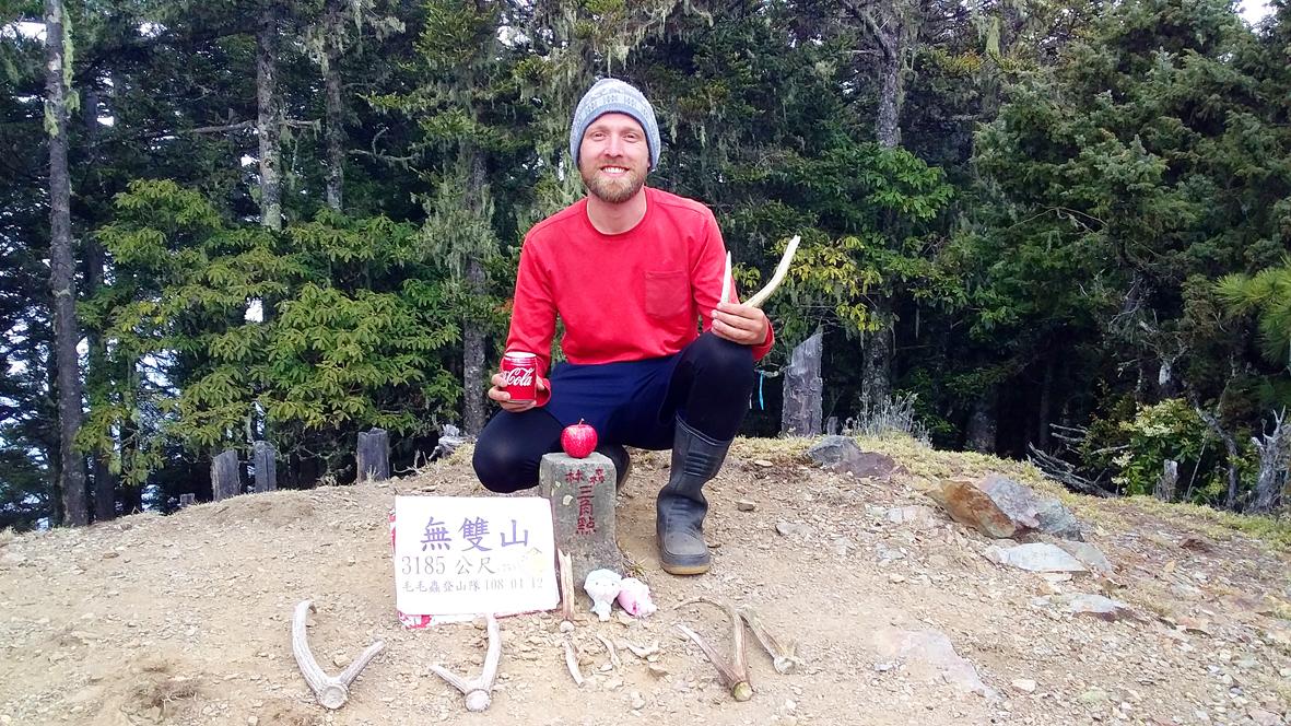
Photo: Tyler Cottenie
FROM HUALIEN TO NANTOU
After a few hours of hiking, it began to drizzle. With my rain boots on and my umbrella, I would stay comfortably dry. Many experienced hikers use rain boots, as they offer protection against wet feet not only while it’s raining, but also when the undergrowth is damp from dew or fog drip.
We soon arrived at one of the abandoned workers’ huts and decided to make camp here for the night. Despite its lack of doors, windows, furniture or electricity, a concrete building like this is a blessing for hikers on a rainy day. We each staked our claim to a small patch of dry, bare concrete, threw down our sleeping pads and hung our food out of reach of hungry little mammals.
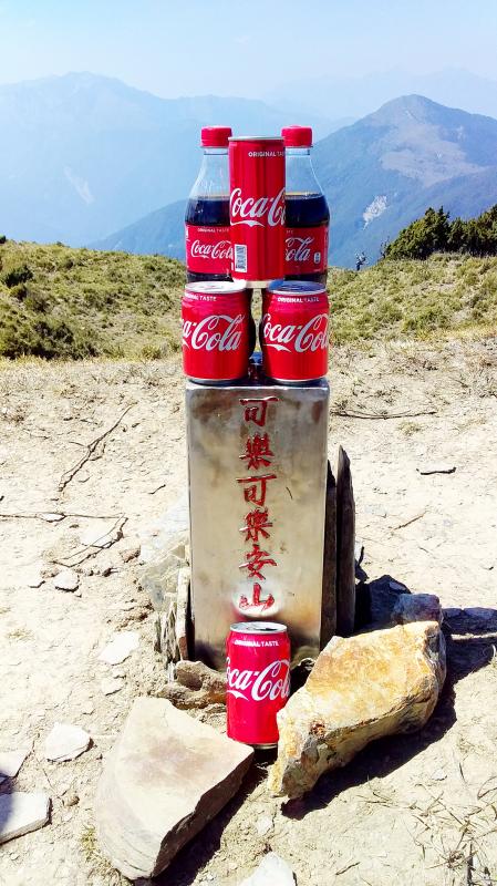
Photo: Tyler Cottenie
A campfire was soon lit and we spent the rest of the afternoon snacking, drinking tea and chatting; at low elevations like this, there is no phone signal, so there is no scrolling through Facebook to pass the time. Getting to camp early and having a lazy afternoon like this is one of the great pleasures of a group hike.
Inside the hut, we also came across several pounds of fresh vegetables. We’d heard that two days before our trip began, another group had been forced to abandon their hike and return to the trailhead due to an injury. We figured these veggies must have been left behind by this group, and we wasted no time in throwing them on the fire and enjoying the extra nutrition.
This surprise feast of water bamboo, onions and peppers was both a blessing, and a reminder to tread carefully in the coming days. Our group was fortunate enough not to have any major injuries, but the trip was not without incident.
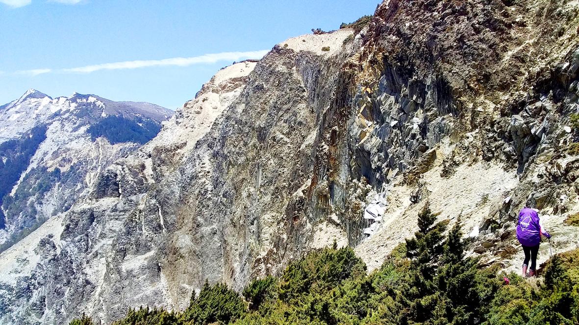
Photo: Tyler Cottenie
One of our members was simply carrying too much weight, and for the next two days, he struggled to make it up every slope, was exhausted to the point of vomiting and slowed our progress significantly. I worried we might have to turn around as there was no way we could keep going for eight more days this way.
Eventually our guide made a decision that might have saved our trip. He asked this hiker to dump out everything in his pack and cut out anything unnecessary. Some excess food was left behind or taken by others in the group. Some people took weight off the porter so this hiker could offload yet more weight. Finally, even his tent was ditched and he was told to share with another hiker. Five or six kilograms lighter, he still struggled throughout the trip but was able to finish, though his body weight did drop from 56kg to 49kg.
The other incident occurred on the eighth morning, when those of us at the front of the group heard a bloodcurdling scream from a hiker at the back. The guide went back to investigate and I overheard something about “falling off.” After several tense minutes, the guide reappeared around the corner and explained to us that the porter’s tall backpack had gotten caught on a tree branch, causing him to fall off the trail and slide down into a ravine. He had rolled down about 30 meters but, thankfully, he slid into bowl-shaped terrain and came to a gentle stop at the bottom, uninjured. If this had happened a hundred meters earlier or later, however, the fall would have been anything but gentle.
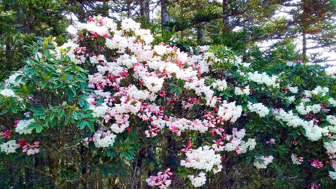
Photo: Tyler Cottenie
Otherwise, our trek along South Third Section went splendidly. The high mountain environment is a world apart from the industrial lowlands of Taiwan. We made our way through bamboo meadows and rocky cliffs under sunny skies, day after day. Hot days gave way to cold nights, when the mercury dropped to as low as five degrees. The rhododendrons were in bloom, dotting the landscape with white and pink. We came across specimens of the sambar deer, both dead and alive, and one of our favorite activities was searching for their antlers. We passed exotically named peaks like Yisichingmajhi (義西請馬至山) and Kelekelean (可樂可樂安山) and camped near the sources of pristine rivers.
TRACES OF FORMER RESIDENTS
After Wushuang Mountain (無雙山), a steep, knee and morale-destroying descent through slippery pine needle forest brought us back down into the civilized world. We camped for a night near the remains of several Aboriginal slate houses, passed through Wushuang Village (無雙社) — a massive cleared area full of slate house remains, pottery and glass bottles, whose Bunun residents were forced to relocate in 1934 — before reaching what some might call the climax of the trip: the Wushuang Suspension Bridge.
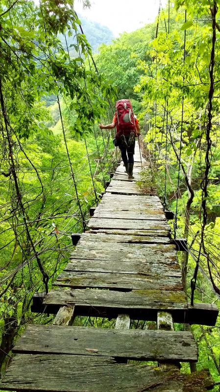
Photo: Tyler Cottenie
Somewhere around 100 years old, it is amazing that this bridge is still passable at all. The boards that haven’t already fallen away are in varying stages of rot. Under normal circumstances, most sane people would likely refuse to walk across it. However, the only other way out of the mountains involves an abandoned police trail, a sketchy descent down to the river several kilometers downstream, and an additional day tacked onto the trip. There was thus no hesitation: we would all cross this bridge.
Once on the other side, we still had to camp one more night on the trail. Finally, on the tenth day, we made it down to our drivers, waiting for us with freshly cut pineapple and cold beer. Mission accomplished.
A recent report from the Environmental Management Administration of the Ministry of Environment highlights a perennial problem: illegal dumping of construction waste. In Taoyuan’s Yangmei District (楊梅) and Hsinchu’s Longtan District (龍潭) criminals leased 10,000 square meters of farmland, saying they were going to engage in horticulture. They then accepted between 40,000 and 50,000 cubic meters of construction waste from sites in northern Taiwan, charging less than the going rate for disposal, and dumped the waste concrete, tile, metal and glass onto the leased land. Taoyuan District prosecutors charged 33 individuals from seven companies with numerous violations of the law. This

As mega K-pop group BTS returns to the stage after a hiatus of more than three years, one major market is conspicuously missing from its 12-month world tour: China. The omission of one of the group’s biggest fan bases comes as no surprise. In fact, just the opposite would have been huge news. China has blocked most South Korean entertainment since 2016 under an unofficial ban that also restricts movies and the country’s popular TV dramas. For some Chinese, that means flying to Seoul to see their favorite groups perform — as many were expected to do for three shows opening

What is the importance within the Chinese Nationalist Party (KMT) of the meeting between Xi Jinping (習近平), the leader Chinese Communist Party (CCP), and Cheng Li-wun (鄭麗文), the leader of the KMT? Local media is an excellent guide to determine how important — or unimportant — a news event is to the public. Taiwan has a vast online media ecosystem, and if a news item is gaining traction among readers, editors shift resources in near real time to boost coverage to meet the demand and drive up traffic. Cheng’s China trip is among the top headlines, but by no means
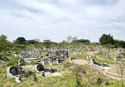
Apr. 13 to Apr. 19 From 17th-century royalty and Presbyterian missionaries to White Terror victims, cultural figures and industrialists, Nanshan Public Cemetery (南山公墓) sprawls across 95 hectares, guarding four centuries of Taiwan’s history. Current estimates show more than 60,000 graves, the earliest dating to 1642. Besides individual tombs, there are also hundreds of family plots, one of which is said to contain around 1,000 remains. As the cemetery occupies valuable land in the heart of Tainan, the government in 2018 began asking families to relocate the graves to make way for development. That