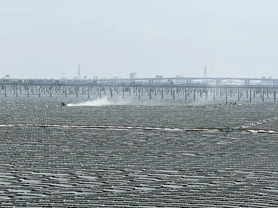
Taiwan has some spectacular coastal scenery and plenty of amazing waterfalls, but it’s unusual to enjoy both on the same trip. The Suhua Highway (蘇花公路), however, has both, and just a two-hour drive from Taipei. Despite the hassles of traveling along it, the highway between Yilan County’s Suao Township (蘇澳) and Hualien has perhaps the most spectacular coastal scenery in Taiwan, and when friends come to visit, I almost always tack on a drive along it either before or after the compulsory trip to Taroko Gorge. ah
The 118km-long Suhua Highway originated as one of three routes created to gain access to the interior and east coast of the island. The other two are the original Batongguan Old Trail (八通關古道) in Nantou and Hualien counties and the Jinshueiying Ancient Trail (浸水營古道).
The three routes were established after 54 shipwrecked Japanese sailors from the Ryuku Islands were killed by Aborigines in 1871 near the southern tip of the island. The Japanese used the incident to launch a brief invasion of Taiwan later the same year and, finding the feat unexpectedly easy, fomented plans for a second invasion attempt 14 years later, which was successful.
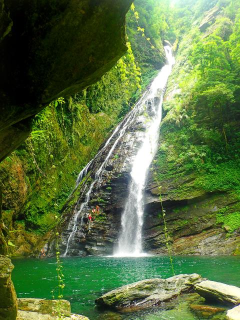
Photo: Richard Saunders
In the 1920s, the Japanese started building a gravel road (following a different, parallel route from the Qing-era path), and it was that which eventually became today’s Suhua Highway.
For decades after it opened to cars, the road was a one-lane affair, and vehicles had to take it in turns, traveling along sections and queuing at designated places to wait while traffic in the opposite direction was allowed through. I can attest that as late as the 1990s, several long tunnels were still one-lane affairs, and drivers faced an interminably long wait if they missed a green traffic light.
Things have improved greatly in the two decades since, and the current Suhua Highway Improvement Project (started in 2011 and slowly opening in sections) is seeing much more of the highway being burrowed into the cliffs, away from the hazards of falling rocks and landslides, as eight new tunnels are finished.
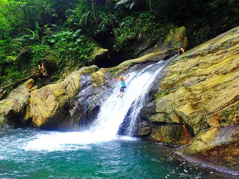
Photo: Richard Saunders
The first tunnels are already open, between Suao and Nanao (南澳) townships, and the old road between the towns (which can still be followed) is a delight to motor along nowadays, as there’s relatively little traffic.
Although wider and safer than a couple of decades ago, the Suhua Highway remains probably the riskiest of Taiwan’s major highways. It is fairly narrow in many places, often with a sheer drop into the ocean, and, to make matters worse, heavy lorries and other big vehicles continue to zoom along it at often unreasonable speeds, so driving it can be a nerve-wracking experience (now the summer holidays are underway, I wouldn’t dream of attempting it on the weekend). If you get good weather, though, it’s one of the nation’s most exhilarating drives.
WATERFALLS
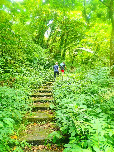
Photo: Richard Saunders
There are at least five waterfalls either just off or close to the highway, and although two of them, including the wonderful upper Jinyue Waterfall (金岳瀑布), can only be reached by a river trace, the others are easy enough to visit.
The lower fall at Jinyue (which doubles as possibly Taiwan’s highest and scariest natural waterslide) is just a couple of minutes from the road turning off the Suhua Highway at Nanao in the direction of Jinyue (金岳). Follow the road up beside the stream, and leave your vehicle in the car park at the end. Walk down to the stream, and paddle up to the base of the waterfall, just a minute or two upstream.
From here, it’s an hour or so up to the main fall, a dramatic white spout plunging 30 meters into a huge pool. It’s a short river trace, and not too difficult, but don’t attempt it without experience and all the proper river tracing gear. It’ll be heaving with river tracers at weekends this time of year.
South of Nanao, the cliff scenery continues, broken only briefly as the road descends several times to villages nestled along the alluvial plains at the mouths of rivers that cut their way through the central mountains and empty into the Pacific.
The twin townships of Yilan County’s Aohua (澳花) and neighboring Heping (和平) lie on one of these wide river mouths, but the beauty of area is ruined by a hideous power station and cement factory.
So before reaching Heping (surely the low point of any trip along the Suhua Highway) turn right into the little aboriginal village of Aohua for a short but memorable detour to perhaps the finest waterfall on the east coast.
Aohua is an Atayal community and the authorities here, as in so many places, have prettified it by adding colorful, tourist-pleasing murals of happy Aborigines and their wares. A kilometer or so off the highway, pass through Aohua Village, keeping to the road past the sports field, and soon afterwards, a large boulder inscribed with red-painted characters points the way towards Aohua Waterfall, up the big valley ahead.
The road follows the wide stream up, and although it’s now unsurfaced, its condition is good, and two-wheel drive cars will have no problem unless it’s very wet. If you’re riding a scooter, carry on all the way to the bridge over the stream, otherwise park the car beside the road in another kilometer or so (there’s enough room for six or seven cars), and walk the final 15 minutes to the little bridge, just before the stream forks into two branches, each cascading down from the high mountains in front.
Follow the track beside the right-hand branch of the stream, and it soon becomes a concrete-stepped path. Climb over a gentle rise and then down the other side to the huge, deep plunge pool at the foot of spectacular Aohua Waterfall (澳花瀑布). This 50 meter-high plunge is a very impressive sight. Even more tempting at this time of year, it falls into a huge, cold plunge pool perfect for swimming.
Richard Saunders is a classical pianist and writer who has lived in Taiwan since 1993. He’s the founder of a local hiking group, Taipei Hikers, and is the author of six books about Taiwan, including Taiwan 101 and Taipei Escapes. Visit his Web site at www.taiwanoffthebeatentrack.com
Ajay Verma, a consultant gastroenterologist at Kettering general hospital in Northamptonshire, says our gut is a “complex machine.” “It is constantly providing us with the nutrition we need, initially to grow and develop, and then for us to survive, thrive and repair from injury and illness.” How can we keep it functioning well? Put simply: “Make sure what you put into it is balanced, and that you clear out its waste products adequately,” Verma says. “In a general gastroenterology clinic, the most common conditions we see are irritable bowel syndrome (IBS), gastroesophageal reflux disease, inflammatory bowel disease and constipation,” says Nisha
The arithmetic is straightforward and uncomfortable. By the end of 2025, Taiwan had committed itself to a 50-30-20 electricity mix — half natural gas, 30 per cent coal, 20 per cent renewables. The Ministry of Economic Affairs’s (MOEA) own monthly energy reports tell a different story. Natural gas reached 47.8 per cent of generation last year. Coal stood at 35.4 per cent, comfortably above its target ceiling. Renewables came in at 13.1 per cent, well short of the 20 per cent Taipei had pledged a decade earlier. Installed renewable capacity reached roughly half of the 12 gigawatts (GW) the government

Last week US President Donald Trump was asked by a reporter whether he would speak on the phone to the President of Taiwan. “l’ll speak to him. I speak to everybody. We have that situation very well in hand,” Trump said. This marked the second time in a couple of weeks he had said he would talk to the President of Taiwan. In 2016 he famously took a call from then-president Tsai Ing-wen (蔡英文), when he was president-elect. Despite warnings that the apocalypse was nigh because of a phone call, the world quickly forgot about the conversation between two democratically-elected presidents.
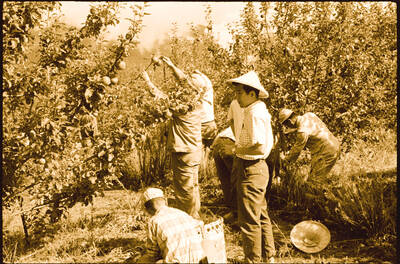
May 25 to May 31 Few believed that apples could be cultivated on a commercial scale in Taiwan’s high mountains. When horticulturalist Cheng Chao-hsiung (程兆熊) first proposed the idea in 1955, both American and Taiwanese colleagues dismissed it as implausible, arguing that temperate fruit could not be reliably grown on a subtropical island, especially on rugged terrain. However, it was this terrain in the Central Mountain Range where many Chinese Civil War veterans were resettled in the late 1950s. With limited job prospects and no family in Taiwan, they were placed on cooperative farms aimed toward self-sufficiency. Some say the conditions