Keen Taipei-dwelling hikers are spoilt for choice when it comes to challenging hikes that provide good adrenaline rushes. The two popular favorites are Huangdidian (皇帝殿), and its larger, slightly tougher brother Wuliaojian (五寮尖), but there are also many other white-knuckle routes in the area. Daredevil walkers living in Taichung have a more limited choice — the pancake-flat plains of Changhua County to the south and one of Taiwan’s dullest stretches of coastline to the immediate west don’t help — but there are a few choice hikes to the east of the city, especially around the Dakeng Scenic Area (大坑風景區), with its unique raised trails made from countless tree branches.
To reach the area’s best hiking, however, it’s necessary to travel a little further east, to the western foothills of the Snow Mountain Range. The lower foothills of Taiwan’s second highest mountain offer s get ome excellent shorter hikes. The best-known are the Guguan Seven Heroes (谷關七雄), two of which I described in an earlier column. The other outstanding hike in the area is Mount Yuanzui (鳶嘴山; Kite’s Beak Peak).
This sharp, rocky flourish has justly become one of Taiwan’s classic day hikes. Mt. Yuanzui (2,130 meters) marks the western extremity of a long ridge that quickly rises to the 3,000-meter level, culminating in the summit of Snow Mountain (雪山) itself, about 30 kilometers northeast.
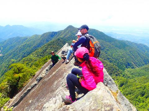
Photo: Richard Saunders
Mt. Yuanzui, with its sensational knife-edge summit, can be combined with nearby Mount Shaolai (稍來山; 2,307 meters) to make a very fine day hike of about six hours. It’s probably the premier challenge day hike in the Taichung area, and a strenuous climb, with a lot of clambering up precipitous rock faces perched over dizzying drops, so fitness and a good head for heights are a prerequisite for attempting it.
Getting out there is a bit of a headache, since the peak lies in a remote area in the east of Taichung City, with no regular public bus service. Fortunately, this is one of the sunniest parts of Taiwan year-round, so once you make it out there, there’s a good chance the weather will cooperate, at least until lunchtime, when afternoon mists may start drifting in.
The trailhead is on the Dasyueshan Forest Road (大雪山林道), which forks off Highway 8 at the town of Dongshih (東勢), east of Taichung’s metropolis. Follow the signs for Dasyueshan Forest Recreation Area (大雪山森林遊樂區).
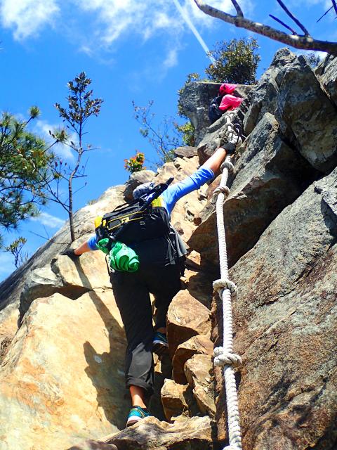
Photo: Richard Saunders
Incidentally this forest road is famed as one of Taiwan’s best bird-watching areas (around 100 species have been recorded here); watch out for bird watchers with huge-lensed cameras beside the road as you drive up. Allow nearly an hour for the drive from Dongshih to the trailhead, which is just after a tunnel, right beside the 27km marker; there’s roadside parking.
It’s a strenuous climb right from the very start, up a precipitously steep wooded hillside with lots of rocky pitches and fixed ropes. It takes 40 to 50 minutes to hike just over a kilometer from the trailhead to the prominent “danger” sign beside the trail at the start of the climb up the summit rock of Mt. Yuanzui itself.
Now the route, with fixed ropes all the way, keeps below the top of the knife-edge blade of rock, using a series of natural cracks supplemented by the occasional iron staple as a foothold to scale the peak. It’s a steep haul in places, but the ascent is relatively straightforward. At the summit the 360-degree view is truly magnificent in clear weather. More adventurous hikers scramble onto the true summit nearby — the highest point of the bare knife-edge spine, although that requires a very good head for heights and great care, as a slip could be fatal.
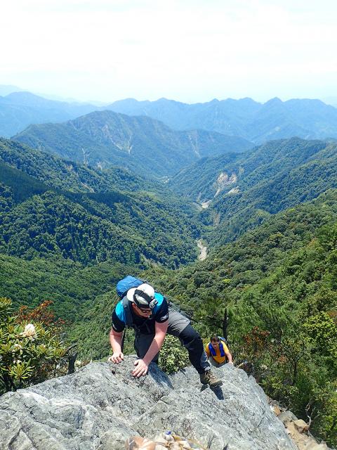
Photo: Richard Saunders
Some walkers turn back at this point and retrace the outward route, because the next section is the most demanding part of the hike, with three very steep pitches down long, exposed rock faces. Immediately after the summit, the trail plunges over the first of these, with fixed ropes and a long line of iron staples hammered into the smooth cliff face to provide footholds.
Finally, a second “danger” sign announces the end of the trickiest section of the hike. A little further a signposted junction marks the point where a decision must be made. The most exciting part of the hike is already over, and to complete a short, sharp hike of about three hours, take the roped-up trail on the right, descending steeply to rejoin the road about 500 meters from the tunnel mouth. The alternative trail keeps to the ridge, following it further eastwards to Mt. Shaolai. Immediately there’s a steep but easy rocky bluff to climb, then the undulating ridgeline trail continues all the way to Mt. Shaolai, with a few fine views en route to break the monotony of the forest.
The summit of Mt. Shaolai is covered in thick forest, but it has an excellent view, courtesy of a tall fire tower which hikers can ascend to enjoy the magnificent wrap-around view from the top, including the conspicuous stone summit peak of Mt. Yuanzui along the ridge to the west. The red abacus-like contraption at the base of the tower is used to confirm how many people are up there at one time. Move one of the ten beads to the right as you go up, and push it back to the left when you come down. For safety reasons a maximum of 10 people are allowed up there at one time.
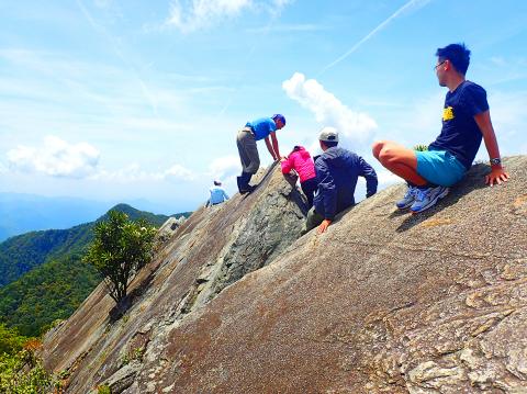
Photo: Richard Saunders
Richard Saunders is a classical pianist and writer who has lived in Taiwan since 1993. He’s the founder of a local hiking group, Taipei Hikers, and is the author of six books about Taiwan, including Taiwan 101 and Taipei Escapes. Visit his Web site at www.taiwanoffthebeatentrack.com.
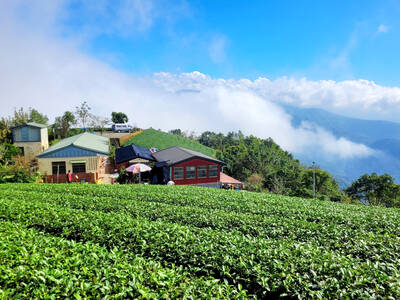
Every now and then, it’s nice to just point somewhere on a map and head out with no plan. In Taiwan, where convenience reigns, food options are plentiful and people are generally friendly and helpful, this type of trip is that much easier to pull off. One day last November, a spur-of-the-moment day hike in the hills of Chiayi County turned into a surprisingly memorable experience that impressed on me once again how fortunate we all are to call this island home. The scenery I walked through that day — a mix of forest and farms reaching up into the clouds

With one week left until election day, the drama is high in the race for the Chinese Nationalist Party (KMT) chair. The race is still potentially wide open between the three frontrunners. The most accurate poll is done by Apollo Survey & Research Co (艾普羅民調公司), which was conducted a week and a half ago with two-thirds of the respondents party members, who are the only ones eligible to vote. For details on the candidates, check the Oct. 4 edition of this column, “A look at the KMT chair candidates” on page 12. The popular frontrunner was 56-year-old Cheng Li-wun (鄭麗文)

“How China Threatens to Force Taiwan Into a Total Blackout” screamed a Wall Street Journal (WSJ) headline last week, yet another of the endless clickbait examples of the energy threat via blockade that doesn’t exist. Since the headline is recycled, I will recycle the rebuttal: once industrial power demand collapses (there’s a blockade so trade is gone, remember?) “a handful of shops and factories could run for months on coal and renewables, as Ko Yun-ling (柯昀伶) and Chao Chia-wei (趙家緯) pointed out in a piece at Taiwan Insight earlier this year.” Sadly, the existence of these facts will not stop the

Oct. 13 to Oct. 19 When ordered to resign from her teaching position in June 1928 due to her husband’s anti-colonial activities, Lin Shih-hao (林氏好) refused to back down. The next day, she still showed up at Tainan Second Preschool, where she was warned that she would be fired if she didn’t comply. Lin continued to ignore the orders and was eventually let go without severance — even losing her pay for that month. Rather than despairing, she found a non-government job and even joined her husband Lu Ping-ting’s (盧丙丁) non-violent resistance and labor rights movements. When the government’s 1931 crackdown