The nation’s first domestically developed satellite, Formosat-5, has taken images at the resolution it was designed to deliver, but only “when weather conditions are good,” Ministry of Science and Technology (MOST) officials said yesterday, adding it has completed its mission of capturing satellite images of Taiwan.
The satellite was launched from Vandenberg Air Force Base in California on Aug. 25 last year, but the first images it transmitted back in September last year were fuzzy and marred by light spots.
Since then, the National Space Organization (NSPO) has been working to improve its image quality using image processing software and by adjusting the satellite’s altitude, angle and the temperature of its imaging device.
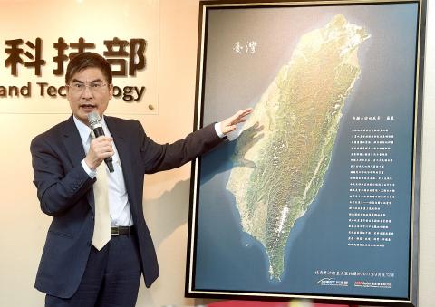
Photo: Chien Jung-fong, Taipei Times
At a news conference in Taipei yesterday, project director Chang Ho-pen (張和本) said the satellite has achieved the resolution it was designed to produce — 2m for black-and-white images and 4m for color images — when the weather permits.
“For example, the satellite images taken from above China and from above California can be very different when the former has serious air pollution,” Chang said.
Yet, the NSPO has not quantified what weather conditions would allow the satellite to transmit images at its default resolution, he added.
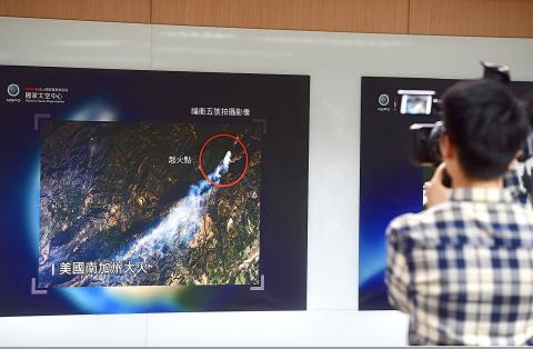
Photo: Chien Jung-fong, Taipei Times
The satellite’s images have already proven sufficient in supporting the nation’s disaster prevention missions, and would be available on the organization’s Web site from September, he said, adding that the US, Japan, Russia and Australia have expressed an interest in purchasing the images.
Asked if Formosat-5’s performance has achieved the ministry’s objectives, Chang said “yes,” while Minister of Science and Technology Chen Liang-gee (陳良基) gave a more reserved response.
The imaging capabilities of Formosate-5 have surpassed those of Formosat-2, which has a 2m resolution for monochromatic images and 8m for colored ones, Chen said.
However, when compared with the US Army’s stricter requirements, it only achieves a 3m resolution for black-and-white images and 5m for colored ones, he said.
As the NSPO is planning to launch one satellite per year in the following 10 years, it will pay more attention to the mechanical adjustment and microwave sensing capabilities of satellites, Chen said.
Meanwhile, Formosat-5, which passes over the same spot on Earth every two days, has finished taking remote images of Taiwan during its orbits between September and December last year, he said.
The ministry presented a complete satellite image of Taiwan to President Tsai Ing-wen (蔡英文) yesterday, with Tsai promising to support its space programs, Chen added.
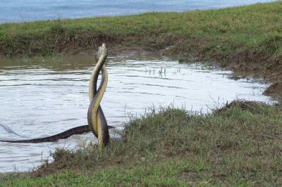
Kenting National Park service technician Yang Jien-fon (楊政峰) won a silver award in World Grand Prix Photography Awards Spring Season for his photograph of two male rat snakes intertwined in combat. Yang’s colleagues at Kenting National Park said he is a master of nature photography who has been held back by his job in civil service. The awards accept entries in all four seasons across six categories: architectural and urban photography, black-and-white and fine art photography, commercial and fashion photography, documentary and people photography, nature and experimental photography, and mobile photography. Awards are ranked according to scores and divided into platinum, gold and
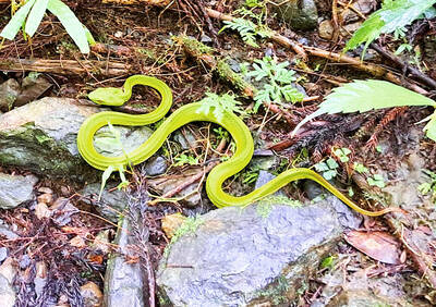
More than half of the bamboo vipers captured in Tainan in the past few years were found in the city’s Sinhua District (新化), while other districts had smaller catches or none at all. Every year, Tainan captures about 6,000 snakes which have made their way into people’s homes. Of the six major venomous snakes in Taiwan, the cobra, the many-banded krait, the brown-spotted pit viper and the bamboo viper are the most frequently captured. The high concentration of bamboo vipers captured in Sinhua District is puzzling. Tainan Agriculture Bureau Forestry and Nature Conservation Division head Chu Chien-ming (朱健明) earlier this week said that the

The Chinese Nationalist Party (KMT) caucus yesterday said it opposes the introduction of migrant workers from India until a mechanism is in place to prevent workers from absconding. Minister of Labor Hung Sun-han (洪申翰) on Thursday told the Legislative Yuan that the first group of migrant workers from India could be introduced as early as this year, as part of a government program. The caucus’ opposition to the policy is based on the assessment that “the risk is too high,” KMT caucus secretary-general Lin Pei-hsiang (林沛祥) said. Taiwan has a serious and long-standing problem of migrant workers absconding from their contracts, indicating that

SPACE VETERAN: Kjell N. Lindgren, who helps lead NASA’s human spaceflight missions, has been on two expeditions on the ISS and has spent 311 days in space Taiwan-born US astronaut Kjell N. Lindgren is to visit Taiwan to promote technological partnerships through one of the programs organized by the US for its 250th national anniversary. Lindgren would be in Taiwan from Tuesday to Saturday next week as part of the US Bureau of Educational and Cultural Affairs’ US Speaker Program, organized to celebrate the 250th anniversary of the signing of the Declaration of Independence, the American Institute in Taiwan (AIT) said in a statement yesterday. Lindgren plans to engage with key leaders across the nation “to advance cutting-edge technological partnerships and inspire the next generation of scientists and engineers,”