The National Applied Research Laboratories (NARL) yesterday unveiled its recently completed Taiwan Ocean Radar Observing System, which researchers said is capable of intensive monitoring of sea conditions, greatly bolstering the nation’s capacity to analyze marine data, conduct rescue missions and contain pollution.
The system comprises 17 radar installations deployed along the nation’s shore and is set to obtain more accurate information on surface currents, such as the Kuroshio current, as well as the tidal movement of the ocean.
Beyond its main mission, the system is expected to greatly assist with rescue efforts and containing ocean pollution, as it can be used to locate fuel leaks or objects adrift at sea, NARL Taiwan Ocean Research Institute research associate and project leader Lai Chien-wu (賴堅戊) said.
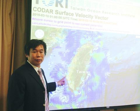
Photo: CNA
Taking advantage of the Doppler effect — the change in frequency of waves from a moving object — the radar installations emit electromagnetic waves in a similar fashion to those shot from a radar speed gun used by police, Lai said.
After hitting an object, the waves bounce back — a phenomenon known as backscatter — enabling analysis of the object’s speed and location at sea, he said.
In the past, maritime rescue missions were carried out based on estimates of locations, determined after analyzing marine data produced over a span of 10 to 20 years. In contrast, the new system produces new data each hour and is capable of conducting analyses across an extensive area, he said.
Citing an incident last year in which a student was carried off by an ocean current after drowning in waters off Kenting’s (墾丁) Nanwan area (南灣), Lai said his team helped the Coast Guard Administration locate the body while testing one of the radar installations near the Ma-anshan Nuclear Power Plant in Pingtung County.
“The student drowned in the afternoon and was still missing by nightfall. Early the next morning, just one hour before the Coast Guard Administration set out to sea to continue searching, they asked for our help,” Lai said.
“Even though we did not know the exact location of the incident, we were able to infer the student’s location by analyzing the tides affected by the southwesterly air streams blowing in the area. We located the body within four hours,” he said.
He said that provided with coordinates indicating the location of an accident, the system can reduce the margin of error during rescue missions down to 1km or 2km, while operations conducted farther out at sea could be contained within a 10km radius for 12 hours — a major improvement to the nation’s preparedness during maritime rescue missions.
He said the NARL and the administration would collaborate on maritime rescue missions using the radar system in the near future.
The NARL put the finishing touches on the system when it deployed the last radar installation at New Taipei City’s Magang Fishing Pier (馬崗) in January, he said.

LOUD AND PROUD Taiwan might have taken a drubbing against Australia and Japan, but you might not know it from the enthusiasm and numbers of the fans Taiwan might not be expected to win the World Baseball Classic (WBC) but their fans are making their presence felt in Tokyo, with tens of thousands decked out in the team’s blue, blowing horns and singing songs. Taiwanese fans have packed out the Tokyo Dome for all three of their games so far and even threatened to drown out home team supporters when their team played Japan on Friday. They blew trumpets, chanted for their favorite players and had their own cheerleading squad who dance on a stage during the game. The team struggled to match that exuberance on the field, with
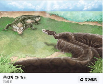
Taiwanese paleontologists have discovered fossil evidence that pythons up to 4m long inhabited Taiwan during the Pleistocene epoch, reporting their findings in the international scientific journal Historical Biology. National Taiwan University (NTU) Institute of Ecology and Evolutionary Biology associate professor Tsai Cheng-hsiu (蔡政修) led the team that discovered the largest snake fossil ever found in Taiwan. The single trunk vertebra was discovered in Tainan at the Chiting Formation, dated to between 400,000 and 800,000 years ago in the Middle Pleistocene, the paper said. The area also produced Taiwan’s first avian fossil, as well as crocodile, mammoth, saber-toothed cat and rhinoceros fossils, it said. Discoveries

Taiwanese paleontologists have discovered fossil evidence that pythons up to 4m long inhabited Taiwan during the Pleistocene epoch, reporting their findings in the international scientific journal Historical Biology. National Taiwan University (NTU) Institute of Ecology and Evolutionary Biology associate professor Tsai Cheng-hsiu (蔡政修) led the team that discovered the largest snake fossil ever found in Taiwan. A single trunk vertebra was discovered in Tainan at the Chiting Formation, dated to between 800,000 to 400,000 years ago in the Middle Pleistocene, the paper said. The area also produced Taiwan’s first avian fossil, as well as crocodile, mammoth, sabre-toothed cat and rhinoceros fossils, it said. Discoveries

Whether Japan would help defend Taiwan in case of a cross-strait conflict would depend on the US and the extent to which Japan would be allowed to act under the US-Japan Security Treaty, former Japanese minister of defense Satoshi Morimoto said. As China has not given up on the idea of invading Taiwan by force, to what extent Japan could support US military action would hinge on Washington’s intention and its negotiation with Tokyo, Morimoto said in an interview with the Liberty Times (sister paper of the Taipei Times) yesterday. There has to be sufficient mutual recognition of how Japan could provide