Former vice president Annette Lu (呂秀蓮) yesterday urged President Ma Ying-jeou (馬英九) to hold an open dialogue with people petitioning for an anti-nuclear referendum to explain the government’s policy on nuclear energy.
“If more than 100,000 people signed the petition, Ma would be obligated to publicly explain his policy,” Lu, who had initiated an anti-nuclear referendum in New Taipei City (新北市), told a press conference.
Lu said her office has collected 32,769 signatures, considerably more than the minimum of 16,000 required to submit a referendum proposal, and would keep working on the second phase, which requires 160,000 signatures in six months for a referendum to be held.
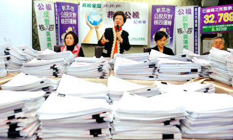
Photo: Chang Chia-ming, Taipei Times
The former vice president also defended a controversial initiative to combine the referendum with the local elections next year, saying that as the referendum is expected to be held in August next year, the timing would be only three to four months away from the local elections and it makes sense to combine the two to save money.
Lu said she did not rule out organizing a rally on May 20 on Ketagalan Boulevard and demanding an open dialogue with Ma on the nuclear issue.
DPP Legislator Cheng Li-chiun (鄭麗君) said that if the Chinese Nationalist Party (KMT) ignored the opinion of residents of Taipei, New Taipei City and Keelung — 63 percent of whom support stopping the construction of the Fourth Nuclear Power Plant in Gongliao (貢寮), according to a recent survey — KMT lawmakers representing these constituencies should be recalled.
.

Fast food chain McDonald's is to raise prices by up to NT$5 on some products at its restaurants across Taiwan, starting on Wednesday next week, the company announced today. The prices of all extra value meals and sharing boxes are to increase by NT$5, while breakfast combos and creamy corn soup would go up by NT$3, the company said in a statement. The price of the main items of those meals, if ordered individually, would remain the same. Meanwhile, the price of a medium-sized lemon iced tea and hot cappuccino would rise by NT$3, extra dipping sauces for chicken nuggets would go up
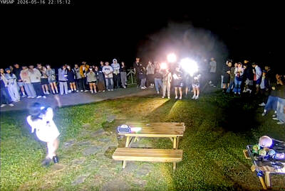
Yangmingshan National Park’s Qingtiangang (擎天崗) nature area has gone viral after a park livestream camera observed a couple in the throes of intimate congress, which was broadcast live on YouTube, drawing large late-night crowds and sparking a backlash over noise, bright lights and disruption to wildlife habitat. The area’s livestream footage appeared to show a couple engaging in sexual activity on a picnic table in the park on Friday last week, with the uncensored footage streamed publicly online. The footage quickly spread across social media, prompting a tide of visitors to travel to the site to “check in” and recreate the

Minister of Digital Affairs Lin Yi-ching (林宜敬) yesterday cited regulatory issues and national security concerns as an expert said that Taiwan is among the few Asian regions without Starlink. Lin made the remarks on Facebook after funP Innovation Group chief executive officer Nathan Chiu (邱繼弘) on Friday said Taiwan and four other countries in Asia — China, North Korea, Afghanistan and Syria — have no access to Starlink. Starlink has become available in 166 countries worldwide, including Ukraine, Malaysia, the Philippines and Vietnam, in the six years since it became commercial, he said. While China and North Korea block Starlink, Syria is not
GROUNDED: A KMT lawmaker proposed eliminating drone development programs and freezing funding for counterdrone systems, despite China’s adoption of the technology China has deployed attack drones at air bases near the Taiwan Strait in a strategy aimed at overwhelming Taiwan’s air defense systems through saturation attacks, the Mainland Affairs Council (MAC) said. The council’s latest quarterly report on China said that satellite imagery and open-source intelligence indicate that the Chinese People’s Liberation Army (PLA) had converted retired J-6 fighter jets into J-6W drones, which the PLA has stationed at six air bases near Taiwan, five in China’s Fujian Province and one in Guangdong Province. The report cited J. Michael Dahm, a senior fellow at the US-based Mitchell Institute, as saying that China has