China intends to launch eight maritime surveillance satellites over the next eight years, a senior official from the National Satellite Ocean Application Service has announced, amid efforts by China to improve its surveillance capabilities in the contested waters of the East and South China Sea.
Jiang Xingwei (蔣興偉), director of the service, said four of the satellites would be used to monitor sea coloration and two to keep track of sea currents which would bring China up to speed with other developed countries on oceanographic surveillance.
Of special interest to other countries involved in territorial disputes with China over islets and waters in the area, including Taiwan and Japan, the other two orbiters are to act as maritime radar satellites to reinforce China’s jurisdiction over those areas.
China currently relies on aircraft and three orbiters to conduct surveillance of its territorial waters and islands — including the Diaoyutai Islands (釣魚台) and Scarborough Shoal (黃岩島, Huangyan Island) — but those do no have the ability to lock on fixed locations, Jiang said, adding that the two new maritime radar satellites would remedy that shortcoming.
Two Hai Yang-1 (HY-1) and one HY-2 oceanography satellites were launched in 2002, 2007 and last year respectively. However, their sun-synchronous orbit means that the satellites are to pass over the same location every two to three days.
Jiang said the additions would also bolster China’s remote-sensing capabilities over waters near other contested islands, including the Paracels (Xisha Islands, 西沙群島) and Spratlys (Nansha Islands, 南沙群島) in the South China Sea by augmenting overall surveillance.
The National Development and Reform Commission has already approved the program, Xinhua news agency reported Jiang as saying yesterday. It is not known whether the new satellites are to be from the HY family or from a different type. According to NASA, China plans to launch HY-2B, HY-2C and HY-2D this year, in 2015 and in 2019.
According to an official from the State Oceanic Administration, since its launch three years ago, the China Oceanic Information Network has expanded its coverage from offshore waters to distant areas and now covers about 300,000km2 of ocean.
Satellite imagery and data are used by the China Marine Surveillance to monitor the “legitimate” and “illegal” use of China’s territorial waters and areas within its exclusive economic zone, as well as to provide maritime services with key information on oil spills and emergencies.

FUKUOKA SITUATION: Japanese media reported that the pathogen is expected to be identified by the summer, while the CDC downplayed the idea that it was hMPV A “mysterious cold-like illness” reported in Japan’s Fukuoka Prefecture does not seem to be a new disease, but Japanese authorities have been asked about the situation, the Centers for Disease Control (CDC) said yesterday. The Fukuoka Prefectural Medical Association on Wednesday told a news conference that a “mystery cold” that has become a hot topic on social media is “highly likely to be caused by some kind of viral infection,” Japan’s KBC News reported. “Many people are experiencing symptoms starting with a sore throat, followed by a runny nose, phlegm and a severe cough,” KBC News reported, citing association officials. Health authorities are

Nvidia Corp CEO Jensen Huang (黃仁勳) arrived in Taiwan yesterday ahead of upcoming AI and technology events, saying he plans to meet with clients and Taiwan Semiconductor Manufacturing Co Chairman C.C. Wei (魏哲家) during his visit. After landing at Taipei Songshan Airport, Huang posed for photos with fans and handed out Yakult drinks to reporters and supporters waiting at the scene, saying he has “a lot to do” during the trip. Asked about reports that Nvidia’s planned headquarters site in Taipei’s Beitou Shilin Technology Park could break ground on May 27, Huang said that if the company holds an event, he would
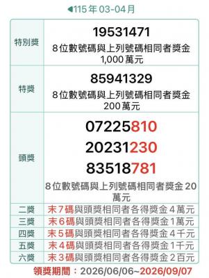
The Ministry of Finance this afternoon announced the winning numbers for the March-April uniform invoice lottery. The winning number for the NT$10 million (US$318,060) special prize is 19531471, and the winning number for the NT$2 million grand prize is 85941329. Three numbers were drawn for the NT$200,000 first prize: 07225810, 20231230 and 83518781. Those with receipts matching the last seven digits of any of the first-prize numbers will win the NT$40,000 second prize, while those matching the last six digits will win the NT$10,000 third prize. Those whose receipts match the last five digits of the first-prize numbers can claim the NT$4,000 fourth prize,

Former president Ma Ying-jeou (馬英九) yesterday expressed “shock and regret” over a statement issued by his wife without his consent, and rejected her assertion that his eldest sister, Ma Yi-nan (馬以南), would manage his medical care or act as his spokesperson amid an ongoing embezzlement probe into his foundation. Ma Ying-jeou in a statement said he was shocked by a statement by his wife, Chou Mei-ching (周美青), regarding his affairs. Ma Yi-nan “must not” be in charge of his healthcare and other personal affairs, nor can she be allowed to represent the Ma family, the former president said. He said he was also