

Research by Taiwanese scientists on gigantic jets of lighting linking thunderclouds and the ionosphere was published yesterday in this week's edition of Nature magazine.
According to Lee Lou-chuang (李羅權), director of the council's National Space Program Office, the letter to Nature detailed the first conclusive observation data in the world indicating that a direct optical path was established from the thunderclouds about 15km above the Earth's surface to the ionosphere at the height of about 90km.

PHOTO: SEAN CHAO, TAIPEI TIMES
Lee, one of co-authors of the letter, stressed that the conventional picture of the global electric circuit needs to be modified to include the contributions of these gigantic jets and possibly sprites.
On July 22 last year, a team led by two physicists at National Cheng Kung University, Su Han-tzong (蘇漢宗) and Hsu Ruey-rong (許瑞榮), took high-resolution images of a rare "giant blue jet," which feeds energy from thunderstorms up into the ionosphere.
Researchers stationed on the southern tip of Taiwan and the university campus observed five giant blue jets, which extended from a thundercloud above the South China Sea near Luzon Island, The Philippines, to the electrically conducting ionosphere.
"A fully-developed gigantic jet optically spanned the thundercloud top at 15 km and the ionosphere at 90 km elevation," Lee said.
The upper bodies of the gigantic jets, which lasted for just 800 milliseconds, was similar to sprites, but their lower bodies resembled blue jets, Lee said.
Lee said that there was no evidence suggesting that the event was triggered by cloud-to-ground lightning. However, Lee said, extremely-low-frequency (ELF) radio waves associated with four of the five gigantic jets were detected by Japanese scientists working at stations in Antarctica and Japan.
In the last 10 years, scientists have discovered that the atmosphere above thunderclouds is not as tranquil as many people imagined.
Anecdotes told by pilots about transient luminous event have been captured by high-tech equipment since 1994. Those events have been classified into three categories: lighting-induced red sprites, upwardly discharging blue jets and gigantic jets.
The discovery of a "giant blue jet" by Victor Pasko of Pennsylvania State University in September 2001 was reported in a Nature cover story in April last year.
In 2001, a National Cheng Kung University team's images of red sprites were chosen as cover photo of Vol. 29 of Geophysical Research Letters,which was published in April last year.
"The potential of Taiwanese scientists deserved to be greatly encouraged," National Science Council Vice Chairman Hsieh Ching-chih (
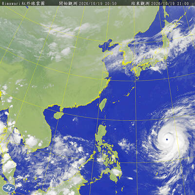
Typhoon Champi is forecast to turn northward earlier than previously expected, sparing Taiwan a direct hit but still bringing heavy rain to the north of the country on Friday and Saturday, the Central Weather Administration (CWA) said yesterday. Typhoon Champi had strengthened and increased in size over the past 12 hours, and as of yesterday afternoon, was packing sustained winds of 198kph near its center, CWA forecaster Cheng Chieh-jen (鄭傑仁) said. However, due to the weakening of a Pacific high-pressure system the storm is now expected to turn northward earlier than initially forecast, likely around Japan’s Ishigaki Island, Cheng said. As Champi brushes

A Chinese People's Liberation Army (PLA) Navy aircraft carrier group was being monitored after entering the western Pacific, the Ministry of National Defense said today, after Beijing yesterday criticized Taiwan for using a water cannon against a Chinese fishing boat near the Pratas Islands (Dongsha Islands, 東沙群島). A Chinese naval task group led by the aircraft carrier Liaoning (遼寧) yesterday sailed to the western Pacific for training, Chinese state-run Xinhua news agency quoted the PLA Navy as saying. “The drill is part of the annual routine training plan aimed at testing and improving the troops’ combat readiness and enhancing their ability to
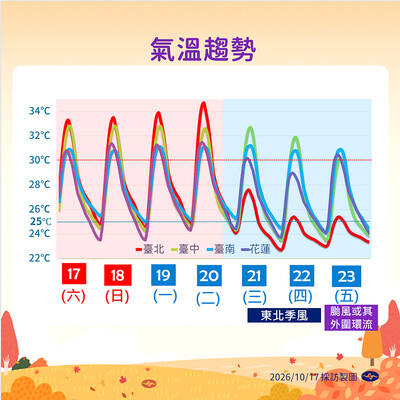
TYPHOON WATCH Champi closes to east Typhoon Champi could continue to strengthen and approach waters off eastern Taiwan by Thursday, with some forecast models suggesting it could move west and cross the nation, the Central Weather Administration (CWA) said yesterday. As of 2pm yesterday, Champi was 2,980km east-southeast of Oluanpi (鵝鑾鼻), Taiwan’s southernmost tip, and moving west at 22kph. It had maximum sustained winds of 162kph and a storm radius of 180km, CWA data showed. CWA forecaster Chang Cheng-chuan (張承傳) said Champi could intensify as it moves west before turning west-northwest toward Taiwan. The storm is expected to reach waters off eastern
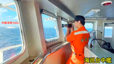
Taiwan said yesterday it had driven away 16 Chinese coast guard, research and fishing vessels involved in simultaneous “maritime harassment” operations. An “unusually large” number of Chinese vessels took part in the coordinated operations around Taiwan proper and Taiwan-controlled Pratas Islands (Dongsha Islands, 東沙群島), the Taiwanese coast guard said in a statement. The Chinese vessels, including four fishing boats, carried out “simultaneous operations at multiple locations and engaged in hybrid warfare,” the statement said. The locations were off Taiwan’s eastern, southern and southwestern coastlines, and around Pratas. Some of the Chinese vessels entered Taiwan’s restricted


 RSS