One of the most powerful typhoons in history is believed to have killed hundreds of people in the Philippines, with a UN disaster official yesterday comparing the destruction caused by towering waves and savage winds to the 2004 Indian Ocean tsunami.
Thousands of soldiers and relief workers were battling to reach communities flattened Super Typhoon Haiyan, with some of the worst-hit areas yet to be contacted yesterday night.
The storm ripped into the eastern islands of Leyte and Samar on Friday morning with sustained winds of about 315kph, generating storm surges that saw 3m-high waves swamp coastal towns.
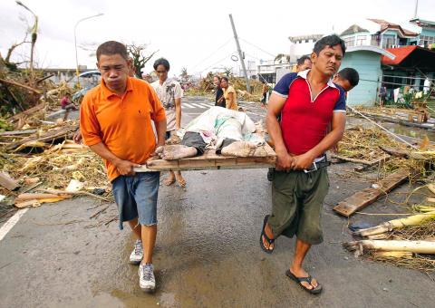
Photo: Reuters
“This is destruction on a massive scale. There are cars thrown like tumbleweed and the streets are strewn with debris,” said Sebastian Rhodes Stampa, the head of a UN disaster assessment coordination team.
“The last time I saw something of this scale was in the aftermath of the Indian Ocean tsunami,” he said, referring to the 2004 disaster that claimed about 220,000 lives.
Stampa made his comments after arriving in Tacloban, the destroyed capital of Leyte, which has a population of about 220,000 people.
More than 4 million people were affected across 36 provinces as Haiyan ripped across the Southeast Asian archipelago, the Philippine government said.
One area of concern yet to be reached was Guiuan, a fishing town of about 40,000 people on Samar that was the first to be hit after Haiyan swept in from the Pacific Ocean.
Philippines Red Cross chief Gwendolyn Pang also said relief workers were trying to get to Capiz province, about 200km west of Tacloban, on Panay Island.
She said most of Capiz’s infrastructure had been destroyed and many houses “flattened to the ground.”
Fifteen thousand soldiers were in the disaster zones to help with rescue efforts, military spokesman Lieutenant-Colonel Ramon Zagala said.
Zagala said helicopters were flying rescuers into priority areas, while infantry units deployed across the affected areas were also proceeding on foot or in military trucks.
Yesterday evening, Pope Francis tweeted his support for the typhoon victims, writing: “I ask all of you to join me in prayer for the victims of Typhoon Haiyan / Yolanda especially those in the beloved islands of the Philippines.”
Haiyan’s wind strength, which remained close to 300kph throughout Friday, made it the strongest typhoon in the world this year and one of the most intense ever recorded.
It exited into the South China Sea yesterday and tracked toward Vietnam, where more than 200,000 people crammed into storm shelters and soldiers helped reinforce vulnerable homes as authorities swung a mass evacuation plan into place. The storm was expected to make landfall in Vietnam early today.
The Red Cross has said Haiyan is likely to be a Category two or three typhoon and warned that about 6.5 million people in Vietnam could be affected.
Philippine authorities had expressed confidence on Friday that only a few people had been killed, citing two days of intense preparation efforts led by Philippine President Benigno Aquino III.
Nearly 800,000 people in danger zones had been moved to evacuation centers, while thousands of boats across the archipelago were ordered to remain secured at ports. Hundreds of flights were also canceled.
Aquino said yesterday night it appeared some communities had not heeded the warnings.
“I hesitate to say this, but it seems that Tacloban was not that prepared, shall we say, compared with other areas,” he told reporters in Manila.
South Korea has adjusted its electronic arrival card system to no longer list Taiwan as a part of China, a move that the Ministry of Foreign Affairs said would help facilitate exchanges between the two sides. South Korea previously listed “Taiwan” as “Taiwan (China)” in the drop-down menus of its online arrival card system, where people had to fill out where they came from and their next destination. The ministry had requested South Korea make a revision and said it would change South Korea’s name on Taiwan’s online immigration system from “Republic of Korea” to “Korea (South),” should the issue not be

Tainan, Taipei and New Taipei City recorded the highest fines nationwide for illegal accommodations in the first quarter of this year, with fines issued in the three cities each exceeding NT$7 million (US$220,639), Tourism Administration data showed. Among them, Taipei had the highest number of illegal short-term rental units, with 410. There were 3,280 legally registered hotels nationwide in the first quarter, down by 14 properties, or 0.43 percent, from a year earlier, likely indicating operators exiting the market, the agency said. However, the number of unregistered properties rose to 1,174, including 314 illegal hotels and 860 illegal short-term rental
ECONOMIC COERCION: Such actions are often inconsistently applied, sometimes resumed, and sometimes just halted, the Presidential Office spokeswoman said The government backs healthy and orderly cross-strait exchanges, but such arrangements should not be made with political conditions attached and never be used as leverage for political maneuvering or partisan agendas, Presidential Office spokeswoman Karen Kuo (郭雅慧) said yesterday. Kuo made the remarks after China earlier in the day announced 10 new “incentive measures” for Taiwan, following a landmark meeting between Chinese President Xi Jinping (習近平) and Chinese Nationalist Party (KMT) Chairwoman Cheng Li-wun (鄭麗文) in Beijing on Friday. The measures, unveiled by China’s Xinhua news agency, include plans to resume individual travel by residents of Shanghai and China’s Fujian

Chinese President Xi Jinping (習近平) and Chinese Nationalist Party (KMT) Chairwoman Cheng Li-wun (鄭麗文) met in Beijing yesterday, where they vowed to bring people on both sides of the Taiwan Strait closer to facilitate the “great rejuvenation of the Chinese nation.” The meeting was held in the East Hall of the Great Hall of the People, a venue typically reserved for meetings between Xi and foreign heads of state. In public remarks prior to a closed-door meeting, Xi, in his role as head of the Chinese Communist Party (CCP), said that Taiwan is historically part of China, and remains an “inalienable” and