US semiconductor giant Intel and Finnish mobile phone maker Nokia announced on Tuesday that they had entered into a “strategic relationship” to develop futuristic mobile computing devices.
Intel, the world’s biggest computer-chip maker, and Nokia, the largest mobile phone manufacturer, said their partnership would seek to “define a new mobile platform beyond today’s smartphones, notebooks and netbooks.”
The alliance between the leaders in their respective fields would enable “the development of a variety of innovative hardware, software and mobile Internet services,” they said in a statement.
Intel dominates the chip market for computers but has had little success in its attempts to break into the mobile phone arena.
The Santa Clara, California-based Intel and Helsinki-based Nokia did not unveil plans for any specific products but said they would collaborate in developing operating systems for the future mobile computing devices using open-source Linux software.
“With the convergence of the Internet and mobility as the team’s only barrier, I can only imagine the innovation that will come out of our unique relationship with Nokia,” said Anand Chandrasekher, a senior vice president at Intel. “The possibilities are endless.”
“Today’s announcement represents a significant commitment to work together on the future of mobile computing, and we plan to turn our joint research into action,” said Kai Oistamo, an executive vice president at Nokia.
“We will explore new ideas in designs, materials and displays that will go far beyond devices and services on the market today,” Oistamo said.
Intel’s tie-up with Nokia comes slightly more than two weeks after the semiconductor maker announced that it has agreed to buy software company Wind River Systems for US$884 million in a bid get its chips into more devices.
Intel said that its takeover of Wind River is part of its strategy to grow beyond its traditional personal computer and server markets and into mobile handheld devices and other systems.

‘NO SECURITY RISK’: The Railway Bureau reassured the public that the technicians’ activities were limited to technical guidance and did not involve sensitive systems The Railway Bureau yesterday said it had invited eight Chinese technicians to assist with an airport MRT construction project. The bureau issued the confirmation after an Internet user said Chinese nationals had entered the construction zone of Taiwan Taoyuan International Airport’s Terminal 3 project. They asked why “individuals from an enemy state” were allowed access to such a major national infrastructure project, which raised serious concerns over Taiwan’s industrial safety, sensitive systems and information security. The bureau’s Northern Region Engineering Branch Office said subcontractor Taiwan Handle Industrial Co (台灣手把工業) of the Taoyuan airport MRT’s “Contract No. CU05 Project A14 Station Civil, MEP &
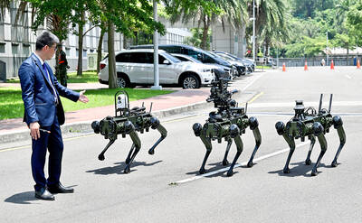
The National Chungshan Institute of Science and Technology yesterday showcased its locally developed variants of the Vision 60 robotic patrol dog, which it plans to deploy on the nation’s outlying territories in the South China Sea. The variants were produced under the Joint Lab project — created by the institute and domestic companies — and assembled with domestically produced motors, lenses and artificial intelligence (AI) systems alongside licensed tech from the US, Missile and Rocket Systems Research Division deputy director Jen Kuo-kang (任國光) told the media event at a military base in Taipei’s Dazhi (大直) area. Taiwan has built up its strengths
NOT IMMEDIATE: Taiwan has a chance to appeal the proposed 10 percent tariff before it starts, while other countries face a 12.5 percent tariff from the trade office Taiwan is among 60 economies determined by the US to have failed to impose or enforce a ban on the importation of goods produced with forced labor, according to a notice released on Tuesday by the Office of the US Trade Representative (USTR), which proposed imposing an additional 10 percent or more tariff on them. The USTR in a statement said that following an investigation, it had determined under Section 301 of the Trade Act of 1974 that the failure of the 60 economies to impose and effectively enforce a prohibition on the importation of goods produced with forced labor is
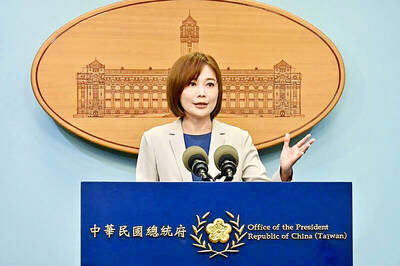
TIT-FOR-TAT: The US allegedly revoked the visa of a Chinese national working at Xinhua News Agency in the US in response to Beijing’s expulsion of Vivian Wang The Presidential Office yesterday condemned China for expelling a New York Times correspondent from Beijing following the newspaper’s interview with President William Lai (賴清德), saying the move highlighted Beijing’s suppression of press freedom and its threat to international news media. Taiwan has noted a series of recent incidents in which Beijing used similar tactics to “threaten and pressure international media outlets and journalists,” Presidential Office spokeswoman Karen Kuo (郭雅慧) said in a statement. “This concerns not only press freedom and freedom of expression, but also the safety of journalists, and Taiwan and relevant partners are paying close attention to the situation,” she