The world’s first cargo ship partly propelled by solar power took to the seas yesterday in Japan, aiming to cut fuel costs and carbon emissions when automakers ship off their exports.
Auriga Leader, a freighter developed by shipping line Nippon Yusen KK and oil distributor Nippon Oil Corp, took off from a shipyard in the western city of Kobe, officials of the two firms said.
The huge freighter capable of carrying 6,400 automobiles is equipped with 328 solar panels at a cost of ¥150 million (US$1.68 million), the officials said.
The ship will initially transport vehicles being sent for sale overseas by Japan’s top automaker Toyota Motor Corp. The project was conceived before the global economic crisis, which has forced automakers to drastically cut production as sales dwindle.
Company officials said the 60,213 tonne, 200m ship is the first large vessel in the world with a solar-based propulsion system. So far solar energy has been limited to supporting lighting and crew’s living quarters.
The solar power system can generate 40 kilowatts, which would initially cover only 0.2 percent of the ship’s energy consumption for propulsion, but company officials said they hoped to raise the ratio.
The shipping industry has come under growing pressure to take part in efforts to curb global warming, which is blamed on carbon emissions.
Estimates say maritime transport accounts for anything from 1.4 percent to 4.5 percent of the world’s greenhouse gas emissions. But the industry remains largely unregulated because of its international nature.
Nippon Yusen, Japan’s largest shipping company, has set a goal of halving its fuel consumption and carbon-dioxide emissions by 2010.
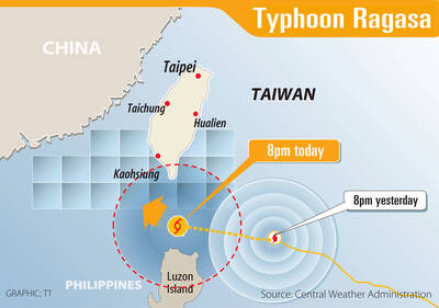
WARNING: People in coastal areas need to beware of heavy swells and strong winds, and those in mountainous areas should brace for heavy rain, the CWA said The Central Weather Administration (CWA) yesterday issued sea and land warnings for Typhoon Ragasa, forecasting that it would continue to intensify and affect the nation the most today and tomorrow. People in Hualien and Taitung counties, and mountainous areas in Yilan and Pingtung counties, should brace for damage caused by extremely heavy rain brought by the typhoon’s outer rim, as it was upgraded to a super typhoon yesterday morning, the CWA said. As of 5:30pm yesterday, the storm’s center was about 630km southeast of Oluanpi (鵝鑾鼻), Taiwan’s southernmost tip, moving northwest at 21kph, and its maximum wind speed had reached
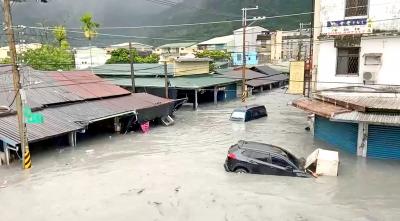
MATAIAN RIVER: Rescue operations were ongoing, with officials urging residents to move to higher floors where possible as teams focus first on those at ground level Floodwaters from the overflowing Mataian River (馬太鞍溪) barrier lake swept into Hualien County’s Guangfu Township (光復) yesterday afternoon, leaving hundreds of people trapped and three missing as of press time last night, the Hualien County Fire Bureau said. The waters surged into downtown Guangfu after the riverbank burst at about 2:50pm, carrying mud and debris and submerging streets to rooftop level in some areas. Residents were seen climbing onto vehicles and rooftops to await rescue as thick, silt-laden water inundated the town. The surge destroyed the Mataian Bridge (馬太鞍溪橋) and flooded the Guangfu Railway Station. Rescue operations were launched with support from fire departments
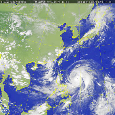
The Central Weather Administration (CWA) yesterday said that it expected to issue a sea warning for Typhoon Ragasa this morning and a land warning at night as it approached Taiwan. Ragasa intensified from a tropical storm into a typhoon at 8am yesterday, the CWA said, adding that at 2pm, it was about 1,110km east-southeast of Oluanpi (鵝鑾鼻), Taiwan’s southernmost tip. The typhoon was moving northwest at 13kph, with sustained winds of up to 119kph and gusts reaching 155kph, the CWA Web site showed. Forecaster Liu Pei-teng (劉沛滕) said that Ragasa was projected to strengthen as it neared the Bashi Channel, with its 200km
PUBLIC ANNOUNCEMENTS: Hualien and Taitung counties declared today a typhoon day, while schools and offices in parts of Kaohsiung and Pingtung counties are also to close Typhoon Ragasa was forecast to hit its peak strength and come closest to Taiwan from yesterday afternoon through today, the Central Weather Administration (CWA) said. Taiwan proper could be out of the typhoon’s radius by midday and the sea warning might be lifted tonight, it added. CWA senior weather specialist Wu Wan-hua (伍婉華) said that Ragasa’s radius had reached the Hengchun Peninsula by 11am yesterday and was expected to hit Taitung County and Kaohsiung by yesterday evening. Ragasa was forecast to move to Taiwan’s southern offshore areas last night and to its southwestern offshore areas early today, she added. As of 8pm last night,