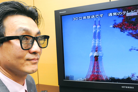
Badminton matches look so real playing on Hyundai’s new 3D TV that you may reflexively dodge the shuttlecock. A polar bear pawing the glass of his tank may seem to be inside the TV pushing on the screen.
Hyundai is offering — in Japan only — the first product for watching the 3D programs that cable stations in Japan now broadcast about four times a day.
PRICEY HOBBY

PHOTO: AP
There are, however, a few catches.
The 46-inch liquid-crystal display requires 3D glasses; it’s expensive — US$3,960, including two pairs of glasses, or about 25 percent more than a comparable regular LCD TV; and the only programs available so far include just a few minutes of video from Japan’s northern island of Hokkaido — shots from the zoo, motorcycle-races and other short scenes.
PLAIN OLD TV
Seen on regular TVs, 3D programs split the screen vertically so the same image appears in both the left and right halves.
Conversely, wearing the 3D glasses while watching regular programming on the Hyundai 3D TV produces a slight 3D effect.
The TV uses stereoscopic technology called TriDef from DDD Group Plc in Santa Monica, California, which works by sending the same image separately for the left eye and the right eye.
Ryo Saito of BS 11, the cable channel that runs the 3D shows, says more content is needed for the technology to catch on, and other manufacturers need to start making 3D televisions.
“People are showing interest in 3D programs, but most homes don’t have the special TVs,” he said.
SAMSUNG
Samsung already sells 3D rear projection TVs in the US, but there are no 3D TV broadcasts in the US. The technology is also available on desktop monitors and for video games.
Hyundai IT is hoping to boost its image by gaining a niche audience in Japan, where the TV market is dominated by Sony Corp and Sharp Corp. The South Korean electronics maker’s 3D TV went on sale in April, but unit sales numbers weren’t available.
There is no plan to sell the TV overseas, Hyundai Japan senior manager Kim Pyeng-joong said.

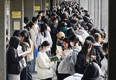
A global survey showed that 60 percent of Taiwanese had attained higher education, second only to Canada, the Ministry of the Interior said. Taiwan easily surpassed the global average of 43 percent and ranked ahead of major economies, including Japan, South Korea and the US, data from the Organisation for Economic Co-operation and Development (OECD) for 2024 showed. Taiwan has a high literacy rate, data released by the ministry showed. As of the end of last year, Taiwan had 20.617 million people aged 15 or older, accounting for 88.5 percent of the total population, with a literacy rate of 99.4 percent, the data

CCP ‘PAWN’? Beijing could use the KMT chairwoman’s visit to signal to the world that many people in Taiwan support the ‘one China’ principle, an academic said Chinese Nationalist Party (KMT) Chairwoman Cheng Li-wun (鄭麗文) yesterday arrived in China for a “peace” mission and potential meeting with Chinese President Xi Jinping (習近平), while a Taiwanese minister detailed the number of Chinese warships currently deployed around the nation. Cheng is visiting at a time of increased Chinese military pressure on Taiwan, as the opposition-dominated Legislative Yuan stalls a government plan for US$40 billion in extra defense spending. Speaking to reporters before going to the airport, Cheng said she was going on a “historic journey for peace,” but added that some people felt uneasy about her trip. “If you truly love Taiwan,

NEW LOW: The council in 2024 based predictions on a pessimistic estimate for the nation’s total fertility rate of 0.84, but last year that rate was 0.69, 17 percent lower An expected National Development Council (NDC) report expects the nation’s population to drop below 12 million by 2065, with the old-age dependency ratio to top 100 percent sooner than 2070, sources said yesterday. The council is slated to release its latest population projections in August, using an ultra-low fertility model, the sources said. The previous report projected that Taiwan’s population would fall to 14.37 million by 2070, but based on a new estimate of the total fertility rate (TFR) — the average number of children born to a woman over her lifetime — the population is expected to reach 12 million by

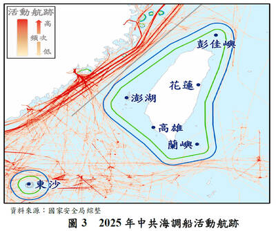
INTENSIFYING THREATS: Beijing’s tactics include massive attacks on the government service network, aircraft and naval vessel incursions and damaging undersea cables China is prepared to interfere in November’s nine-in-one local elections by launching massive attacks on the Taiwanese government’s service network (GSN), a report published by the National Security Bureau showed. The report was submitted to the Legislative Yuan ahead of the bureau’s scheduled briefing at the Foreign Affairs and National Defense Committee tomorrow. The national security team has identified about 13,000 suspicious Internet accounts and 860,000 disputed messages, the bureau said of China’s cognitive warfare against Taiwan. The disputed messages focus on major foreign affairs, national defense and economic issues, which were produced using generative artificial intelligence (AI) and distributed through Chinese