A powerful magnitude 7.6 earthquake shook Japan’s northeast region late on Monday, prompting tsunami warnings and orders for residents to evacuate.
A tsunami as high as three metres (10 feet) could hit Japan’s northeastern coast after an earthquake with an estimated magnitude of 7.6 occurred offshore at 11:15 p.m. (1415 GMT), the Japan Meteorological Agency (JMA) said.
Tsunami warnings were issued for the prefectures of Hokkaido, Aomori and Iwate, and a tsunami of 40cm had been observed at Aomori’s Mutsu Ogawara and Hokkaido’s Urakawa ports before midnight, JMA said.
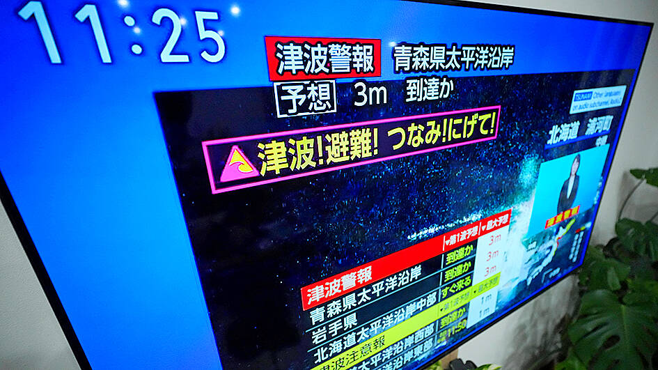
Photo: AP
The epicentre of the quake was 80 km (50 miles) off the coast of Aomori prefecture, at a depth of 50 km (30 miles), the agency added.
Japan is one of the world’s most earthquake-prone countries, with a tremor occurring at least every five minutes.
East Japan Railway suspended some train services in the area, which was also hit by the massive 9.0-magnitude quake in March 2011.
Located in the “Ring of Fire” arc of volcanoes and oceanic trenches partly encircling the Pacific Basin, the country accounts for about 20% of the world’s earthquakes of magnitude 6.0 or greater.
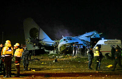
MONEY GRAB: People were rushing to collect bills scattered on the ground after the plane transporting money crashed, which an official said hindered rescue efforts A cargo plane carrying money on Friday crashed near Bolivia’s capital, damaging about a dozen vehicles on highway, scattering bills on the ground and leaving at least 15 people dead and others injured, an official said. Bolivian Minister of Defense Marcelo Salinas said the Hercules C-130 plane was transporting newly printed Bolivian currency when it “landed and veered off the runway” at an airport in El Alto, a city adjacent to La Paz, before ending up in a nearby field. Firefighters managed to put out the flames that engulfed the aircraft. Fire chief Pavel Tovar said at least 15 people died, but
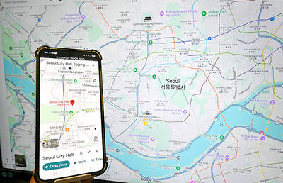
South Korea would soon no longer be one of the few countries where Google Maps does not work properly, after its security-conscious government reversed a two-decade stance to approve the export of high-precision map data to overseas servers. The approval was made “on the condition that strict security requirements are met,” the South Korean Ministry of Land, Infrastructure and Transport said. Those conditions include blurring military and other sensitive security-related facilities, as well as restricting longitude and latitude coordinates for South Korean territory on products such as Google Maps and Google Earth, it said. The decision is expected to hurt Naver and Kakao
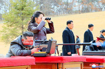
LIKE FATHER, LIKE DAUGHTER: By showing Ju-ae’s ability to handle a weapon, the photos ‘suggest she is indeed receiving training as a successor,’ an academic said North Korea on Saturday released a rare image of leader Kim Jong-un’s teenage daughter firing a rifle at a shooting range, adding to speculation that she is being groomed as his successor. Kim’s daughter, Ju-ae, has long been seen as the next in line to rule the secretive, nuclear-armed state, and took part in a string of recent high-profile outings, including last week’s military parade marking the closing stages of North Korea’s key party congress. Pyongyang’s official Korean Central News Agency (KCNA) released a photo of Ju-ae shooting a rifle at an outdoor shooting range, peering through a rifle scope
Australian Prime Minister Anthony Albanese yesterday said he did not take his security for granted, after he was evacuated from his residence for several hours following a bomb threat sent to a Chinese dance group. Albanese was evacuated from his Canberra residence late on Tuesday following the threat, and returned a few hours later after nothing suspicious was found. The bomb scare was among several e-mails threatening Albanese sent to a representative of Shen Yun, a classical Chinese dance troupe banned in China that is due to perform in Australia this month, a spokesperson for the group said in a statement. The e-mail