

Typhoon Dolphin has moved away from Taiwan and the Central Weather Administration (CWA) has lifted its sea warning for the storm, but southwesterly winds are still forecast to bring heavy rain to central and southern Taiwan in the coming days.
The CWA lifted its sea warning at 11:30pm yesterday after Typhoon Dolphin weakened into a tropical storm and landed in China's Zhejiang Province.
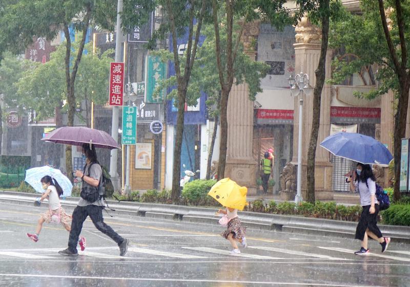
Photo: Wang Yi-sung, Taipei Times
With the storm no longer directly affecting the nation, southwesterly winds and a broad low-pressure system began to dominate Taiwan's weather and would continue to do so over the next week, CWA forecaster Chu Mei-lin (朱美霖) said.
The seasonal winds and low-pressure system are to bring intermittent showers and thunderstorms to central and southern Taiwan and afternoon thunderstorms elsewhere throughout the week, Chu said.
The CWA warned of short-duration heavy rain, lightning, strong wind gusts and rapidly rising stream levels.
Sustained winds of 41kph to 51kph (6 on the Beaufort scale) and gusts of 63kph to 75kph (8 on the Beaufort scale) are forecast today for areas from Chiayi north to Keelung's north coast, as well as the Hengchun Peninsula (恆春半島) in the south, Chu said.
Eastern Taiwan, on the leeward side of the Central Mountain Range, is expected to experience hot weather, she said.
Independent meteorologist Wu Der-rong (吳德榮) said that the unstable weather is likely to persist through Wednesday next week, although the southwesterly winds are expected to weaken after Wednesday.
Meanwhile, three tropical storms and one tropical depression were active over the northwestern Pacific.
Dolphin was continuing to weaken over Zhejiang, while Tropical Storm Chan-hom, the season's 15th named storm, is forecast to approach Japan's main island of Honshu tomorrow and on Wednesday, Wu said.
Tropical Storm Peilou, the 16th storm of the season, is expected to track northeast over the ocean and pose no threat to land, he said.
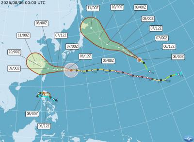
Typhoon Dolphin is expected to enter the East China Sea on Saturday and intensify rainfall in western regions over the weekend as the typhoon’s outer circulation sweeps across the sea north of Taiwan, independent meteorologist Daniel Wu (吳德榮) said today. The eastern coast should prepare for extreme heat caused by downslope winds over the weekend, while southwesterly winds from Monday would bring localized heavy rain to the southwest, he said. As Typhoon Dolphin’s outer bands move past northern Taiwan over the next couple of days, northern, central and southern areas would experience showers tomorrow, he said. Rainfall over the weekend would lead to
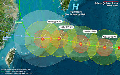
Taiwan could issue a sea warning for Typhoon Dolphin as early as Friday afternoon if the storm maintains its current westward track, the Central Weather Administration (CWA) said yesterday. As of 2pm yesterday, the center of the typhoon was about 2,590km east of Taipei and moving west at 21kph, potentially bringing hazardous conditions to waters surrounding Taiwan by Saturday. Dolphin is expected to reach waters south of the Ryukyu Islands around Saturday, but its track beyond that remains highly uncertain, CWA forecaster Lin Ping-yu (林秉煜) said. The typhoon could either continue moving westward or veer northward, Lin said. A westward track would bring
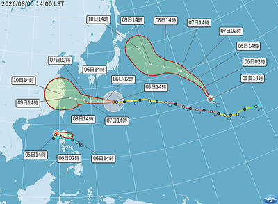
STORM SEASON: A typhoon and two tropical storms currently forming are certainly making life exciting for those living the western Pacific, the CWA said One typhoon and two tropical storms are in the west Pacific, and a sea warning for Typhoon Dolphin could be issued as early as tomorrow afternoon as the storm closes on Taiwan, the Central Weather Administration (CWA) said yesterday. As of 8am yesterday, the center of the typhoon was about 1,680km east of Taipei and moving west at 20kph, the CWA said. Meanwhile, Tropical Storm Kujia formed west of Luzon at 2am yesterday and is forecast to move east of the island before weakening and being absorbed by Typhoon Dolphin, the agency said. Steered by the Pacific high-pressure system, Dolphin is forecast to

EXPANSIONISM: Taiwan has established a cross-agency mechanism to share its experience with other nations to help build a united front against China, Joseph Wu said National Security Council Secretary-General Joseph Wu (吳釗燮) has accused China of using its coast guard and other official vessels to threaten not only Taiwan, but the broader Indo-Pacific region. “The threat posed by China is toward the whole region,” Wu said in an English-language interview with Nikkei Asia published yesterday. The entire First Island Chain, stretching from Japan southward through Taiwan to the Philippines and Malaysia, is facing increasing maritime aggression, he said. Taiwan’s intelligence, surveillance and reconnaissance systems have detected a significant increase in Chinese official vessel activity in the East China Sea, the Taiwan Strait, the western Pacific and the South


 RSS
RSS