


Typhoon Bavi today churned southeast of Taiwan in the Pacific Ocean, its winds easing overnight to just shy of 200kph, as authorities urged residents to stock up on supplies and brace for what could be the most powerful typhoon since 2024.
Bavi is set to be the largest storm by size to hit Taiwan since 1987, Central Weather Administration forecaster Jason Chang said, adding that storms of similar size have been "fairly rare in recent years."
President William Lai (賴清德) wrote on Facebook that people should prepare supplies from food to torches and shared a video teaching people how to put together an emergency grab bag that could give life support for three days.
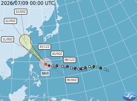
Photo courtesy of the Central Weather Administration
The typhoon is forecast to skirt northern Taiwan before making landfall in China's eastern Fujian Province on Saturday night, China's National Meteorological Center said.
Taiwan, China and Japan are increasingly exposed to destructive weather events that scientists link to climate change. This year is of particular concern because the expected emergence of El Nino could drive up temperatures and help fuel more frequent and intense typhoons.
If Bavi maintains its forecast intensity, it would be the most powerful typhoon since Super Typhoon Kong-rey in 2024, said AccuWeather, a commercial weather forecasting service.
"Some loss of wind intensity is anticipated starting Thursday [today], but Bavi will remain a dangerous storm as it impacts Taiwan and eastern China later Friday into Monday," AccuWeather international forecasting expert Jason Nicholls said.
Japan's meteorological agency urged residents of Okinawa, the country's southernmost prefecture, to remain on high alert tomorrow and on Saturday for violent winds, landslides, flooding and storm surges.
"We should pay much attention to Bavi as it has spent a long time intensifying over the open Pacific, extracting energy from warm ocean and accumulating large amounts of moisture," said Feng Xiangbo (馮翔波), a research scientist in tropical cyclones at Imperial College London.
"When it would make landfall or get close to coastal regions, the damage could be catastrophic. A small change in Bavi's track could have a significant influence," Feng said.
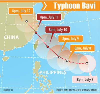
TORRENTIAL: People should be on alert for heavy rain, the CWA said, as Typhoon Bavi is forecast to bring more than 1m of rain to Taiwan Torrential rain brought by Typhoon Bavi is forecast to affect Taiwan most severely on Friday and Saturday, prompting authorities to urge local governments to clear drainage ditches, while nearly 29,000 troops were placed on disaster-prevention standby. As of 2pm yesterday, the typhoon’s center was approximately 1,930km east-southeast of Oluanpi (鵝鑾鼻), Taiwan proper’s southernmost tip, moving west-northwest at 25kph, the Central Weather Administration (CWA) said. Bavi is showing signs of weakening as it approaches Taiwan, although it is still expected to have the intensity of a typhoon, CWA forecaster Lee Meng-hsuan (李孟軒) said. The typhoon has a 350km storm radius, Lee said,
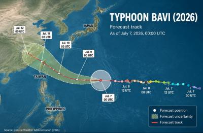
As Typhoon Bavi approaches Taiwan from the southeast, a sea warning is expected to be issued on Thursday, followed by a land warning on either Thursday evening or Friday morning, the Central Weather Administration (CWA) said today. With a relatively wide radius of 350km, the typhoon is expected to affect a wide swathe of the country as it passes by to the north, bringing the heaviest rain on Friday and Saturday, when its path tracks closest to Taiwan, the weather agency said. Torrential rain is forecast in mountainous regions north of Taichung on Friday and Saturday, while heavy rain is also
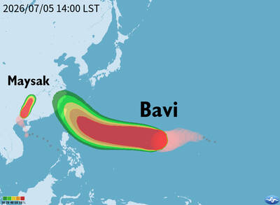
Typhoon Bavi is expected to make its closest approach to Taiwan on Friday and Saturday, with a sea warning likely to be issued as the storm approaches, the Central Weather Administration (CWA) said yesterday. As of 2pm, the eye of the typhoon was about 3,030km east-southeast of Oluanpi (鵝鑾鼻), Taiwan’s southernmost tip, and moving west-northwest at 17kph, the CWA said. The storm, which has a radius of 320km, had maximum sustained winds of 198kph near its center, it said. CWA forecaster Lai Hsin-kuo (賴欣國) said Bavi is expected to strengthen further today, with maximum sustained winds reaching 227kph and its

Taiwan yesterday stepped up preparations for Typhoon Bavi, suspending ferry services to outlying islands, closing tourist attractions, preparing traffic restrictions and offering flexible airline ticket changes. As of 2pm yesterday, Bavi was about 1,380km east-southeast of Oluanpi (鵝鑾鼻), Taiwan’s southernmost point, moving west-northwest at 17kph to 21kph, the Central Weather Administration (CWA) said. All ferry services in eastern Taiwan were suspended yesterday afternoon, the Maritime and Port Bureau said. Services could resume on Sunday, if the weather permits, it added. The Keelung-Matsu route is also to be suspended from today through Saturday, while routes linking Kaohsiung and Budai (布袋) with Penghu, as well as


 RSS
RSS