


Taiwan’s preparations to deal with a possible Chinese attack are not a provocation, and Taiwanese need to take the threat seriously and prepare, National Security Council Deputy Secretary-General Lin Fei-fan (林飛帆) said yesterday.
Taiwan’s government, which rejects Beijing’s sovereignty claims, has been increasing military spending and regularly holding civil defence drills under what President William Lai (賴清德) refers to as whole-of-society resilience efforts.
Speaking at a forum in Taipei, Lin, who oversees the resilience program, said China’s massive defense spending and its ongoing military pressure in the region are real threats.

Photo: Reuters
“People often portray Taiwan’s preparations as provocation toward the other side,” he said. “I want to take this opportunity to tell everyone: all of China’s preparations have one clear goal — military aggression and external expansion.”
Lin said Beijing’s actions are the opposite of Taipei’s.
“A country that advocates ‘the two sides of the strait are one family’ does not need to test-fire missiles and rockets in the Taiwan Strait,” he added. “Taiwan today does not fly a single aircraft or send a single warship to intrude into the other side’s airspace or waters. The one provoking the regional order is not anyone else — it is China.”
Lin said that given the danger posed, government efforts to get people ready for conflict are vital, and said it was wrong to look at what was happening with the war in Ukraine and think it could not happen in Taiwan.
“If we do not act today, strength will not suddenly appear tomorrow,” he added. “If we do not conduct drills today, when a crisis arrives, we may not even know the most basic standard operating procedure.”
There would be immediate peace if China were to give up its military ambitions toward Taiwan, Lin said. “But if Taiwan now gives up its ability to defend itself, there will no longer be a Taiwan in the world.”
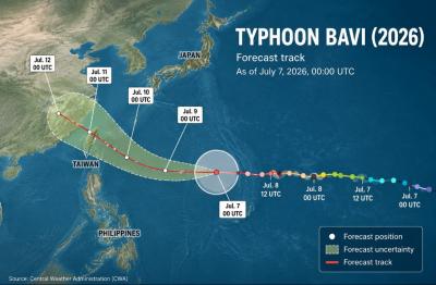
As Typhoon Bavi approaches Taiwan from the southeast, a sea warning is expected to be issued on Thursday, followed by a land warning on either Thursday evening or Friday morning, the Central Weather Administration (CWA) said today. With a relatively wide radius of 350km, the typhoon is expected to affect a wide swathe of the country as it passes by to the north, bringing the heaviest rain on Friday and Saturday, when its path tracks closest to Taiwan, the weather agency said. Torrential rain is forecast in mountainous regions north of Taichung on Friday and Saturday, while heavy rain is also
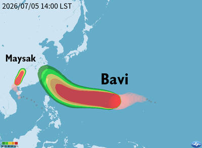
Typhoon Bavi is expected to make its closest approach to Taiwan on Friday and Saturday, with a sea warning likely to be issued as the storm approaches, the Central Weather Administration (CWA) said yesterday. As of 2pm, the eye of the typhoon was about 3,030km east-southeast of Oluanpi (鵝鑾鼻), Taiwan’s southernmost tip, and moving west-northwest at 17kph, the CWA said. The storm, which has a radius of 320km, had maximum sustained winds of 198kph near its center, it said. CWA forecaster Lai Hsin-kuo (賴欣國) said Bavi is expected to strengthen further today, with maximum sustained winds reaching 227kph and its
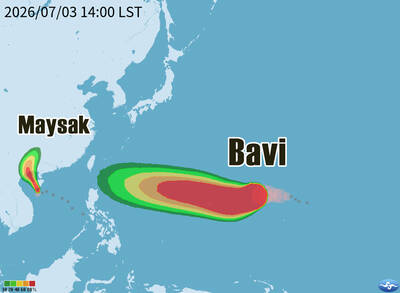
TWO STORMS: Typhoon Bavi was 3,670km from Taiwan, with models showing diverging tracks for it, while a second storm was expected to not affect Taiwan at all Typhoon Bavi, which was moving westward over waters east of the Philippines, was showing signs of strengthening, although its potential impact on Taiwan was uncertain, the Central Weather Administration (CWA) said yesterday. As of 2pm, the center of the storm was 3,670km east of Oluanpi (鵝鑾鼻), Taiwan proper’s southernmost tip, moving westward and slowing to 11kph from about 15kph, CWA data showed. It had maximum sustained winds of up to 155kph near its center, with gusts of up to 191kph, the data showed. Due to environmental conditions, the CWA said that Bavi was expected to continue to strengthen in the next few days. Forecasts
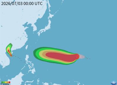
Typhoon Bavi, which is moving westward over waters east of the Philippines, is showing signs of intensifying, though its potential impact on Taiwan remains uncertain, the Central Weather Administration (CWA) said today. As of 8am, the center of the storm was 3,800km east-southeast of Oluanpi (鵝鑾鼻), on the southernmost tip of Taiwan, moving westward but slowing from 16kph to 13kph, CWA data showed. It was packing maximum sustained winds of up to 137kph near its center, with gusts of up to 173kph, the weather agency said. Due to environmental conditions, Bavi is expected to continue strengthening in the coming days, the CWA said. The


 RSS
RSS