The Ministry of Science and Technology yesterday announced plans to focus on the development of 10 small, high-resolution satellites for the third phase of the National Space Program.
The third phase, which is expected to cost NT$25.1 billion (US$814 million), was last month approved by Premier Su Tseng-chang (蘇貞昌).
It was the first official document he signed after taking office.
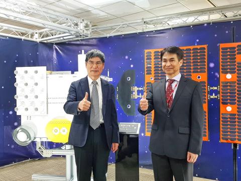
Photo: Chien Hui-ju, Taipei Times
It is to be executed by the National Applied Research Laboratories and the National Space Organization (NSPO) over a 10-year period starting this year, the ministry said.
The initiative would focus on the development of six prototype high-resolution optical remote sensing satellites, two ultra-high resolution smart optics remote sensing satellites and two synthetic aperture radar (SAR) satellites, it said.
It would also focus on the development of remote sensing technology and the use of smaller satellites to achieve higher resolution images, Minister of Science and Technology Chen Liang-gee (陳良基) said.
Citing an example, Chen said an ultra-high resolution smart optics remote sensing satellite weighing about 200kg would give users a 35cm view of the ground from an altitude of 510km, which would be the equivalent of spotting a cat or a dog in Pingtung County’s Kenting (墾丁) area from the Taipei 101 building.
The ministry plans to launch one satellite a year, he said, adding that the first is expected to be launched in 18 months.
The achievements of the first and second phases would serve as the foundation for the third phase, Chen said.
He hopes that the National Space Program would encourage innovation in the field of science, he added.
The prototype high-resolution optical remote sensing satellite constellation, which is to include three sets of two satellites, would raise the frequency of Formosat-5’s revisit rate from once every two days to twice or three times a day, NSPO director-general Lin Chun-liang (林俊良) said.
This would allow the ministry to gather more images, which has positive implications for the implementation of government policies, rescue missions, disaster prevention and scientific research, he said.
Ultra-high resolution smart optics remote sensing satellites focus on sub-meter resolution images, Lin said.
SAR satellites, which are equipped with active radar, are unaffected by cloud cover, fog or rainfall, which means they can function no matter the weather conditions or time of day, he said.
Other plans for the third phase include space exploration and the development of a satellite capable of orbiting the moon, Lin added.
As Taiwan lacks experience in these areas, it hopes to achieve its goal of space exploration by partnering with domestic and foreign academia, he said.
Having a satellite orbiting the moon would be the first step, he said.
Researchers would also explore ways to land a satellite on the moon, Lin added.
Without the assistance of GPS on the moon, the satellite would need to guide its own landing, he said.
Asked about the launch date of Formosat-7, Lin said that as Taiwan is partnering with the US for the launch, it would need to wait for the US to notify them.
Formosat-7’s six satellites are on standby at the NSPO, and can be packaged and delivered to the US as soon as it receives notice from the US, he said.
The ministry plans to launch Formosat-7 this year and a weather satellite called the “wind hunter” next year, Chen said.
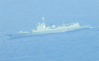
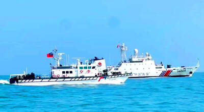
The military has spotted two Chinese warships operating in waters near Penghu County in the Taiwan Strait and sent its own naval and air forces to monitor the vessels, the Ministry of National Defense (MND) said. Beijing sends warships and warplanes into the waters and skies around Taiwan on an almost daily basis, drawing condemnation from Taipei. While the ministry offers daily updates on the locations of Chinese military aircraft, it only rarely gives details of where Chinese warships are operating, generally only when it detects aircraft carriers, as happened last week. A Chinese destroyer and a frigate entered waters to the southwest
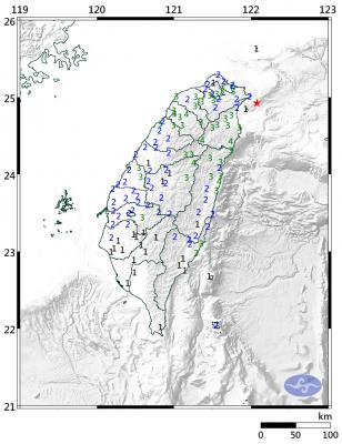
A magnitude 6.1 earthquake struck off the coast of Yilan County at 8:39pm tonight, the Central Weather Administration (CWA) said, with no immediate reports of damage or injuries. The epicenter was 38.7km east-northeast of Yilan County Hall at a focal depth of 98.3km, the CWA’s Seismological Center said. The quake’s maximum intensity, which gauges the actual physical effect of a seismic event, was a level 4 on Taiwan’s 7-tier intensity scale, the center said. That intensity level was recorded in Yilan County’s Nanao Township (南澳), Hsinchu County’s Guansi Township (關西), Nantou County’s Hehuanshan (合歡山) and Hualien County’s Yanliao (鹽寮). An intensity of 3 was
Instead of focusing solely on the threat of a full-scale military invasion, the US and its allies must prepare for a potential Chinese “quarantine” of Taiwan enforced through customs inspections, Stanford University Hoover fellow Eyck Freymann said in a Foreign Affairs article published on Wednesday. China could use various “gray zone” tactics in “reconfiguring the regional and ultimately the global economic order without a war,” said Freymann, who is also a nonresident research fellow at the US Naval War College. China might seize control of Taiwan’s links to the outside world by requiring all flights and ships entering or leaving Taiwan
The next minimum wage hike is expected to exceed NT$30,000, President William Lai (賴清德) said yesterday during an award ceremony honoring “model workers,” including migrant workers, at the Presidential Office ahead of Workers’ Day today. Lai said he wished to thank the awardees on behalf of the nation and extend his most sincere respect for their hard work, on which Taiwan’s prosperity has been built. Lai specifically thanked 10 migrant workers selected for the award, saying that although they left their home countries to further their own goals, their efforts have benefited Taiwan as well. The nation’s industrial sector and small businesses lay