Typhoon Nanmadol last night made landfall in southwestern Japan, as authorities urged millions of people to take shelter from the storm’s winds and torrential rain.
The storm officially made landfall at about 7pm as its eyewall arrived near Kagoshima city, the Japan Meteorological Agency said.
It was packing gusts of up to 234kph and had already dumped up to 500mm of rain in less than 24 hours on parts of southwestern Kyushu.

Photo: AP
At least 20,000 people were spending the night in shelters in Kyushu’s Kagoshima and Miyazaki prefectures, where the agency issued a rare “special warning” — an alert that is issued only when conditions are forecast that are expected once in several decades.
National broadcaster NHK, which collates information from local authorities, said more than 7 million people had been told to move to shelters or take refuge in sturdy buildings to ride out the storm.
The evacuation warnings are not mandatory, and authorities have at times struggled to convince people to move to shelters before extreme weather.
They sought to drive home their concerns about the weather system throughout the weekend.
“Please stay away from dangerous places, and please evacuate if you feel even the slightest hint of danger,” Japanese Prime Minister Fumio Kishida wrote on Twitter after convening a government meeting on the storm. “It will be dangerous to evacuate at night. Please move to safety while it’s still light outside.”
The agency has warned the region could face “unprecedented” danger from high winds, storm surges and torrential rain, and called the storm “very dangerous.”
“Areas affected by the storm are seeing the sort of rain that has never been experienced before,” Hiro Kato, the head of the Weather Monitoring and Warning Center, told reporters. “Especially in areas under landslide warnings, it is extremely probable that some kinds of landslides are already happening.”
He urged “maximum caution even in areas where disasters do not usually happen.”
By yesterday evening, utility companies said nearly 200,000 homes across the region were without power.
Trains, flights and ferry services were canceled until the passage of the storm, and even some convenience stores — generally open all hours and considered a lifeline in disasters — were shutting their doors.
In Taipei, the Central Weather Bureau on Saturday said the typhoon would not affect Taiwan other than bringing brief localized rain to some regions.
Northerly winds would bring moisture from Nanmadol’s periphery and increase cloud formation, bringing brief showers to northern, eastern and southeastern Taiwan, as well as localized downpours to eastern and southeastern regions, it said.
It would mostly be sunny to cloudy in other regions, but eastern Taiwan and mountainous areas might see brief, localized thundershowers, and central and southern Taiwan might see brief showers, it added.
Additional reporting by CNA
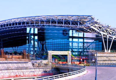
‘NO SECURITY RISK’: The Railway Bureau reassured the public that the technicians’ activities were limited to technical guidance and did not involve sensitive systems The Railway Bureau yesterday said it had invited eight Chinese technicians to assist with an airport MRT construction project. The bureau issued the confirmation after an Internet user said Chinese nationals had entered the construction zone of Taiwan Taoyuan International Airport’s Terminal 3 project. They asked why “individuals from an enemy state” were allowed access to such a major national infrastructure project, which raised serious concerns over Taiwan’s industrial safety, sensitive systems and information security. The bureau’s Northern Region Engineering Branch Office said subcontractor Taiwan Handle Industrial Co (台灣手把工業) of the Taoyuan airport MRT’s “Contract No. CU05 Project A14 Station Civil, MEP &
A US uncrewed surface vessel (USV) encountered multiple Chinese warships during an autonomous transit of the Taiwan Strait, US defense company Seasats said in a statement on Wednesday. Seasats announced that a Lightfish USV had completed the first autonomous transit of the Taiwan Strait. Over five days, the USV traversed the entire length of the Strait while constantly monitoring surface vessel traffic, the company said. The Lightfish encountered multiple Chinese warships, one of which was a Chinese People’s Liberation Army Navy (PLAN) Type 056 corvette, it said. The Chinese vessels were operating “well within Taiwan’s exclusive economic zone without transmitting their identity via the

‘BOOMING’: ’ The number of partners we have here is incredible. You can see from their stock prices. They’re doing so well, they’re so happy,’ Jensen Huang said Nvidia Corp’s spending in Taiwan has ballooned to about US$150 billion a year, 10 times the US$10 billion to US$15 billion the company spent five years ago, Nvidia chief executive officer Jensen Huang (黃仁勳) said yesterday, suggesting Taiwan’s strategic importance in the global artificial intelligence (AI) supply chain. “Taiwan is the epicenter of the AI revolution. This is where the chips come, packaging comes. This is where the systems are made. This is where AI supercomputers were created,” Huang said at a meeting for the company’s employees in Beitou-Shilin Technology Park (北投士林科技園區) in Taipei, the planned site of Nvidia’s Taipei headquarters. “Taiwan
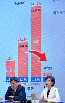
GREATER REACH? Auto parts and wood products would face tariffs of up to 15%, matching those targeting the EU, Japan and South Korea, Vice Premier said The US has announced that preferential tariff treatment for Taiwan’s non-semiconductor Section 232 goods would take effect retroactively from May 1, the Executive Yuan said yesterday. The US government yesterday posted a notice on the Federal Register’s public inspection Web site previewing tariff concessions for Taiwan under a memorandum of understanding (MOU) on Taiwan-US investment after two months of negotiations. The MOU signed on Jan. 15 stipulated three major preferential tariff arrangements: a 15 percent “reciprocal” tariff rate for Taiwan without stacking most-favored nation (MFN) rates; preferential Section 232 treatment for semiconductors and related products; and preferential Section 232 treatment for non-semiconductor