Extreme torrential rain brought by a southwesterly jet stream yesterday wreaked havoc in central and southern Taiwan, causing flash floods and triggering mudflows and landslides in mountainous areas.
By 5pm yesterday, the Central Weather Bureau’s observation station in Yuyoushan (御油山) in Kaohsiung’s Liouguei District (六龜) had registered accumulated rainfall of 726.5mm since 12am on Saturday, the highest among the bureau’s observation stations.
It was followed by the observation station in Kaohsiung’s Maolin District (茂林), which recorded accumulated rainfall of 671.5mm over the period.
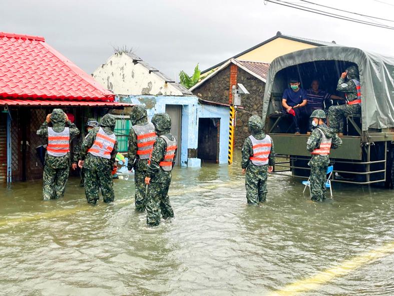
Photo courtesy of the army via CNA
Six of the 10 observation stations that recorded the highest accumulated rainfall yesterday were in Liouguei, bureau data showed.
The Kaohsiung City Government had on Saturday night made an emergency announcement canceling work and classes yesterday in anticipation of torrential rain.
Kaohsiung Mayor Chen Chi-mei (陳其邁) yesterday visited Yongan District (永安) and two other locations hit by flash floods triggered by the rain.
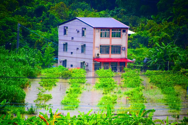
Photo: Su Fu-nan, Taipei Times
He said the city has secured a budget of NT$350 million (US$12.52 million) to improve a local drainage system, adding that flooding in Yongan would be addressed once construction is completed by the end of next year.
Flash floods were also reported in Tainan, as well as Changhua, Yunlin, Chiayi and Pingtung counties.
Bureau forecaster Liu Yu-chi (劉宇其) said the rain brought by the southwesterly jet stream fell mostly in areas south of Taichung.
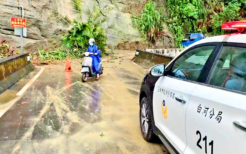
Photo courtesy of Tainan City Police Department’s Baihe Precinct
In addition to continuous rainfall, residents in these areas also experienced short bursts of intense rainfall, Liu said, adding that 90mm of rain fell within one hour in mountainous areas in Tainan and Pingtung County.
Although the rains in central and southern Taiwan would gradually ease, as the southwest jet stream turned south last night, chances of heavy or extremely heavy rain remain high this morning, Liu said.
Southwesterly winds would remain strong and continue to affect the nation this week, he said, adding that people should beware of disasters caused by heavy or extremely heavy rain.
Winds in the coastal areas could reach level 8 or 9 on the Beaufort scale, Liu added.
From today to Saturday, showers or thundershowers have been forecast for central and southern Taiwan due to the influence of southwesterly winds and a low-pressure system. Heavy to extremely heavy rainfall has been forecast in mountainous areas today and tomorrow.
From Sunday to Tuesday next week, the weather would be unstable due to the influence of a low-pressure system, with brief showers and thundershowers nationwide, the bureau said.
A southwest jet stream is a flow of warm and humid air from the Indian Ocean and the South China Sea brought by the southwest monsoon.
It arrives in the nation after typhoons move away from Taiwan. The warm and humid air rises after encountering the Central Mountain Range and dumps rain in central and southern Taiwan.

PROVOCATIVE: Chinese Deputy Ambassador to the UN Sun Lei accused Japan of sending military vessels to deliberately provoke tensions in the Taiwan Strait China denounced remarks by Japan and the EU about the South China Sea at a UN Security Council meeting on Monday, and accused Tokyo of provocative behavior in the Taiwan Strait and planning military expansion. Ayano Kunimitsu, a Japanese vice foreign minister, told the Council meeting on maritime security that Tokyo was seriously concerned about the situation in the East China and South China seas, and reiterated Japan’s opposition to any attempt to change the “status quo” by force, and obstruction of freedom of navigation and overflight. Stavros Lambrinidis, head of the EU delegation to the UN, also highlighted South China Sea
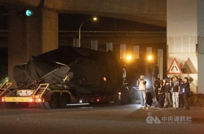
The final batch of 28 M1A2T Abrams tanks purchased from the US arrived at Taipei Port last night and were transported to the Armor Training Command in Hsinchu County’s Hukou Township (湖口), completing the military’s multi-year procurement of 108 of the tanks. Starting at 12:10am today, reporters observed more than a dozen civilian flatbed trailers departing from Taipei Port, each carrying an M1A2T tank covered with black waterproof tarps. Escorted by military vehicles, the convoy traveled via the West Coast Expressway to the Armor Training Command, with police implementing traffic control. The army operates about 1,000 tanks, including CM-11 Brave Tiger

Taiwan Semiconductor Manufacturing Co (TSMC, 台積電), the world’s largest contract chipmaker, said it expects its 2-nanometer (2nm) chip capacity to grow at a compound annual rate of 70 percent from this year to 2028. The projection comes as five fabs begin volume production of 2-nanometer chips this year — two in Hsinchu and three in Kaohsiung — TSMC senior vice president and deputy cochief operating officer Cliff Hou (侯永清) said at the company’s annual technology symposium in Silicon Valley, California, last week. Output in the first year of 2-nanometer production, which began in the fourth quarter of last year, is expected to
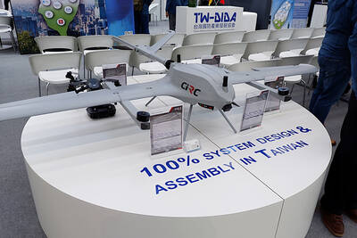
Taiwan’s drone exports surged past US$100 million in the first quarter, exceeding last year’s full-year total, with the Czech Republic emerging as the largest buyer, the Ministry of Economic Affairs said. Exports of complete drones reached US$115.85 million in the period, about 1.2 times the total recorded for all of last year, the ministry said in a report. Exports to the Czech Republic accounted for about US$100 million, far outpacing other markets. Poland, last year’s top destination, recorded about US$11.75 million in the first quarter. Taiwan’s drone exports have expanded rapidly in the past few years, with last year’s total