FORMOSAT-2, the nation’s first locally developed ionospheric research and surface mapping satellite, has been decommissioned after 12 years in operation.
The satellite had remained operational eight years past its expected lifespan of five years, but a series of equipment failures finally forced the National Space Organization (NSPO) to pull the plug.
One of its four reaction wheels, which rotate and position the satellite, malfunctioned in 2013, and another one stopped working in June, which meant FORMOSAT-2 could no longer take pictures or make observations, the agency said.
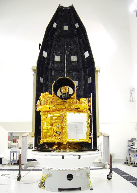
Photo courtesy of the National Space Organization
After weeks of repair efforts, the NSPO determined that the problematic wheels could not be fixed and that FORMOSAT-2 had to be retired.
The agency made its last contact with FORMOSAT-2 during a decommissioning ceremony on Friday at its headquarters in Hsinchu, bringing an end to the nation’s most successful surveillance satellite program.
“With gratitude, we congratulate FORMOSAT-2 for the service it provided. It accompanied us over the past 12 years as we grew up. It is like an old friend, or more like a teacher,” NSPO Director Chang Guey-shin (張桂祥) said. “The satellite made an unparalleled contribution to the nation’s space development.”
The satellite, which cost NT$4.6 billion (US$145.5 million at current exchange rates) to build, was launched on May 21, 2004, from Vandenberg Air Force Base in California.
It circles the Earth once every 103 minutes and passes over Taiwan twice a day.
It was the nation’s only satellite with a daily revisit capability, meaning it could take pictures of a given location every day, and the only one that could photograph the polar regions.
The satellite took about 2.55 million pictures of the Earth’s surface.
The pictures brought in about NT$600 million in revenue, while images worth about NT$1.1 billion were provided to 191 government agencies and 176 academic institutions in Taiwan free of charge.
The satellite helped with scientific research, environmental monitoring, urban planning and natural disaster prevention and evaluation.
FORMOSAT-2 was used in 343 disaster response missions, providing authorities with immediate images of damaged areas during the Indian Ocean earthquake and tsunami in December 2004, Hurricane Katrina in the US in 2005, the Sichuan earthquake in China in 2008, Typhoon Morakot in Taiwan in 2009 and the Tohoku earthquake and tsunami in Japan in 2011.
For eight days after Morakot hit Taiwan, the satellite took detailed pictures of all areas damaged by the typhoon to help the government evaluate the situation and plan its emergency response.
FORMOSAT-2 was also the first satellite to observe the transient luminous event — an electrical-discharge phenomena well above the altitudes of normal lightning and storm clouds — and its observations have been cited in numerous academic research.
Additional reporting by staff writer

Tropical Storm Gaemi strengthened into a typhoon at 2pm yesterday, and could make landfall in Yilan County tomorrow, the Central Weather Administration (CWA) said yesterday. The agency was scheduled to issue a sea warning at 11:30pm yesterday, and could issue a land warning later today. Gaemi was moving north-northwest at 4kph, carrying maximum sustained winds near its center of up to 118.8kph and gusts of 154.8kph. The circumference is forecast to reach eastern Taiwan tomorrow morning, with the center making landfall in Yilan County later that night before departing from the north coast, CWA weather forecaster Kuan Shin-ping (官欣平) said yesterday. Uncertainty remains and

SEA WARNING LIKELY: The storm, named Gaemi, could become a moderate typhoon on Wednesday or Thursday, with the Taipei City Government preparing for flooding A tropical depression east of the Philippines developed into a tropical storm named Gaemi at 2pm yesterday, and was moving toward eastern Taiwan, the Central Weather Administration (CWA) said. Gaemi could begin to affect Taiwan proper on Tuesday, lasting until Friday, and could develop into a moderate typhoon on Wednesday or Thursday, it said. A sea warning for Gaemi could be issued as early as Tuesday morning, it added. Gaemi, the third tropical storm in the Pacific Ocean this typhoon season, is projected to begin moving northwest today, and be closest to Taiwan on Wednesday or Thursday, the agency said. Today, there would likely

DISRUPTIONS: The high-speed rail is to operate as normal, while several airlines either canceled flights or announced early departures or late arrivals Schools and offices in 15 cities and counties are to be closed today due to Typhoon Gaemi, local governments announced last night. The 15 are: Taipei, New Taipei City, Taoyuan, Tainan, Keelung, Hsinchu and Kaohsiung, as well as Yilan, Hualien, Hsinchu, Miaoli, Chiayi, Pingtung, Penghu and Lienchiang counties. People should brace for torrential rainfall brought by the storm, with its center forecast to make landfall on the east coast between tonight and tomorrow morning, the Central Weather Administration (CWA) said. The agency issued a sea warning for the typhoon at 11:30pm on Monday, followed by a land warning at 11:30am yesterday. As of

CASUALTY: A 70-year-old woman was killed by a falling tree in Kaohsiung as the premier warned all government agencies to remain on high alert for the next 24 hours Schools and offices nationwide are to be closed for a second day today as Typhoon Gaemi crosses over the nation, bringing torrential rain and whipping winds. Gaemi was forecast to make landfall late last night. From Tuesday night, its outer band brought substantial rainfall and strong winds to the nation. As of 6:15pm last night, the typhoon’s center was 20km southeast of Hualien County, Central Weather Administration (CWA) data showed. It was moving at 19kph and had a radius of 250km. As of 3pm yesterday, one woman had died, while 58 people were injured, the Central Emergency Operation Center said. The 70-year-old