The Central Weather Bureau yesterday issued sea and land alerts for Typhoon Nepartak, adding that the storm is likely to make landfall on the east coast and severely affect the nation’s weather today and tomorrow.
By 8:30pm yesterday, the eye of the typhoon was 700km southeast of Hualien. The typhoon was moving northwest at 20kph, with the radius of the storm expanding to 200km. The maximum wind speed near the typhoon’s eye was 209kph.
The sea alert, which was issued at 2:30pm, applies to vessels operating near Orchid Island (蘭嶼, also known as Lanyu), Green Island (綠島), the northeast and southeast coasts of Taiwan proper, as well as the Bashi Channel.
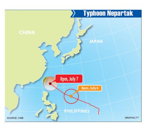
Based on the bureau’s projected path, the typhoon is forecast to make landfall between Hualien and Taitung. It would then move across central Taiwan and the west coast before leaving via the Taiwan Strait.
Bureau forecaster Chen Yi-liang (陳怡良) said that the typhoon is likely to affect the nation from the latter half of today and all day tomorrow, adding that that the radius of the storm could reach Taiwan by this afternoon.
The entire nation — Taiwan proper and the outlying islands of Penghu, Kinmen and Matsu, should be prepared for stormy weather.

Photo: Wang Chun-chi, Taipei Times
Strong winds and large waves would affect the north and east coasts, as well as Hengchun Peninsula, Chen said, adding that people planning to visit these areas should be aware of the risks to their safety.
While the typhoon had yet to arrive yesterday, vegetable prices were reported to have risen by an average of 20 percent yesterday as consumers stocked up on food and vegetables before markets closed due to the typhoon, the Agriculture and Food Agency said, adding that the nation has a sufficient supply of vegetables.
Meanwhile, Taoyuan International Airport Corp said that it has ensured that drainage pipeline H would be functioning when the typhoon strikes in a bid to prevent flooding from recurring at Taiwan Taoyuan International Airport, adding that it is also equipped with several water pumps and 6,000 sandbags.

Photo: CNA
However, the airport advised passengers to contact their airlines directly to check if their flights today or tomorrow would be canceled or postponed due to the arrival of the typhoon, adding that the airport would process any backlog of flights over the weekend after the typhoon moves away from Taiwan.
Mandarin Airlines (華信航空), TransAsia Airways (復興航空) and Air China (中國國際航空) announced yesterday evening that some of their flights to China, northeast Asia and southeast Asia had been either canceled or postponed.
Shipping services to Orchid Island, Matsu, Penghu, Okinawa and Pingtan in China’s Fujian Province have also been canceled today.

Photo: Liao Chen-hui, Taipei Times
Taiwan High Speed Rail Corp announced that its services departing before 5pm today would operate as scheduled, adding that an announcement about trains departing after 5pm would be made at 8am today.
Taiwan Railways Administration passengers and other public transport users were advised to monitor any announcements about delays or cancelations of services.
As of press time last night, eight cities and counties had announced that today would be a regular working day — Keelung, Taipei, New Taipei City and Taoyuan, and Hsinchu, Changhua, Chiayi and Lienchiang counties, while the other local governments were yet to make an announcement.

Tropical Storm Gaemi strengthened into a typhoon at 2pm yesterday, and could make landfall in Yilan County tomorrow, the Central Weather Administration (CWA) said yesterday. The agency was scheduled to issue a sea warning at 11:30pm yesterday, and could issue a land warning later today. Gaemi was moving north-northwest at 4kph, carrying maximum sustained winds near its center of up to 118.8kph and gusts of 154.8kph. The circumference is forecast to reach eastern Taiwan tomorrow morning, with the center making landfall in Yilan County later that night before departing from the north coast, CWA weather forecaster Kuan Shin-ping (官欣平) said yesterday. Uncertainty remains and

SEA WARNING LIKELY: The storm, named Gaemi, could become a moderate typhoon on Wednesday or Thursday, with the Taipei City Government preparing for flooding A tropical depression east of the Philippines developed into a tropical storm named Gaemi at 2pm yesterday, and was moving toward eastern Taiwan, the Central Weather Administration (CWA) said. Gaemi could begin to affect Taiwan proper on Tuesday, lasting until Friday, and could develop into a moderate typhoon on Wednesday or Thursday, it said. A sea warning for Gaemi could be issued as early as Tuesday morning, it added. Gaemi, the third tropical storm in the Pacific Ocean this typhoon season, is projected to begin moving northwest today, and be closest to Taiwan on Wednesday or Thursday, the agency said. Today, there would likely

DISRUPTIONS: The high-speed rail is to operate as normal, while several airlines either canceled flights or announced early departures or late arrivals Schools and offices in 15 cities and counties are to be closed today due to Typhoon Gaemi, local governments announced last night. The 15 are: Taipei, New Taipei City, Taoyuan, Tainan, Keelung, Hsinchu and Kaohsiung, as well as Yilan, Hualien, Hsinchu, Miaoli, Chiayi, Pingtung, Penghu and Lienchiang counties. People should brace for torrential rainfall brought by the storm, with its center forecast to make landfall on the east coast between tonight and tomorrow morning, the Central Weather Administration (CWA) said. The agency issued a sea warning for the typhoon at 11:30pm on Monday, followed by a land warning at 11:30am yesterday. As of

CASUALTY: A 70-year-old woman was killed by a falling tree in Kaohsiung as the premier warned all government agencies to remain on high alert for the next 24 hours Schools and offices nationwide are to be closed for a second day today as Typhoon Gaemi crosses over the nation, bringing torrential rain and whipping winds. Gaemi was forecast to make landfall late last night. From Tuesday night, its outer band brought substantial rainfall and strong winds to the nation. As of 6:15pm last night, the typhoon’s center was 20km southeast of Hualien County, Central Weather Administration (CWA) data showed. It was moving at 19kph and had a radius of 250km. As of 3pm yesterday, one woman had died, while 58 people were injured, the Central Emergency Operation Center said. The 70-year-old