A new map to be released later this month by China’s National Administration of Surveying, Mapping and Geoinformation increases from 29 to 130 the number of disputed areas marked as officially part of the People’s Republic of China (PRC), including the Diaoyutai Islands (釣魚台) claimed by Taiwan and Japan.
Previous editions of the “Wall Map Series of National Territory,” which presented China’s claimed territory in horizontal format, only included the larger contested islands in the South China Sea in a separate box at the bottom right of the map, Xinhua news agency said at the weekend. The territories included in the box were half scale and not clearly detailed.
The new map is vertical and is to be distributed by Sinomaps Press on behalf of the Chinese authorities starting next month. It will for the first time display the entirety of the PRC’s claimed territory on the same scale as continental China.
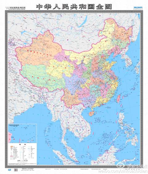
Photo from stcn.com
“The new map will be very significant in enhancing Chinese people’s awareness of national territory, safeguarding China’s marine rights and interests and manifesting China’s political diplomatic stance,” Xu Gencai (徐根才), editor-in-chief at Sinomaps Press, told Xinhua.
In all, the map includes 130 disputed areas, including Taiwan, islets and coral reefs in the Spratlys (Nansha Islands, 南沙群島), the Paracels (Xisha Islands, 西沙群島), the Pratas (Dongshan Islands, 東沙群島), the Macclesfield Bank (Zhongsha Islands, 中沙群島) and the Scarborough Shoal (Huangyan Island (黃岩島), which are the object of disputes between Taiwan, China, the Philippines, Vietnam, Brunei and Malaysia. It also includes the Diaoyutais, in the East China Sea.
In another first, an inset shows the northern tip of Taiwan and detailed mapping of the eight major islets comprising the Diaoyutais, known as the Senkakus by Japan.
Tensions in the area escalated last week, with China and Japan dispatching fighter aircraft after Chinese aircraft penetrated Japan’s Air Defense Identification Zone near the islets on three occasions.
Lu Chang-shui (盧長水), head of the Mainland Affairs Council’s Department of Information and Liaison, said the map was different from the one in new Chinese passports showing Taiwan and the South China Sea as Chinese territory, as well as pictures of Taiwanese tourist spots.
“A passport represents national sovereignty and a map is for a country’s internal use,” Lu said. “Consequently, the council will use different approaches to deal with the map and the passport.”
Lu added that official maps published by the government include the PRC as part of Republic of China (ROC) territory, as dictated by the ROC Constitution.
In related developments, state broadcaster NHK reported yesterday that Japan would deploy two additional patrol ships at its regional coast guard headquarters responsible for territory that includes the Senkakus.
The 335-tonne Kurose and the 3,100-tonne Chikuzen, which comes equipped with a helicopter, will be deployed in August and October respectively, it said.
Meanwhile, during a meeting in Sydney on Sunday, Japanese Minister of Foreign Affairs Fumio Kishida and Australian Minister of Foreign Affairs Bob Carr told a press conference that the two countries had agreed to increase bilateral cooperation on security issues, Kyodo news agency reported yesterday.
Additionally, the Asahi Shimbun reported that Japanese Prime Minister Shinzo Abe would embark on a trip to Southeast Asia tomorrow — his first since assuming office last month — where he will seek to deepen cooperation with ASEAN countries on trade, energy and security matters.
Additional reporting by Shih Hsiu-chuan and AFP

Tropical Storm Gaemi strengthened into a typhoon at 2pm yesterday, and could make landfall in Yilan County tomorrow, the Central Weather Administration (CWA) said yesterday. The agency was scheduled to issue a sea warning at 11:30pm yesterday, and could issue a land warning later today. Gaemi was moving north-northwest at 4kph, carrying maximum sustained winds near its center of up to 118.8kph and gusts of 154.8kph. The circumference is forecast to reach eastern Taiwan tomorrow morning, with the center making landfall in Yilan County later that night before departing from the north coast, CWA weather forecaster Kuan Shin-ping (官欣平) said yesterday. Uncertainty remains and

SEA WARNING LIKELY: The storm, named Gaemi, could become a moderate typhoon on Wednesday or Thursday, with the Taipei City Government preparing for flooding A tropical depression east of the Philippines developed into a tropical storm named Gaemi at 2pm yesterday, and was moving toward eastern Taiwan, the Central Weather Administration (CWA) said. Gaemi could begin to affect Taiwan proper on Tuesday, lasting until Friday, and could develop into a moderate typhoon on Wednesday or Thursday, it said. A sea warning for Gaemi could be issued as early as Tuesday morning, it added. Gaemi, the third tropical storm in the Pacific Ocean this typhoon season, is projected to begin moving northwest today, and be closest to Taiwan on Wednesday or Thursday, the agency said. Today, there would likely

DISRUPTIONS: The high-speed rail is to operate as normal, while several airlines either canceled flights or announced early departures or late arrivals Schools and offices in 15 cities and counties are to be closed today due to Typhoon Gaemi, local governments announced last night. The 15 are: Taipei, New Taipei City, Taoyuan, Tainan, Keelung, Hsinchu and Kaohsiung, as well as Yilan, Hualien, Hsinchu, Miaoli, Chiayi, Pingtung, Penghu and Lienchiang counties. People should brace for torrential rainfall brought by the storm, with its center forecast to make landfall on the east coast between tonight and tomorrow morning, the Central Weather Administration (CWA) said. The agency issued a sea warning for the typhoon at 11:30pm on Monday, followed by a land warning at 11:30am yesterday. As of

CASUALTY: A 70-year-old woman was killed by a falling tree in Kaohsiung as the premier warned all government agencies to remain on high alert for the next 24 hours Schools and offices nationwide are to be closed for a second day today as Typhoon Gaemi crosses over the nation, bringing torrential rain and whipping winds. Gaemi was forecast to make landfall late last night. From Tuesday night, its outer band brought substantial rainfall and strong winds to the nation. As of 6:15pm last night, the typhoon’s center was 20km southeast of Hualien County, Central Weather Administration (CWA) data showed. It was moving at 19kph and had a radius of 250km. As of 3pm yesterday, one woman had died, while 58 people were injured, the Central Emergency Operation Center said. The 70-year-old