Parking my rented scooter at the end of Provincial Highway 16, I hoped my hike wouldn’t be over before it even began. The river below had to be waded across, and if the water was too deep to cross safely, I would be going home. The original concrete Sunhai Bridge (孫海橋) connecting Highway 16 to the Danda Forest Road (丹大林道) on the other side was wiped out by Typhoon Mindulle in 2004; only the piers remain. A suspension bridge allowing scooter-only traffic was then built in the same place, only to be destroyed by Typhoon Sepat just three years later; now only its towers remain. These remains serve as a warning to hikers of the dangers this river can present in rainy weather.
LONG ROAD, LONG HISTORY
Fortunately, the water was only knee-deep that day, and I was able to continue on my way up the Danda Forest Road. This road was originally built in the late 1950s for logging purposes. During the 1990s, it was revamped by Taipower and extended to Cicai Lake (七彩湖, or “seven color lake”) to facilitate the building and maintenance of a high-voltage transmission line bringing electricity from Nantou’s Mingtan Reservoir over the Central Mountain Range to Hualien.
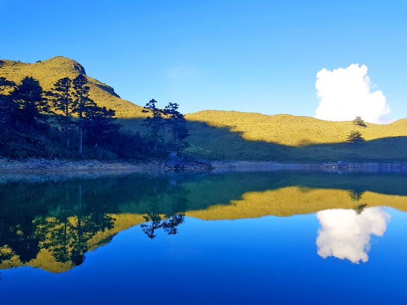
Photo: Tyler Cottenie
As I walked up this 50-odd-kilometer-long road, traces of Taipower activity were everywhere. Buildings used to house workers from different decades are spaced regularly along the way, with the largest complex, around 24km in, being the location most commonly chosen by hikers to spend the night.
There are buildings in various stages of ruin here, as well as one that is still actively used and maintained by Taipower: with an immaculate exterior and a manicured green lawn in front, it seems out of place in the otherwise derelict surroundings. Next to this building is a dilapidated former dormitory containing records of transmission line installation activity on the walls. Across the road is a massive helipad, with vehicles and machinery parked beside it that are still used for inspection and maintenance along the road.
The plan was to stop and eat here, but with the stench emanating from a rotting deer carcass next to the dormitory (the second dead sambar deer I had come across already) killing my appetite, I decided to carry on. Several former Bunun settlements can also be accessed from this road; these trails are now marked with colorful signs displaying the settlement’s name in Latin script. I later passed large, multi-tiered cabbage fields that had to be abandoned after the bridges connecting this road to the outside world were wiped out. They are now nothing but weed-choked, trash-ridden scars on the landscape.
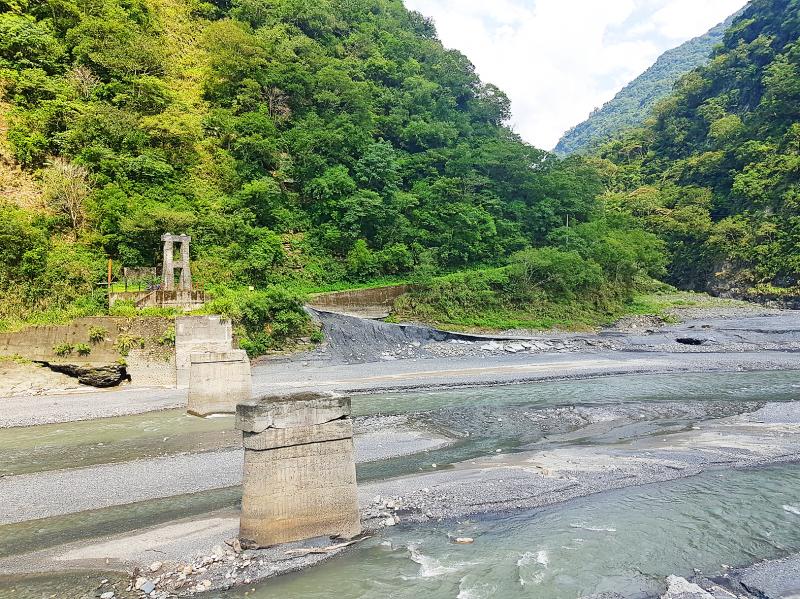
Photo: Tyler Cottenie
In the higher reaches of the road, there is another worker’s dormitory with platform and bunk beds that can still hold dozens of people comfortably under its intact roof. This is the Sunhai Boarding House (孫海招待所), named after the owner of one of Taiwan’s biggest logging companies during the mid-20th century; his company also built the road itself. Across the road from the dormitory is the Haitian Temple (海天寺). Despite its faded decorations, overgrown surroundings and remote location, it is still remarkably intact, and has the honor of being Taiwan’s highest temple.
After over 50km of walking over two days, I finally reached the end of the road, where the transmission towers cross over the spine of the Central Mountain Range at nearly 3,000 meters in elevation. The towers continue down the east side, meeting up with the Wanrong Forest Road (萬榮林道) and continuing down to Fenglin in Hualien. Tucked in a valley just below Taiwan’s highest transmission tower is Taiwan’s second-deepest alpine lake, Cicai Lake.
A HIKING DESTINATION
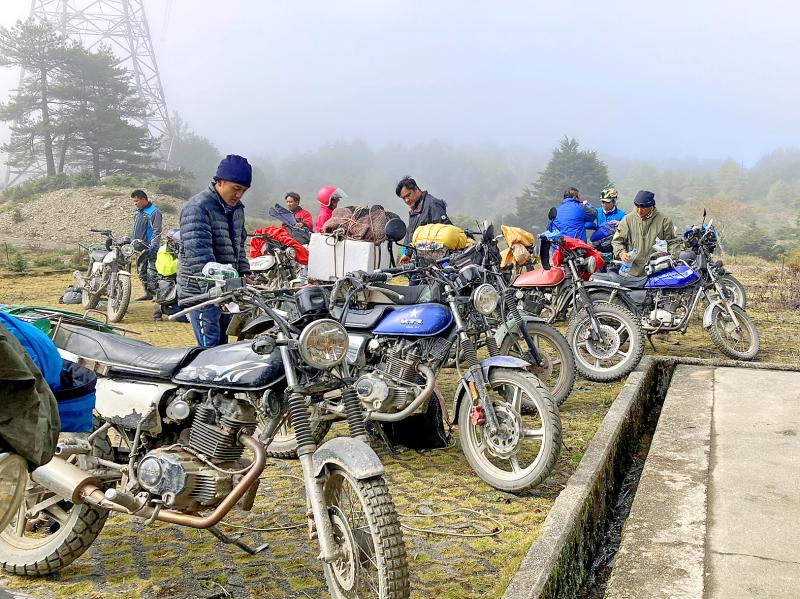
Photo courtesy of Robert Minor
Decades ago, access to the lake was easy and it was one of the most popular destinations in Taiwan’s high mountains. Large numbers of hikers and excessive jeep traffic damaging the environment eventually prompted the installation of a gate several kilometers from the lake to discourage hikers. Bridges being wiped out compounded the problem of hiking access, and as the trend of closing off mountain areas grew, Cicai Lake and nearby Liuoshun Mountain (六順山) were soon officially off limits to hikers. For years, the only way up involved sneaking around a checkpoint, or sneaking in with a local who had special permission. All this changed, however, with the opening up of forest roads to the public late last year.
The lake, which sits near the border of Nantou and Hualien Counties, is now legally accessible both from the east and the west. From the east, it is possible to walk the length of the Wanrong Forest Road, hike up a steep trail to an old Taipower worker’s hut, and finally take a trail over Liushun Mountain to the lake, or a treacherous trail following an old logging railroad directly to the lake. From the west, it is possible to walk along the Danda Forest Road all the way to the transmission towers adjacent to the lake. Whether you choose to go in and out from the same trailhead or complete a full east-west traverse, you are looking at a hike of a hundred kilometers or more spread over several days.
For those short on time, lacking in fitness or willing to pay for the convenience, there is another option: Local Aborigines in Nantou have access to the Danda Forest Road and will take you up and back by motorcycle, while also handling food and camping arrangements. Hanging on for dear life while riding over landslides on this semi-abandoned road is an experience you won’t soon forget.
Photo: Tyler Cottenie
Spending a night camping near the lake makes it clear how the lake got its name. The mirrorlike surface reflects the green of the surrounding hills, the blue daytime sky and the multihued sky at dusk and dawn. Sambar deer inevitably make their appearance nearby at night, as do countless stars, far from the light pollution of Taiwan’s cities. The remote location also ensures that the area will not be too crowded. I was the only visitor there on a Sunday night in July.
Just three hours on foot from the lake is Liushun Mountain. This peak was originally surveyed at over 3,000 meters and selected as one of the 100 Peaks of Taiwan. However, a later, more accurate survey put its elevation at just 2,999 meters, and it is now one of only two 100 Peaks under 3,000 meters.
As with many hikes in Taiwan, the Cicai Lake and Liushun Mountain route offers hikers both a glimpse into Taiwan’s past, and the chance to surround themselves with (relatively) unspoiled beauty.
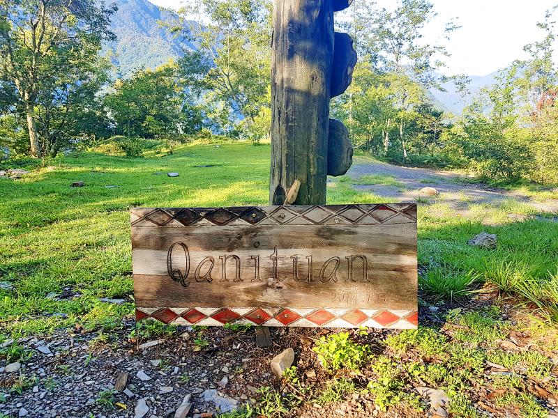
Photo: Tyler Cottenie
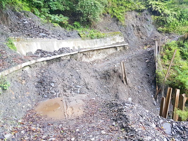
Photo: Tyler Cottenie
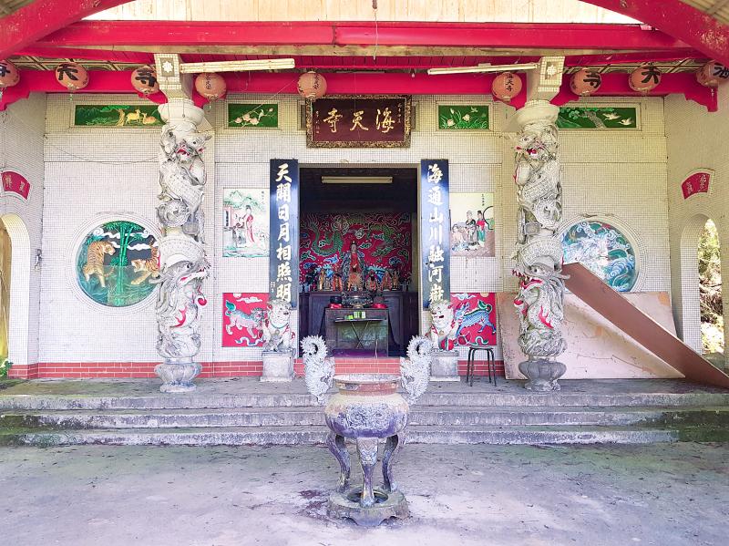
Photo: Tyler Cottenie

Photo: Tyler Cottenie

Last week the government announced that by year’s end Taiwan will have the highest density of anti-ship missiles in the world. Its inventory could exceed 1,400, or enough for the opening two hours of an invasion from the People’s Republic of China (PRC). Snark aside, it sounds impressive. But an important piece is missing. Lost in all the “dialogues” and “debates” and “discussions” whose sole purpose is simply to dawdle and delay is what the Chinese Nationalist Party (KMT) alternative special defense budget proposal means for the defense of Taiwan. It is a betrayal of both Taiwan and the US. IT’S
March 16 to March 22 Hidden for decades behind junk-filled metal shacks, trees and overgrowth, a small domed structure bearing a Buddhist swastika resurfaced last June in a Taichung alley. It was soon identified as a remnant of the 122-year-old Gokokuzan Taichuu-ji (Taichung Temple, 護國山台中寺), which was thought to have been demolished in the 1980s. In addition, a stone stele dedicated to monk Hoshu Ono, who served as abbot from 1914 to 1930, was discovered in the detritus. The temple was established in 1903 as the local center for the Soto school

Paul Thomas Anderson’s “One Battle After Another” was crowned best picture at the 98th Academy Awards, handing Hollywood’s top honor to a comic, multi-generational American saga of political resistance. The ceremony Sunday, which also saw Michael B. Jordan win best actor and “Sinners” cinematographer Autumn Durald Arkapaw make Oscar history as the first female director of photography to win the award, was a long-in-coming coronation for Anderson, a San Fernando Valley native who made his first short at age 18 and has been one of America’s most lionized filmmakers for decades. Before Sunday, Anderson had never won an Oscar. But “One Battle

In Kaohsiung’s Indigenous People’s Park (原住民主題公園), the dance group Push Hands is training. All its members are from Taiwan’s indigenous community, but their vibe is closer to that of a modern, urban hip-hop posse. MIXING CULTURES “The name Push Hands comes from the idea of pushing away tradition to expand our culture,” says Ljakuon (洪濬嚴), the 44-year-old founder and main teacher of the dance group. This is what makes Push Hands unique: while retaining their Aboriginal roots, and even reconnecting with them, they are adamant about doing something modern. Ljakuon started the group 20 years ago, initially with the sole intention of doing hip-hop dancing.