Summer has kicked off early this year, so hiking (at least at lower altitudes), is definitely not the most comfortable way to spend a weekend. The high mountains are still cool — and having just returned from climbing Jade Mountain (玉山), I can confirm it’s chilly up on top — but intense competition for permits often makes getting into the alpine center of the country a real headache.
MID-RANGE MOUNTAINS
That’s where Taiwan’s countless mid-range mountains (中級山; summits between about 1,500m and 3,000m) become an attractive proposal. Although some require a permit weeks in advance from the Forestry Bureau, the majority can be climbed with just a police permit (issued on the spot at a nearby police station); sometimes a permit isn’t even required. Best of all, hardly any of them are popular, so a peaceful day out in nature can be almost guaranteed.
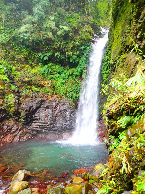
Photo: Richard Saunders
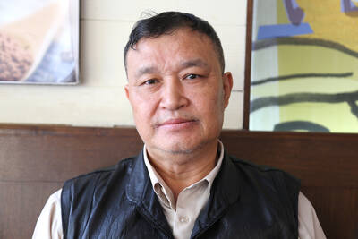
The fly in the ointment is that the vast majority of mid-range mountains are not widely climbed, and hiking conditions may be more strenuous than on many a higher but more popular mountain. However, one set of mid-range mountains that are accessible as day hikes to the average walker are Taichung’s Kukuan Seven Heroes (谷關七雄). This great septet of peaks is located in one of Taiwan’s three main Japanese-era logging regions, so there’s some historical interest as well, and looms over the magnificent Central Cross-island Highway (中部橫貫公路; Provincial Highway 8) in eastern Taichung. All seven trails are well signposted.
I already described two of the peaks, Baimao (白毛山, no. 6) and Dongmao (東卯山; no. 5) mountains, in this column on Nov. 10 last year, but the remaining five are also great climbs. A good and not-too-hard challenge when the weather cools off is to conquer all seven summits over four weekends.
The airy heights of the two highest peaks — Maluan (馬崙山, 2,305 meters) and Basian (八仙山, 2,366 meters) mountains — remain cool on the hottest of days, and the lowest of the seven, Tangmadan Mountain (唐麻丹山, 1,305 meters), features a beautiful waterfall, a perfect place to cool off after the hike.
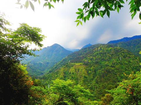
Photo: Richard Saunders
SCALING THE HEROES
The seventh and lowest of the seven Heroes, Tangmadan Mountain is the shortest hike of the seven (just over five kilometers return; allow 3 to 4 hours), and has the least vertical ascent. However, because the trail is so short it’s among the steepest and rockiest. The main trailhead is at Tongsin Bridge (同心橋), just south of Provincial Highway 8, eight kilometers west of Kukuan Village (谷關).
Right from the start it’s a steep, rocky climb as the trail threads a narrow ridge with precipitous drops on either side. Keep straight ahead at the junction and the trail continues steeply upwards to the summit, which offers partial but impressive views.
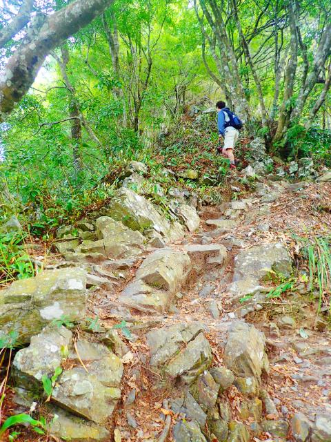
Photo: Richard Saunders
Follow the trail ahead down the other side and it descends to another junction. Here, before heading back down to the trailhead by following the trail on the left, you’ll probably want to fork right, dropping down to a stream, and the small but lovely Butterfly Valley Waterfall (蝴蝶谷瀑布), with a deep, cold pool at its base.
In Hoklo (more commonly known as Taiwanese), Pojinjia Mountain (波津加山; 1,772 meters, the fourth Hero) apparently means “really steep mountain,” and it’s a sustained slog to the summit (about 6 hours return) along a trail that starts beside the Siji Hot Spring Resort (四季溫泉會館). This is perhaps the most scenic of the seven Heroes, and there are awesome views from the summit, crowned with a distinctive overhanging rock formation.
Along with Dongmao and Pojinjia mountains, Wuwowei Mountain (屋我尾山; 1,796 meters, no. 3) is the finest of the seven peaks. There are two trailheads. Unfortunately, although still useable, the steep, rocky and quite challenging trail from the south (the more interesting route by far), is officially closed. A much quicker and gentler route leads to the summit from the Dasyueshan Forest Road (大雪山林道) in the north and, unusually, goes down to reach the summit.
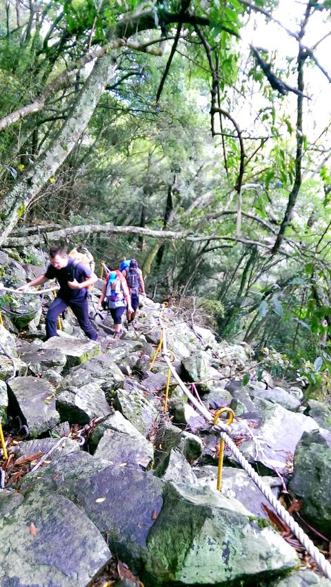
Photo: Richard Saunders
The second highest Hero, Maluan Mountain is a very fine hike, with a couple of good views, and the scant ruins of a Japanese-era logging village and railway at the half-way point. Reached by the longest trail of the seven (13km return; 6 to 7 hours), it’s a fairly straightforward climb, with just two very steep stretches, one near the start and another right at the end, which is cruelly trying at the last stages of a long uphill hike. The trailhead lies several kilometers up Taidiansiang (台電巷), which leaves Provincial Highway 8 two kilometers east of Kukuan Village, and is too narrow for anything larger than a small minibus to get through.
Finally then, the tallest and most popular Hero, Basian Mountain. Personally I think it’s the least interesting hike of the seven. The trailhead is inside Basian Forest Recreation Area (八仙森林遊樂區). During the six kilometer-long climb there’s some lovely woodland (especially a small but magical area of forest dripping with mosses and lichens just before the top), but the summit itself is a huge, undefined plateau. There is a large, flat area of scrappy grass beside the summit plaque, an untidy thicket and no view whatsoever.
Unless enjoying those cool summer breezes at nearly 2,400 meters are the main reason for lugging yourself and several liters of water to the summit, it’s probably better to stick with one of the more scenic Heros, at least the in summer.
Richard Saunders is a classical pianist and writer who has lived in Taiwan since 1993. He’s the founder of a local hiking group, Taipei Hikers, and is the author of six books about Taiwan, including Taiwan 101 and Taipei Escapes. Visit his Web site at www.taiwanoffthebeatentrack.com
Taiwan has next to no political engagement in Myanmar, either with the ruling military junta nor the dozens of armed groups who’ve in the last five years taken over around two-thirds of the nation’s territory in a sprawling, patchwork civil war. But early last month, the leader of one relatively minor Burmese revolutionary faction, General Nerdah Bomya, who is also an alleged war criminal, made a low key visit to Taipei, where he met with a member of President William Lai’s (賴清德) staff, a retired Taiwanese military official and several academics. “I feel like Taiwan is a good example of
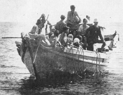
March 2 to March 8 Gunfire rang out along the shore of the frontline island of Lieyu (烈嶼) on a foggy afternoon on March 7, 1987. By the time it was over, about 20 unarmed Vietnamese refugees — men, women, elderly and children — were dead. They were hastily buried, followed by decades of silence. Months later, opposition politicians and journalists tried to uncover what had happened, but conflicting accounts only deepened the confusion. One version suggested that government troops had mistakenly killed their own operatives attempting to return home from Vietnam. The military maintained that the

Before the last section of the round-the-island railway was electrified, one old blue train still chugged back and forth between Pingtung County’s Fangliao (枋寮) and Taitung (台東) stations once a day. It was so slow, was so hot (it had no air conditioning) and covered such a short distance, that the low fare still failed to attract many riders. This relic of the past was finally retired when the South Link Line was fully electrified on Dec. 23, 2020. A wave of nostalgia surrounded the termination of the Ordinary Train service, as these train carriages had been in use for decades

Lori Sepich smoked for years and sometimes skipped taking her blood pressure medicine. But she never thought she’d have a heart attack. The possibility “just wasn’t registering with me,” said the 64-year-old from Memphis, Tennessee, who suffered two of them 13 years apart. She’s far from alone. More than 60 million women in the US live with cardiovascular disease, which includes heart disease as well as stroke, heart failure and atrial fibrillation. And despite the myth that heart attacks mostly strike men, women are vulnerable too. Overall in the US, 1 in 5 women dies of cardiovascular disease each year, 37,000 of them