The oil market faced a rollercoaster week as traders tracked buoyant global equities, soaring US crude stockpiles and the global economic outlook, analysts said.
Crude prices almost hit one-month peaks on Monday, drawing strength from global economic recovery hopes, before diving under US$65 per barrel on Friday after poor growth data in top oil consumer the US.
“Financial markets continue to flip rapidly between bouts of optimism and pessimism,” Barclays Capital analyst Kevin Norrish said.

“So far this summer, a fairly consistent pattern has been established whereby markets rally strongly for a few weeks on better-than-expected economic data, before suffering a collective loss of confidence when that run is interrupted by something less positive,” he said.
OIL: Crude prices shot higher on Friday, propelled by news the US economy shrank less than expected in the second quarter, offering more hope for an economic rebound.
A sharp decline in the dollar also helped support the oil rally.
New York’s main contract, light sweet crude for September, jumped US$2.51 to close at US$69.45 dollars a barrel on Friday, from US$67.00 one week earlier. In London, Brent North Sea crude for September delivery gained US$1.59 to settle at US$71.70 a barrel, against US$69.31 a week earlier.
The New York session was volatile, with the barrel swinging in a range of nearly US$5.
PRECIOUS METALS: Prices mostly fell on falling investment demand.
“Investment buying continues to wane,” Barclays Capital analysts said. “Prices are likely to continue to track the day-to-day movements of the dollar, unless we see medium-term investment buying returning to levels seen earlier this year.”
By late Friday on the London Bullion Market, gold fell to US$939 an ounce from US$951.50 a week earlier.
Silver sank to US$13.63 an ounce from US$13.78.
On the London Platinum and Palladium Market, platinum firmed to US$1,189 an ounce at the late fixing on Friday from US$1,186.
Palladium decreased to US$256 an ounce from US$258.
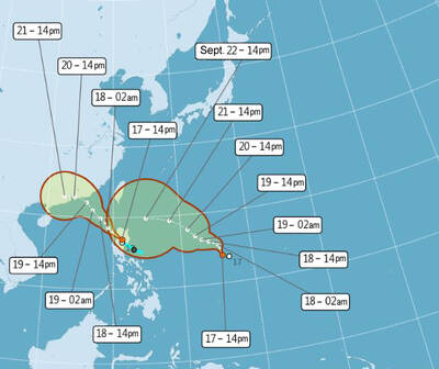
One of two tropical depressions that formed off Taiwan yesterday morning could turn into a moderate typhoon by the weekend, the Central Weather Administration (CWA) said yesterday. Tropical Depression No. 21 formed at 8am about 1,850km off the southeast coast, CWA forecaster Lee Meng-hsuan (李孟軒) said. The weather system is expected to move northwest as it builds momentum, possibly intensifying this weekend into a typhoon, which would be called Mitag, Lee said. The radius of the storm is expected to reach almost 200km, she said. It is forecast to approach the southeast of Taiwan on Monday next week and pass through the Bashi Channel
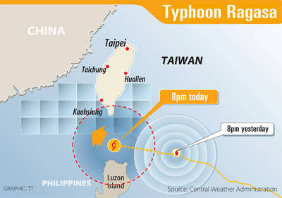
WARNING: People in coastal areas need to beware of heavy swells and strong winds, and those in mountainous areas should brace for heavy rain, the CWA said The Central Weather Administration (CWA) yesterday issued sea and land warnings for Typhoon Ragasa, forecasting that it would continue to intensify and affect the nation the most today and tomorrow. People in Hualien and Taitung counties, and mountainous areas in Yilan and Pingtung counties, should brace for damage caused by extremely heavy rain brought by the typhoon’s outer rim, as it was upgraded to a super typhoon yesterday morning, the CWA said. As of 5:30pm yesterday, the storm’s center was about 630km southeast of Oluanpi (鵝鑾鼻), Taiwan’s southernmost tip, moving northwest at 21kph, and its maximum wind speed had reached

The Central Weather Administration (CWA) yesterday said that it expected to issue a sea warning for Typhoon Ragasa this morning and a land warning at night as it approached Taiwan. Ragasa intensified from a tropical storm into a typhoon at 8am yesterday, the CWA said, adding that at 2pm, it was about 1,110km east-southeast of Oluanpi (鵝鑾鼻), Taiwan’s southernmost tip. The typhoon was moving northwest at 13kph, with sustained winds of up to 119kph and gusts reaching 155kph, the CWA Web site showed. Forecaster Liu Pei-teng (劉沛滕) said that Ragasa was projected to strengthen as it neared the Bashi Channel, with its 200km

PUBLIC ANNOUNCEMENTS: Hualien and Taitung counties declared today a typhoon day, while schools and offices in parts of Kaohsiung and Pingtung counties are also to close Typhoon Ragasa was forecast to hit its peak strength and come closest to Taiwan from yesterday afternoon through today, the Central Weather Administration (CWA) said. Taiwan proper could be out of the typhoon’s radius by midday and the sea warning might be lifted tonight, it added. CWA senior weather specialist Wu Wan-hua (伍婉華) said that Ragasa’s radius had reached the Hengchun Peninsula by 11am yesterday and was expected to hit Taitung County and Kaohsiung by yesterday evening. Ragasa was forecast to move to Taiwan’s southern offshore areas last night and to its southwestern offshore areas early today, she added. As of 8pm last night,